A-Walking: Weardale Wanderings
Our three expeditions this Sunday (28th February) took us into the heart of Weardale in County Durham. The A-group started at Frosterley; the B-walk commenced at Wolsingham and the C-party departed from Eels Bridge. All three walks finished in Bishop Auckland.
The overall intent of the A-walk was to pick up the route of the Weardale Way (WW) (near Harehope Quarry) and then follow it towards, but not into, Wolsingham. Subsequently, we were to re-join the WW near Shipley Moss and then follow its route into Bishop Auckland. Details of the route of the Weardale Way can be found here.
We set off from Frosterley at about 11.50 am. There were six people in the group: JB, PB, RB, KF, LM and MS. PB led the walk.
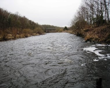
Leaving our drop-off point on the A689, at the east end of Frosterley {NZ 035 369}, we crossed the River Wear using the bridge at {NZ 036 369}. Unfortunately, there was too much water flowing to risk a ford crossing.

From the railway level crossing on the other side of the river, we turned left and followed the road around to Broadwood {NZ 037 366}. We continued along the road to {NZ 038 363} where we joined the route of the Weardale Way. Following this uphill to West Biggins, we skirted around Harvey Hill ready to make our final ascent up onto Pikeston Fell {NZ 042 344}. As we climbed, we had some good views of the 'Elephant Trees' on the horizon to our right.

Once we were on the fell, we continued in an easterly direction along the route of the WW. This took us along Sunnyside Edge to a path junction near Harthope {NZ 063 349}. At this point we changed to a north-north-easterly bearing and crossed a field to reach a gate at {NZ 064 352}. At this point we left the Weardale Way - which now went downhill towards Wolsingham. Instead, we maintained our height and made our way on a north-easterly bearing towards Rushy Lea Lane {NZ 066 355}. We followed the lane in a north-easterly direction to Snipe Cottage {NZ 068 355} and continued onwards to the minor road at {NZ 072 358}. Turning right, and then left, we followed the road in a (roughly) south-easterly direction to its junction with Howlea Lane {NZ 082 353}.
Keeping left, we continued along Howlea Lane towards Knitsley Fell. At {NZ 098 343} we took a track on our left that led us towards Shipley Moss {NZ 104 344}. Just after the farm, we re-joined the route of the Weardale Way at Bracken Hill Plantation {NZ 108 344}. We continued downhill to the farm at Bracken Hill {NZ 114 344}. It was now just a short trek to the aluminium bridge over the River Wear. As soon as we had crossed the river, we stopped for a very pleasant lunch stop on the east bank {NZ 117 345}.

After an enjoyable lunch stop sitting in the sun, we made our way to Low Harperley {NZ 119 349} and continued along the route of the Weardale Way. Subsequently, we stayed with this virtually all the way to our final destination.
From Low Harperley we maintained a south-easterly bearing to Harperley Hall {NZ 126 344} and Wadley Farm {NZ 132 339}. After passing through the farm, we turned south along Wadley Beck and then, after a gentle climb, made our way to NcNeil {NZ 134 326} and High Garth Farm {NZ 141 317}.
We continued south along the WW and at {NZ 141 313} turned east so as to cross the A68 road in order to enter the small village of Witton-le-Wear {NZ 145 312}. We navigated our way through the village and over the railway track. Making our way towards the old bridge at {NZ 148 307}, we decided to take a short tea break here - again sitting beside the River Wear.

By the time we had finished our tea stop, the weather conditions had started to deteriorate - initially rain and then snow. From our tea-stop location, we crossed the River Wear and then followed its south bank in an easterly direction towards Witton Park {NZ 172 302} and then Escombe {NZ 189 301}. We passed the Saxon church on our left and then made our way towards the south bank of the River Wear at {NZ 192 302}.
Leaving the village of Escombe, we followed the route of the river in an easterly direction towards Broken Bank where we encountered a problem with river erosion of our path. Once this had been overcome we progressed onwards to Bishop Auckland RUFC {NZ 202 298}. From here we had our final climb up into the centre of Bishop Auckland {NZ 209 301} where our coach was waiting to take us home.
During today's expedition we experienced all sorts of weather - sunshine, rain and snow. We also had to contend with path erosion near Broken Bank. Despite all this, we had a really great day. Use the buttons below to see where we went, how we did and some of the sights we saw.
Labels: A-Walking: Weardale Wanderings


0 Comments:
Post a Comment
Subscribe to Post Comments [Atom]
<< Home