C-Walking: Rosedale Rounders
The North-Yorkshire village of Rosedale Abbey is an excellent centre for walkers. From here it is possible to explore many different parts of the North Yorks Moors National Park. Today's expedition (5th July, 2009) took the form of a circular walk from the village - heading south to Lastingham (via High Askew) and returning via Ana Cross.
We set off from the village at about 10.54 am. There were 13 people in the group: Clive-G, Kath-H, Doreen-R, Joan-H, Jim-M, Pat-L, PB, Bryn-W, John-F, Margaret-B, Megan-H, Brian-H and Jan-S. PB led the walk.
From the village green we passed through the Parish Church of St Mary and St Laurence (see the picture below) and then headed in a westerly direction to reach a footbridge over the River Seven at {SE 721 959}. From here we had a gentle climb up through a meadow to meet the minor road at {SE 719 958} that runs in a south-westerly direction from Thorgill pass Sevenford House. Turning left, we followed this road to Red House Golf Course and onwards to a road junction at White Horse Farm Hotel/Inn {SE 724 955}.

At the road junction, we 'picked up' a public footpath that went in a south-westerly direction along a good farm track. Following this track down the valley, we passed by Newlands Farm and Hollins Farm {SE 733 944}. Our track continued in a SW direction - roughly following (on our left) the course of the River Seven. We had an early lunch stop in the shade of the trees at {SE 741 937} - just to the east of Cumratph Crag.
After lunch, we continued along our SW trek. As we approached Hartoft End (which was on the opposite side of the river), our path turned south and took us to High Askew {SE 744 913}. On this section of the walk we experienced heavy rain which necessitated the use of umbrellas and other water-proof equipment! Just after High Askew, we turned right and headed in a westerly direction towards the ford at Tranmire Beck {SE 740 907}. As we turned west off the track from High Askew, we encountered an impressive display of white and purple foxgloves.
After crossing the ford we entered a small wood at {SE 739 907} and then crossed a series of fields in order to get to the small village of Lastingham {SE 729 904}. We had a 20-minute stop here in order to explore the village and take in some of its history - particularly, that relating to Saint Cedd of Lastingham (see here for more details).
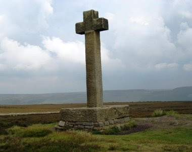
After our short stop in the village, we took an uphill road from the telephone box in a northerly direction. Passing the Lastingham Grange Hotel on our right, we passed through a wide gate onto Spaunton Moor. There were some wonderful displays of colourful heather to be seen here. We climbed gradually up onto Lastingham Ridge {SE 726 918} and continued our uphill climb to Ana Cross {SE 724 938} - almost the highest point of the walk. We took our short tea break here. Further details of this historic monument can be found by following this link.

From Ana Cross we had a gentle stroll across to the minor road at Bank Top (SE 722 948}. We crossed the road and continued on our northerly trek to reach the highest point on the walk at {SE 720 952} - there were some lovely views of Rosedale from here. We now turned right and commenced our rather steep descent towards Rosedale Abbey. As we lost height, we passed through Red House Golf course where we saw a beautiful display of Red-Hot Pokers and Petunia Surfinia (in a hanging basket).
We emerged from the golf course onto the minor road that we had previously walked along (Daleside Road) {SE 723 955}. From here, we took a straight, down-hill footpath to the road-bridge over the River Seven at {SE 724 957}. Turning left, we followed the road back to the coach, the village green and (for some) the Abbey Tea Room.

Overall, we had a great day. We were exposed to the extremes of weather conditions - both intense heat and torrential rain. Despite this, we experienced some really wonderful scenary. Use the buttons below to see where we went and some of the sights that we saw.
Addendum
During my pre-walk check for today's expedition I had considerable difficulty finding one of the public footpaths that I wanted to use. I reported my difficulties to the North Yorks Moors National Park Authority. I now eagerly await news of what will be done to re-instate this path. A copy of my report can be found at this link.
Labels: C-Walking: Rosedale Rounders


0 Comments:
Post a Comment
Subscribe to Post Comments [Atom]
<< Home