A-Walking: Middleham Mania
During the last few months, Middleham {SE 127 878} has figured prominently in a number of our walking expeditions.
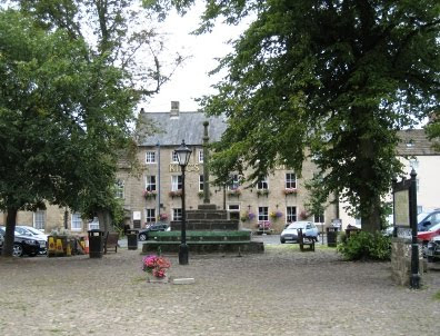
In relation to today's expedition, this delightful village was the destination of our trek from Masham {SE 225 807} (see the picture below). Our route took us via Leighton, Gollinglith Foot, Colsterdale, Caldbergh Moor, Caldbergh and Braithwaite Hall.

We set off from Masham at about 11.00 am. There were nine people in the group: JB, PB, RB, CH, MH, JJ, PJ, LM and JP. PB led the walk.
We set off from our drop-off point on the A6108 road out of Masham {SE 222 809} in a westerly direction along Fearby Road. After about 140 yards, at {SE 221 809}, we turned onto a south-westerly bearing and headed for Westholme Road {SE 220 809} where we joined the route of the Ripon Rowel Walk. We followed this in a westerly direction across the fields to Micklebury Lane {SE 203 808} where we turned left. We went in a southerly direction down the lane for about 330 yards and then turned right at {SE 202 805} into Low Moor Lane. We continued our westerly trek in order to reach a minor road at {SE 187 804}. Turning left, we made a steep descent down the road (passing Swinton Saw Mill on our right) to reach a bridge at {SE 187 801}. We used this bridge to cross the River Burn.
From the bridge we followed the road and climbed in a southerly (becoming south-westerly) direction to Broadmires {SE 178 798}. We stopped here, very briefly, for a group photograph. We continued on our south-westerly trek until we reached {SE 168 793} where we now left the Ripon Rowel Walk. Turning onto a westerly bearing, we crossed Pott Beck (using an old stone bridge at {SE 166 793}) and then climbed up to the minor road at Leighton {SE 163 796}. Turning right, we followed this in a north-easterly direction (downhill) to Leighton Bridge {SE 166 800}. Just before the bridge we turned left onto another minor road that took us in a westerly direction to Crab House {SE 163 802}.
Continuing along this minor road we climbed up to the ‘Leeds Pals’ war memorial {SE 156 801}. We had a short ‘interest stop’ here - in order to explore the memorabilia that was located there. We continued our climb along the minor road to a road junction at {SE 151 800} where we turned right and started our descent down towards the River Burn. We left the road at {SE 151 803} and followed a public footpath in order to reach the footbridge over the river at Gollinglith Foot {SE 153 810}. We stopped here for a short lunch break.
After lunch we set off in a westerly direction along a minor road that was to take us to Colsterdale. As we went along this road there were some good views of the River Burn on our left. During our climb up to Colsterdale we also had some good views of Slipstone Crags, Brown Beck Crags and Agra Moor on our right. When we reached Colsterdale, we turned right at {SE 130 813} and followed a farm track in a northerly direction. We used this track in order to get up onto the access land near High Crags {SE 128 815}. From here we found quite a good path that followed the 310- and 330-metre contour lines which led us to a path at {SE 113 820}. This took us to a ford at Slip Wath {SE 106 824} which we used in order to cross Barnley Beck. After making our crossing we had a good climb which followed a line of grouse butts on our left. Just after the highest point on the walk (1317 feet), at {SE 101 828}, we joined a good track (Red Way) at {SE 100 830} and followed this downhill towards Caldbergh. We stopped at {SE 095 849} for a short tea break. From this vantage point we had some good views of Penhill (to the north-west) and Leyburn (to the north-north-east).
After a ‘chilly’ tea stop, we continued our descent towards Caldbergh. Just before Caldbergh Hall {SE 094 850}, we turned right and followed a good track in a north-easterly direction to {SE 104 855}. At this point we left the track to follow a footpath across the fields to a minor road at {SE 113 859}. Turning right, we followed this in an easterly direction to Braithwaite Hall {SE 118 859}. We now took a northerly path down to Hullo Bridge {SE 118 865} where we crossed the River Cover. Turning right, we followed the course of the river to {SE 127 867}. Here we turned onto a northerly bearing and climbed up onto William’s Hill {SE 127 873}. As we descended from the top of the hill there were some good views of Middleham Castle and our final destination in Middleham {SE 127 877}.

Because we arrived at our destination a little earlier than expected, there was some time to partake of some light refreshments before boarding the coach to take us back home.
Use the buttons below to see where we went and how we did.
Labels: A-Walking: Middleham Mania


0 Comments:
Post a Comment
Subscribe to Post Comments [Atom]
<< Home