C-Walking: Swainby Strollers
Bearing in mind the coach cancellations in early January, today's programme of walks was the first in 2010 to involve our usual three walk options. Our venue was the north-western region of the North York Moors (as defined in OS Sheet 26). The A-walk set off from Stokesley, the B-walk commenced at Ingleby Arncliffe and the C-walk departed from Swainby. The destination of all three walks was Ingleby Greenhow.
As mentioned above, today's C-route took us from Swainby {NZ 476 022} to Ingleby Greenhow via Faceby, Carlton in Cleveland, Kirkby and Great Broughton.
We set off from the public conveniences in Swainby at about 10.10 am. There were nine people in the group: DB, LB, PB, PI, CL, SQ, DR, DT and MT. PB led the walk.

After crossing Scugdale Beck using the footbridge, we walked along the left-bank of the beck towards Holy Cross Church {NZ 477 020} where we turned left along Whorlton Lane. We followed the lane in a north-easterly direction, passing Whorlton Castle (on our left) and the church (on our right) to reach a footpath at {NZ 484 025}. Using this path, we climbed uphill around the western side of Whorl Hill towards the village of Faceby {NZ 496 031}. Just before entering the village we had a short coffee stop on the conveniently located outdoor seats at the north-eastern end of the village church {NZ 496 030}.
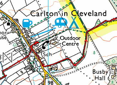
We walked through Faceby along the minor road that goes to the A172. At {NZ 495 033} we turned right, off the road, and headed in a north-easterly direction across the fields to Carlton in Cleveland. From here we had planned to take the public footpath at {NZ 509 043} opposite the blacksmith's shop. Unfortunately, we found that this path was not passable due to extensive flooding. This meant that we had to implement an unexpected diversion - see the map section below (the red line denotes the GPS tracklog).

We re-joined our originally planned route at {NZ 513 045}. From here, we made our way across the fields to the village of Kirkby - where we had our lunch stop. Our route was not scheduled to go through the village itself; however, because the ground was so wet we diverted into the village in search of somewhere dry to sit.

The seating arangements for lunch necessitated that we split up into three small sub-groups - each one allocated to a particular bench within the village (one on the village green, one outside the church and one at the bus stop).
After lunch, we re-traced our steps back to our originally planned route at {NZ 539 058}. We now continued our north-easterly trek across the fields to reach a minor road at {NZ 545 063}. Turning right, we followed this road into Great Broughton {NZ 547 063}. Now walking in an east-north-easterly direction, we passed the village hall (on our left) and then took a public footpath on our right at {NZ 549 063}. Initially, this took us on a south-easterly bearing but then changed to an easterly direction in order to take us across the fields to Meynell Hall {NZ 564 062}.
Interestingly, as we passed through this section of the walk, and the next one towards Bonny Hill {NZ 569 054}, we encountered lots of fields containing a 'reed-like' crop which looked something like bamboo canes. We were informed by a local farmer that this was called 'elephant grass' - its technical name being 'Miscanthus'. Apparently, this is being grown as an experimental bio-fuel.
As we approached Bonny Hill, I noticed that the way-marked route of the footpath (which we followed) was different from the route as marked on both the digital and paper versions of the OS 26 maps (see the section of the digital tracklog below). I guess it's just as well we check out our walks before we do them!

From Bonny Hill, we headed south to Beck House where we joined the minor road at {NZ 571 050}. From Beck House, I had planned to take the north-easterly path up to Bonnie Hill Farm. Unfortunately, I missed the turning onto the footpath and so I had to 'push on' as best I could using my map rather than my GPS!
Turning left onto the road (from Water Beck Farm) we trekked in a north-easterly direction to the road junction at Folly Farm {NZ 581 054}. Turning left into Lamb's Lane, we followed the road for about 200 yards and then turned right along the footpath towards Ingleby Manor. At {NZ 584 055} we turned left onto a northerly bearing and made our way across the fields to reach some smooth, 'slimey and slippery', stone steps. We descended these with care and then used the footbridge (rather than the ford) to cross Ingleby Beck and arrive at the church {NZ 581 062} - see the picture below.

The path now led us through the church grounds and up to the centre of Ingleby Greenhow {NZ 581 064} where our coach was waiting for us in the centre of the village.
Well, we had a really great day - full of interest and excitement. The weather was kind to us and, even though it was wet and muddy underfoot, we did not get any substantial volumes of rain.
Labels: C-Walking: Swainby Strollers


0 Comments:
Post a Comment
Subscribe to Post Comments [Atom]
<< Home