A-Walking: Reeth Roundabout
The location of our three walks this Sunday (18th April) was 'spread out' over two beautiful North Yorkshire dales: Wensleydale (where our walks began) and Swaledale (where our adventures finished). Both the A-Walk and the B-Walk set off from the village of Wensley (see the picture below) while the C-Walk commenced at Leyburn. All walks finished in the lovely town of Reeth {SE 038 993}.

After leaving Wensley {SE 092 897}, the intent of the A-Group's expedition was to visit Castle Bolton, Dent's Houses, Apedale Head, Isles Bridge and Surrender Bridge before arriving at our final destination in Reeth.
We set off from our drop-off point on the A689 road in Wensley {SE 091 896} at about 11.08 am. There were eight people in the group: PB, RB, KF, JG, CH JJ, LM and JP. JJ led the walk.
Leaving the village in a westerly direction, we entered Wensley Park and followed the access road to Middle Lodge {SE 083 896}. Continuing along the road we passed the very impressive Bolton Hall on our right {SE 075 897}. Beyond the Hall, the road 'deteriorated' to a track which took us into West Wood {SE 071 896}. As we passed through the wood, we had some good views of the River Ure on our left.
We left the wood at {SE 059 901} and followed the public footpath across the fields in a north-westerly direction to reach the village of Redmire {SE 046 912}. After passing through the village, we crossed Apedale Beck at {SE 043 914} and then continued on our north-westerly trek to reach Castle Bolton {SE 036 919}. As we approached the village we had some magnificant views of the castle.

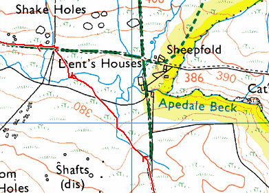
From the village we took a path at {SE 035 919} that led us into the first major climb of the day. Heading in a north-north-westerly direction we had a long and arduous climb upon onto the top of Black Hill {SE 031 934}. Once we were on the high ground, we had a pleasant trek along a track that would have taken us to Dent's Houses {SE 030 942}. However, the walk leader decided that she would 'cut a corner' and, in so doing, took us across some boggy, rough terrain (see the red line in the map section below).

Crown Copyright (2009). All rights reserved. Licence No. 100046831.
Produced using Memory-Map.
Produced using Memory-Map.
After crossing Apedale Beck, we joined the westerly track (Apedale Road) from Dent's Houses at {SE 027 943}. We then followed this in a westerly direction across East Bolton Moor and along the northern side of Smithy Gill. We stopped for lunch at {SE 005 952} near Apedale Head {SE 003 953}. This gave us some very impressive views of the land to the east of us.
From our lunch location we continued on a bearing of 288° to reach the old lead mine on Whitaside Moor {SD 989 956}.
Maintaining our north-westerly bearing, we descended from the high ground - now passing through a substantial area of disused mine workings as we went. We crossed High Lane at {SD 982 964} and continued our descent down to Haverdale Beck Bridge {SD 976 973} where we turned right along a minor road. After 75 yards we turned left and followed the road to Isles Bridge. As we crossed the bridge we had some good views of the River Swale {SD 977 975}.

From the bridge we made our way to the B6270 road at {SD 977 976}. We now had our second major climb of the walk. We zig-zagged uphill in a northerly direction to reach Turnip House {SD 978 981} and, beyond this, the small community of houses at Blades {SD 980 985}.
Leaving Blades in a north-easterly (NE) direction, we continued to climb up to and across Feetham Pasture {SD 986 991}. Continuing on our NE trek, we reached a minor road at {SD 990 995}. Turning left along the road we descended down to Surrender Bridge {SD 988 999}. After using the bridge to cross Barney Beck, we stopped on the northern bank for a short tea stop.

After our very pleasant tea break we continued in an easterly direction towards the ruined remains of the old smelting mill {SD 991 999}. We then swung onto a north-easterly bearing and made our way towards Cringley Bottom {NY 998 002}. At {NZ 002 001} we turned onto a south-easterly bearing and trekked towards Thirns {SE 011 995}. Here we joined a minor road that took us on a steep descent to the small village of Healaugh {SE 018 990}. Turning left onto the B6270 road, we followed this for about 180 yards and then turned right onto a public footpath at {SE 019 991}. This took us in a south-south-easterly direction to the northern bank of the River Swale {SE 021 988}.
Turning left along the bank of the river, we now followed a riverside footpath to {SE 028 991} near Hutton Garth. At this point we left the river and followed a field path in an easterly direction to arrive at our final destination in Reeth {SE 039 992} where we met up with our coach.
Many thanks to JJ and JG for organising such an interesting and exciting adventure for us today. We had a really great time. Use the buttons below to see where we went, how we did and some of the photographs that were taken.
Labels: A-Walking: Reeth Roundabout


0 Comments:
Post a Comment
Subscribe to Post Comments [Atom]
<< Home