A-Walking: Coniston Climber
Our three expeditions on Day-1 of our Lakes trip (Saturday, 8th May) each took place in the Furness Fells area of the south-central region of the Lake District (OS Explorer Sheets 6 and 7). The A-Walk set off from High Cross (near Oxen Fell) on the A593 road {NY 328 017}, the B-Walk started nearby at {NY 329 022} and the C-Walk commenced at Skelwith Bridge. All three walks finished in Coniston {SD 304 976}.
After leaving High Cross {NY 328 017}, the intent of the A-Walk was to visit High Tilberthwaite, Wetherlam, Swirl How, Levers Hawse and The Old Man of Coniston before arriving at our final destination in Coniston {SD 304 976}.
We left our drop-off point at about 09.40 am. There were eight people in the group: JB, PB, RB, MC, JH, KF, LW and FEW. RB led the walk.
After an initial ascent in a north-north-westerly direction along a good track, we swung onto a westerly bearing and dropped down into High Oxen Fell {NY 323 018}.

Continuing on our westerly trek we made our way to {NY 319 019} where we turned left onto a south-westerly bearing. We maintained this bearing following a path along the north-western edge of Furness Fells until we reached Holme Ground {NY 311 011}. From here we navigated a route in a north-westerly direction to join a minor road at High Tilberthwaite {NY 308 013}. Turning left, we followed this to Low Tilberthwaite {NY 305 011} where we took a public footpath on our right. We followed this to Tilberthwaite Gill (on our left) {NY 300 007} and then continued climbing in a north-north-westerly direction to near Birk Fell {NY 295 017} where we turned onto a south-westerly (SW) bearing.
From here, we climbed up along Wetherlam Edge to reach our first summit of the day on Wetherlam (762 m) {NY 288 011}. Maintaining our SW bearing, we made our way across Prison Band to reach Swirl How {NY 272 005}. From our lunch location we had a good view south towards our next destination (The Old Man of Coniston) - see the picture below.

After our lunch stop we made a southerly trek to Great How Crags {SD 273 999} and, after stopping to admire the view, continued on to Levers Hawse {SD 270 994}. As we went south, we had some good view of Levers Water (on our left) and Seathwaite Tarn (on our right). Continuing in a southerly direction we eventually reached the final summit on our expedition: The Old Man of Coniston (803 m) {SD 272 978}.
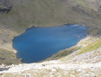
From the summit, our steep descent path took us in a north-easterly direction towards Low Water - see the picture below. When we reached the tarn we decided that we would stop for a short tea break near its eastern extremity {SD 275 982}.

As we left the lake and descended in an easterly direction to Crowberry Haws we saw extensive evidence of the mining and quarrying that had taken place in this area in bygone days. There were also some impressive waterfalls to be seen as we looked north towards the Coniston Fells.
We continued our descent in an easterly direction until we reached Church Beck {SD 293 981} when we turned onto a south-easterly bearing. We maintained this bearing until we arrived at the outskirts of Coniston {SD 300 975}. From here we had just a short easterly stretch to the A593 road and the car park {SD 303 975} in which our coach was waiting to take us back to Ambleside Youth Hostel
Many thanks to RB for organising such an interesting and exciting adventure for us today. We had a really great time - the climbs were hard but the views were terrific. Use the buttons below to see where we went, how we did and some of the photos.
Labels: A-Walking: Coniston Climber


0 Comments:
Post a Comment
Subscribe to Post Comments [Atom]
<< Home