A-Walking: Hebden Hike
Our three expeditions this week (Sunday, 2nd May) each took place in the Wharfedale area of North Yorkshire. Both the A-Walk and the B-Walk started at Hebden and the C-Walk commenced at Grassington. All three walks finished in Kettlewell.
After leaving Hebden {SE 026 632}, the intent of the A-Walk was to visit Grassington, Yarnbury, Kelber, Mossdale, Sandy Gate, Blake Hill, Great Whernside and Providence Pot before arriving at our final destination in Kettlewell {SD 968 723}.
We left our drop-off point at about 10.50 am. There were seven people in the group: JPB, PB, RB, KF, CH, JH and LM. PB led the walk.

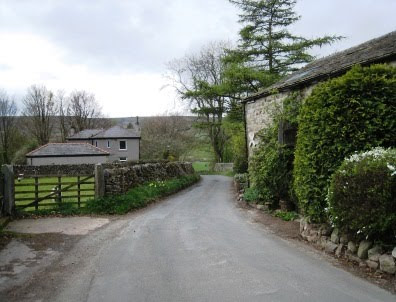
From our drop-off point on the B6265 road in Hebden, we set off in a south-easterly direction along Mill Lane (see picture above) towards the stepping stones and suspension bridge near Mill Bridge {SE 026 624}. At this point we turned right along a public footpath that took us to the River Wharfe {SE 024 624} where we joined the Dales Way long-distance footpath. We followed this in a westerly direction along the side of the river to meet the B6265 road in Grassington {SD 998 639}.
Turning onto a north-easterly bearing we passed through the north-west part of the town to join a minor road at {SE 003 642}. We followed this uphill (passing a covered reservoir on our right) to reach Spring House {SE 009 647}. Continuing along Moor Lane in a north-north-easterly direction, we passed Mire House {SE 011 650} on our right and continued on to Yarnbury {SE 015 659}.
Just after passing Yarnbury Grange, we turned left onto a north-westerly bearing and followed a good, walled-track. As we went along this, there was extensive evidence on our left of the extensive mining that once took place in this area. At {SE 008 669}, we passed High Barn on our left and continued in a northerly direction over Downs Pasture. A little further north, near Seeds Hill {SE 007 680} we decided to take advantage of what cover there was and stop for a short lunch break.
After lunch, we continued on our northerly trek to reach Kelber where we met a track junction at {SE 005 686}, Turning right onto a north-easterly direction we passed over the dried-up ford at Bycliffe {SE 010 692} and continued onwards to Mossdale. There were some impressive views of Mossdale Scar {SE 016 698} as we passed through the dale. We crossed Mossdale Beck near the ford at {SE 020 701} - see the picture below.

From the ford we had a good climb up to the stone shelter at {SE 026 708} where we paused for a quick 'drink stop'. Continuing on from the shelter, we made our way up to the boundary fence at Sandy Gate {SE 030 712} where we turned left onto a northerly bearing. Keeping the fence on our left, we trekked over rough moorland terrain until we reached {SE 031 720}; we now changed onto a bearing of 321°. Maintaining this bearing, we passed over Blake Hill {SE 025 729} and continued, still with the boundary fence on our left, to {SE 019 736}.
At this point we turned left and headed in a westerly direction. Our route now involved making our last climb of the day - up onto the high ground at Stone Head Crag {SE 009 734}. There were now some strong cold winds blowing. However, the rocks that we found there provided some good cover for our tea stop. From our vantage point, we had some tremendous views to the east: Angram Reservoir and Scar House Reservoir were clearly visible far below us.
On departing from our tea stop location, we made our way west towards the two cairns on the southern edge of Great Whernside. Now taking a bearing of 328° we navigated our route to reach the trig point at {SE 002 739} - OSBM 2976. There were some magnificant views to the west from here - including one of our forthcoming destination in Kettlewell.
Leaving the trig point on Great Whernside, we descended from the high ground in a west-south-westerly direction towards Hag Dike {SD 990 733}. From here we continued our descent (now in a south-south-easterly direction) until we reached Providence Pot {SD 992 729}. We found an interesting vertical mine-shaft here - probably used by pot-holers. To see a picture of the entrance, click here; to look down inside, click here.
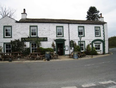
We were now at the bottom of a steep-sided V-shaped valley through which ran Dowber Gill Beck. We followed the course of the stream in a westerly direction towards Kettlewell {SD 968 723} and the Racehorses Hotel (see picture below) - near to which our coach was waiting on the B6160 road ready to take us home.

We had another interesting and exciting expedition today which took us through some spectacular North Yorkshire scenery. Use the buttons below to see where we went, how we did and some of the photos.
Labels: A-Walking: Hebden Hike


0 Comments:
Post a Comment
Subscribe to Post Comments [Atom]
<< Home