A-Walking: The Rothbury Roundabout
It has been quite a while since we last walked in the Coquetdale area of Northumberland. This trip to Rothbury was therefore a very welcome event - and the weather was superb.
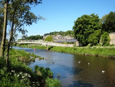
Our route today (2009-05-31) took us on a circular trek from Rothbury {NU 057 015} to The Beacon, Simonside, Chartners, Bickerton and Summerville. We set off at about 11.00 am from the car park on the bank of the River Coquet (see the picture below). There were 10 of us in the group: JB, LB, PB, RB, CH, PJ, WM, GT, JY and PY. WM led to walk.
From the riverside car park we turned into a narrow lane at {NU 059 015} and began our climb up to the small village of Whitton. Leaving the village on a southerly bearing, we passed Sharpe's Folly on our right and crossed Whitton Dean at {NU 058 002}. Following our climb up towards Garleigh Moor, we entered 'Cup & Ring' terrain. Although we looked on quite a few rocks, we could not see any of these interesting markings.
Click here and/or here to find out more about these fascinating rock markings and bronze-age Northumberland - including a photographof a 'real' stone circle!
We continued our southerly trek until we reached {NZ 058 992} where we took a south-westerly bearing in order to reach the car park on the minor road {NZ 052 988} just to the west of Lordenshaw. From here we had our first major climb of the day - up onto The Beacon {NZ 046 986}. Now keeping our westerly bearing, we continued to climb up to Dove Crag {NZ 037 985}. As we walked west, we had some tremendous views of the surrounding Northumbrian countryside. Our next climb took us up onto Old Stell Crag {NZ 030 984}. We stopped for lunch on the western side of the crag {NZ 271 985}.
After our lunch break, we continued onwards to the highest point of the walk (about 1400 ft) - the cairn on Simonside itself {NZ 024 987}. From here we had a short, very steep descent down to the edge of the forest at {NZ 021 988} where we picked up a very well-defined forest track. We followed this in a south-westerly direction to reach Chartners {NZ 002 957} and the 'Border Country Ride'. Here we turned onto a northerly (becoming north-westerly) bearing which took us pass a number of 'stunning', colourful rhododendron bushes.

We emerged from the forest at {NY 994 970} and, keeping our NW bearing, headed for Whitefield Hill {NY 986 974}. Just beyond this, at {NY 980 981} we turned through 90° onto a NE bearing and started our descent to the low ground near the River Coquet. As we approached Hepple Whitefield, we noticed what we thought were 'stone circles' in a field to the east of Whitefield Burn. WM later revealed what they really were!
After passing through Hepple Whitefield Farm we joined the minor road at {NY 987 996} and followed this in a north-easterly direction to Bickerton {NT 996 002}. Here we picked up a public footpath that took us across to the lake at Caistron {NT 997 006} where we were happy to take a short tea stop - watching the geese and swans.
Following our short stop, we continued on our NE trek along the side of the lake and then swung east to re-join the minor road near Ryehill. We continued along the road to a point just beyond Summerville {NU 034 010} where we turned left onto a permissive track. This took us to a footbridge at {NU 043 012} where we made our first crossing of the River Coquet. Heading towards the B6341 road, we followed a good footpathalong the northern bank of the river that took us back to Rothbury. Using the footbridge at {NU 057 015} (see the picture below) we crossed the River Coquet for a second time in order to get back to our coach which was waiting for us in the car park.

As we were back about 15 minutes early, some of us took advantage of the river in order to cool our aching feet.
Durng the course of today's walk I took a total of 63 photographs! Bearing in mind that we were walking for about 6 hours, that works out at about 10 per hour or, one every six minutes! This interesting statistic reflects what wonderful scenary and happenings we encountered.
Use the buttons below to see where we went, how we did and a selection of the photographsthat were taken.
Many thanks to WM for taking us on such a splendid walk and sharing with us his research into the 'stone circles' that we saw as we approached Hepple Whitefield.
posted by philbee @ 11:15
2 Comments
![]()


2 Comments:
63 photos, Phil. Not bad going, I had only taken 155 on my coast to coast in 12 days. Looks like you all had a fun day out, I was at Reeth doing a week-end of cycling. See you Sunday, for Clay Bank area.
Hello Martin. Well, your 155 averages out to about 13 per day - which isn't really bad at all! Yes, I hope to see you on Sunday coming: could be a hard one -about 17.5 miles and 2900 feet. I just hope the weather isn't like that which we had on the Rothbury walk otherwise I think we will all roast!
Post a Comment
Subscribe to Post Comments [Atom]
<< Home