A-Walking: Moorland Meanderings
The location for this week's three walks (7th March) was the eastern region of the North York Moors. The A-walk set off from the lay-by on the A171 road near Gerrick. The B-Walk started from the road junction near Freebrough Hill while the C-walk started from Slapewath. Each of the walks finished in Great Ayton.
The intent of the A-walk was to cross Gerrick Moor and then visit Rosedale Intake, Castleton, Baysdale, Battersby and Easby before arriving at our final destination in Great Ayton.
We set off from our drop-off point at about 10.30 am. There were 6 people in thre group: JB, PB, RB, KF, JH and LM. JB led the walk.
From the A171 road we headed in a southerly direction over Gerrick Moor towards Siss Cross {NZ 703 106} - see picture below. Continuing on our southerly trek we went over Danby Low Moor to reach Rosedale Intake {NZ 706 094}.

Continuing on a south-westerley bearing we followed the Pannierman's Causeway in order to make our make towards Danby Park {NZ 691 087} and, a little further west, Park Nook {NZ 685 086}. From here we now dropped down to pass under the railway bridge at Castleton {NZ 685 085}. After crossing the River Esk we turned right and followed a minor road to Dibble Bridge {NZ 676 078}.
Leaving Dibble Bridge on a south-westerly bearing, we skirted around the southern edge of Westerdale Moor to reach the minor road at {NZ 657 070}. Now turning left, we walked along the road for about 180 yards and then turned right into the remains of an old quarry where we stopped for our lunch break {NZ 658 068}.

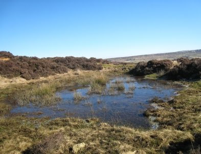
After a pleasant lunch sitting in the sun beside a winter pond, we set off on a westerly trek to reach John Breckon Road {NZ 655 067}. From here we maintained our westerley bearing and crossed Little Hograh Moor and Great Hograh Moor in order to reach a track on the east side of Holliday Hill {NZ 635 068}. We followed this in a northerly direction to Sheperd's House {NZ 630 073} and then descended down to Baysdale Beck {NZ 627 074}. Turning left, we stayed with the track, following it into Baysdale Abbey {NZ 621 067}.
We now had a good climb, passing through Baysdale Farm {NZ 616 069}, up onto the high ground on Battersby Moor - where we crossed the route of the Cleveland Way {NZ 610 069}. Using a good track from the high ground, we now dropped down through the wood to Coleson Banks {NZ 604 075} and then made our way to the village of Battersby {NZ 562 076}.
After a short tea stop on the village green, we made our way to Battersby Junction {NZ 588 072} where we turned onto a north-westerly bearing to reach Fir Tree Farm {NZ 580 080}. Staying on a bearing of 333° we trekked across the muddy fields to reach Easby {NZ 577 086}. As we continued on our north-westerly trek, we had some lovely views of the meanderings of the River Leven as we approached Woodhouse Farm {NZ 573 095} - see the picture below.

We continued across the fields to reach the minor road at {NZ 569 101} near Little Ayton. From here we had just a short trek across the fields to reach our destination in Great Ayton {NZ 563 107}.
During the course of the day we crossed over Gerrick Moor, Danby Low Moor, Westerdale Moor, Little Hograh Moor, Great Hograh Moor and Battersby Moor. Commenting on this achievement our leader commented "What more could you possibly want?".
Many thanks to JB for organising such an interesting and exciting adventure for us today. We had a really great time. Use the buttons below to see where we went, how we did and some of the sights we saw.
Labels: A-Walking: Moorland Meanderings


0 Comments:
Post a Comment
Subscribe to Post Comments [Atom]
<< Home