A-Walking: Cropton Cruiser
Our three expeditions this week (Sunday, 16th May) each took place in the Rosedale area of the North York Moors. The A-Walk set off from Rosedale Head near Ralph's Cross, the B-Walk started just south of the Lion Inn on Blakey Ridge and the C-Walk commenced at Hutton-le-Hole.
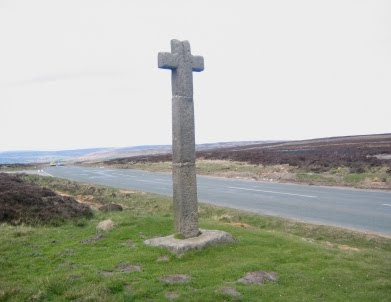
After leaving the Ralph's Cross area {NZ 677 020} (see the picture below), the intent of the A-Walk was to visit Wether Hill, Dale Head Farm, Thorgill, Rosedale Abbey, Yatts Farm and Muffles Rigg before arriving at our final destination in Cropton {SE 755 888}.

We left our drop-off point near Ralph's Cross at about 10.45 am. There were six people in the group: JB, PB, KF, AM, LM and JP. PB led the walk.
From the road junction at Rosedale Head we followed the road in an easterly direction until we reached White Cross. Turning right we made our way south to Wether Hill {NZ 682 017}. Now using an easterly bearing we navigated our way across the heather back to the road at {NZ 685 017}. After crossing the road we followed a line of very nicely painted ('white-topped') boundary markers over the moorland until we reached a south-going footpath at {NZ 698 010}.
Leaving the road on a southerly bearing we made our way to Sturdy Bank and descended down to the dismantled railway track at {SE 698 998}. Crossing this, we continued our descent to Dale Head Farm {SE 695 992}. From here we followed Dalehead Road in a southerly direction until we reached the road junction just beyond Red House Farm {SE 696 988}. Turning right we made our way in a westerly direction towards Moorlands Farm {SE 691 989}. Just before the farm we turned left onto a gated track - Daleside Road (Track).
We followed the track in a south-easterly direction to Thorgill {SE 707 965} and then took a footpath across the fields at {SE 709 963}. Rejoining Daleside Road at (SE 714 963} we continued along it in a south-easterly direction, passing Thorgill House {SE 717 959} and Hobb Farm {SE 718 958} on our right. After passing the second of these landmarks, we turned left and followed a footpath across a field to reach a footbridge at {SE 721 959}. We crossed the River Seven and sat in a sunny spot on its eastern bank for a short lunch stop (SE 721 959}.

From our lunch-stop location we walked into Rosedale Abbey {SE 724 959} - passing through the church-yard as we went (see the above picture). With the Abbey Teashop on our left, we made our way towards Alder Carr Lane where we turned right - passing over the River Seven using the road bridge at {SE 724 957}. We now followed a footpath uphill across the fields to reach the entrance to the golf course on Daleside Road (SE 722 955}.
Turning left along the road we made our way to the road junction at {SE 723 954}. Keeping the hotel on our right, we headed south along a good track towards Newlands Farm {SE 725 952}. We stayed with this track until we reached {SE 731 945} (just before Hollins Farm) where we turned left onto a downhill footpath. This took us to a bridge over the River Seven and then led us uphill to Yatts Farm {SE 736 951}. As we approached the farm we found that some 'unofficial' footpath diversions had been put in place here.
After crossing Pry Hills Lane we climbed up towards Allotment Farm {SE 740 951} where we found that more path re-routing had been put in place. However, these were official and were appropriately sign-posted with footpath markers. From the farm access road at {SE 742 948}, and subsequent to a minor navigational error, we navigated a route through the woods to reach Hancow Road at {SE 748 944} where we paused for a short 'drink stop'.
Moving off in a north-easterly direction, we trekked through a wonderful wooded area to reach a minor road at Rock House {SE 754 948}. Following the road in a southerly direction, we progressed along it until we reached a road junction at {SE 757 941} where we turned left. We now had a very steep descent towards Hartoft Beck {SE 759 942}. Just before the river we turned right and made our way to Muffles Bridge where we stopped for a short tea stop {SE 760 941}.
On leaving the tea-stop venue, we made our way to Low Muffles where we turned left at {SE 761 940} and climbed up through the forest to reach a very broad forestry track on Muffles Rigg {SE 766 940}. Turning to our right, along the track, we followed this in a southerly direction to Sutherland Road {SE 765 919}. We maintained our southerly trek until we came to a track junction at {SE 767 907} where we made a right turn. We maintained our new bearing of 262° for about 570 yards and then, turning left, returned to our southerly trek. This took us over Sutherland Beck {SE 762 904} and up to Fall Rigg {SE 762 900}.
At {SE 762 899} we changed our bearing to take us in a south-westerly direction into our final climb of the day at Cropton Banks. We joined High Lane at {SE 759 896} near the northern end of Cropton. From here we had an easy walk through the village in a southerly direction to reach our coach, and subsequently, the local hostelry {SE 755 888} - see the picture below.

We had an interesting and exciting adventure today. Despite one or two very minor navigational slips and re-routes, we had a really great time.
Use the buttons below to see where we went, how we did and some of our pictures.
Labels: A-Walking: Cropton Cruiser


0 Comments:
Post a Comment
Subscribe to Post Comments [Atom]
<< Home