B-Walking: Buckden's Blissful Beauty
Our three expeditions this week (Sunday, 8th August) each took place in the Upper Wharfedale area of North Yorkshire. The A-Walk set off from Buckden, the B-Walk started at Starbotton and the C-Walk commenced at Kettlewell. All three walks finished at Buckden.
After leaving Starbotton {SD 952 748}, the intent of the B-Walk was to visit Starbotton Fell, Buckden Pike, Cow Close, Cray, Yockenthwaite and Hubberholme before arriving at our final destination in Buckden {SD 941 772}.
We left our drop-off point at about 11.15 am. There were eleven people in the group: AB, PB, MC-1, MC-2, KF, WF, FH, JH, MaH, MeH and SS. MC-1 and MC-2 led the walk.
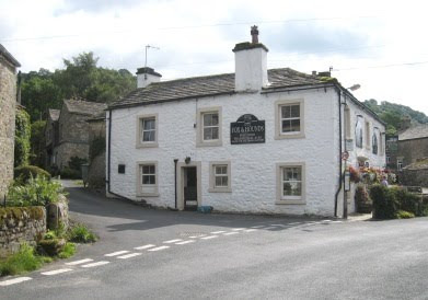
We set off in an easterly direction along the narrow road that passes along the side of the Fox and Hounds hostelry in Starbotton - the road going to the left in the picture below.

Almost immediately after passing the inn, we turned left and crossed a road bridge that took us over Cam Gill Beck. After an initial zig-zagging uphill, we climbed in a northerly direction to the footpath junction at {SD 953 753}. Taking the path on our right, we continued to climb in a north-north-easterly direction to reach Walden Road {SD 956 765}. Now changing to a north-easterly bearing, we continued our uphill trek to reach Starbotton Fell.
Using the boundary wall at {SD 965 776} as a shelter from the wind, we stopped for a short lunch break. From here, we continued to climb - uphill over the peat hags - until we reached the Memorial Cross {SD 962 778} at the southern-most tip of Buckden Pike.

Heading north along the high ground, we continued our trek to the trig point at the northern end of Buckden Pike {SD 960 787}. At this point I wandered off (with the leaders' permission) to take a photograph in a nearby neighbouring grid-square.
We descended from the high ground in a westerly direction to Cow Close {SD 947 788}. A further height reduction took us down to Buckden Rake {SD 941 784}. Then, following the course of the public footpath, we navigated a route to the minor road (Park Lane) at Cray {SD 94220 79217}.
Continuing in a westerly direction, we followed the public footpath in a westerly direction to Crook Gill {SD 934 791}. Just after the footbridge we stopped at a convenient outcrop of rocks for a short tea break near Hubberholme Wood {SD 924 787}.
We continued our westerly trek to Scar House {SD 921 789} and the footbridge that lay beyond it at {SD 916 787}. Just after passing Little House {SD 910 789} we started our rocky descent down to Yockenthwaite {SD 905 791} - where we did a 'U-turn' in order to follow the route of the Dales Way.

We followed the Dales Way along the northern bank of the River Wharfe towards Hubberholme {SD 926 782}. Using the road bridge at Hubberholme, we crossed the River Wharfe and, turning left, followed the minor road (Dubb's Lane) to {SD 93225 77960}. At this point we turned left, leaving the road, and followed the public footpath (and the Dales Way) in a south-easterly direction to Buckden {SD 941 772} - see the picture below.

Many thanks to Malcolm and Marjorie for organising such an interesting and exciting adventure for us today. I think we all had a really wonderful time exploring the blissful beauty of the Buckden area of Upper Wharfedale. Of course, we are also grateful to you for changing the route of the walk in order to minimise the extent of the bogs that we had to negotiate.
Use the buttons below to see where we went, how we did and some of the sights we saw.


0 Comments:
Post a Comment
Subscribe to Post Comments [Atom]
<< Home