A-Walking: Lealholm Link-up
Our three expeditions this week (Sunday, 19th September) each took place in the Danby Dale and Esk Dale areas of the North York Moors. The A-Walk set off from Charltons, the B-Walk started at Brown Hill and the C-Walk commenced at Castleton. All three walks finished at Lealholm.
After leaving Charltons {NZ 645 157}, the intent of the A-Walk was to visit Brown Hill, Box Hall, High Castleton, Botton Village, Stonebeck Gate Farm and Crag Wood before arriving at our final destination in Lealholm {NZ 764 078}.
We left our drop-off point at about 10.20 am. There were four people in the group: PB, JH, CL and AM. JH led the walk.
We left our drop-off point near Charltons in quite heavy rain - as can be seen from the road-side puddles in the following picture.

We went along the A171 road in a south-easterly direction to reach the road junction at {NZ 647 155}. Turning left, we made our way along Margrove Road to a footpath on our right at {NZ 650 155}. We followed this in a southerly direction to re-join the A171 road near Aysdale Gate {NZ 651 148}. From here we climbed up onto Woodhill Gill Head and then joined the Quakers' Causeway on Stanghow Moor.
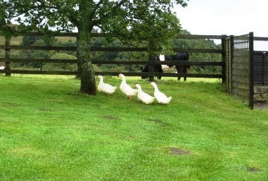
Following the Causeway in a southerly direction, we made our way to Brown Hill {NZ 670 117} and onwards over the moors to the minor road at Sand Hill {NZ 667 106} just above Commondale. We now descended across the fields in a southerly direction to join a good track at {NZ 667 101}. Turning left, we trekked along this track to Box Hall {NZ 677 090} where we turned right. After crossing the railway track and Commondale Beck, we climbed up the west side of the dale to reach Scale Foot {NZ 676 085} - where even the geese were sheltering from the rain!

After leaving the farm, we dropped down to the footbridge over the River Esk at {NZ 677 082} and then climbed up to High Castleton. From her we followed a public footpath at {NZ 683 078} that took us down-hill to Didderhowe Farm {NZ 685 075}.
Heading in a southerly direction, we made our way along Danby Dale to Holly Lodge Farm {NZ 685 064} where we stopped for a short lunch break. Fortunately, the rain held off during our stop and we had some good views of Castleton, Danby Church and Ainthorpe Rigg.
Continuing down the Dale, we reached Stormy Hall {NZ 688 044} where we turned left and descended along the road to the Weslyan church in Botton {NZ 692 044}. From here we had a good climb up through the village to the moorland road near Wolf Pitt {NZ 705 036}. Turning left along the moorland road, we headed off in a north-easterly direction to find a public footpath on our right at {NZ 710 044}. This took us downhill - passing Round Hill on our left {NZ 717 047} (see the following picture) - to reach another moorland road at Fairy Cross Plain {NZ 718 049}.

Turning left, we used the moorland road in order to make our way to Stonebeck Gate Farm {NZ 714 052}. On reaching the farm, we turned right onto a good track and followed this in a north-easterly direction towards Forester's Lodge {NZ 720 058}. Continuing on this bearing, we made our way towards Crag Farm {NZ 728 068}.
Just before reaching the farm, we turned onto an easterly bearing and navigated a route through Crag Wood - making our way to a farm track at {NZ 736 068}. After making a sharp U-turn, we now made our way to the minor road at {NZ 735 072} where we turned right onto an east-south-easterly bearing. Following the road to {NZ 738 071}, we turned left onto a footpath that took us in a northerly direction to the railway crossing at {NZ 740 076} and the minor road at {NZ 740 078} - just to the east of Houlsyke.
Turning right along the road, we continued on an east-south-easterly bearing to the public footpath at {NZ 74567 07705}. At this point we swung left onto an east-north-easterly bearing. Following the footpath across the fields, we passed High Park Farm {NZ 752 079} on our right and Park Wood {NZ 756 081} on our left. We then climbed up onto Elm Ridge to reach the path junction at {NZ 759 082}. Changing to a south-easterly bearing, we now followed a farm track to Lealholm railway station. After crossing the railway track, a downhill path led us into the centre of the village where our coach was waiting to take us home. By now, the weather had shown a remarkable improvement.

Many thanks to JH for organising such an interesting and exciting adventure for us today. We had a really great time - despite the inclement weather earlier in the day.
Use the buttons below to see where we went, how we did and some of the photos.
Labels: A-Walking: Lealholm Link-up


0 Comments:
Post a Comment
Subscribe to Post Comments [Atom]
<< Home