C-Walking: Sedbusk Surprises
Our three expeditions this week (Sunday, 23rd May) should have taken place in the Ribblesdale area of North Yorkshire within the Yorkshire Dales National Park. Unfortunately, as a consequence of a motor-cycle accident on the B6255 road (see here), our route from Hawes to Ingleton was closed - thereby preventing us from getting to the starting points for our walks. These therefore had to be cancelled. Instead, we had to organise three impromptu 'surprise' walks from Hawes.
After leaving Hawes {SD 874 898}, the intent of the C-Walk was to visit Sedbusk, North Rakes Hill, Pike Hill, Shivery Gill, High Shaw and Hardraw before returning to our final destination in Hawes {SD 876 898}.
As it was now approaching mid-day, before setting off on our expedition we decided to take a short lunch break in the playground/park area in the east end of Hawes {SD 874 897}. There were some convenient park benches here and this also gave the leader a few minutes to plan out the afternoon's activity.
After lunch, we set off from our starting point at about 12.15 pm. There were twelve people in the group: PB, VF, JH, KH, DK, FM JM, CR, RR, BW and LW. PB led the walk.

From the A684 road (see the picture above) we set off in a northerly direction along Brunt Acres Road - following the route of the Pennine Way (PW). We crossed the River Ure using the road bridge at {SD 876 903} - Haylands Bridge. At {SD 877 905} we left Burnt Acres Road by following a north-easterly footpath on our right. This took us across the field, over a quaint stone footbridge and then uphill to a minor road at {SD 880 908}. From here we continued on our north-easterly bearing until we reached Sedbusk Lane at {SD 883 910}. Turning left we continued uphill along the lane into the small village of Sedbusk {SD 883 911}.
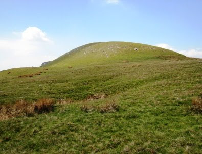
Leaving the village on a north-easterly trek, we made our way uphill along Shutt Lane to reach {SD 889 916}. As we progressed up the route of the walled bridleway we had some tremendous views of the Hawes area to the south of us. We also had some good views of the impressive scars that lay ahead of us (to the north): High Clint (to our left) and Little Fell Clint (to our right). Leaving {SD 889 916} we headed north (again uphill) to reach a gated wall at {SD 889 918}. Our track now zig-zagged a little and then climbed up onto the high ground near Little Fell Clint {SD 889 921}. Returning to our northerly bearing, we continued our trek to reach {SD 889 924} at the southern end of Abbotside Common. As we moved north, we had some good views of Smuker Hill {SD 887 921} on our left - see the picture below.

Having reached Abbotside Common, the major part of the climbing was now over. We were now able to enjoy some very pleasant cool breezes as we walked north. At {SD 889 924} we turned left and went along a good track in a westerly direction. This led us into the final (gentle) climb of the walk - up onto North Rakes Hill {SD 883 924}. We paused here to admire the views and also take a short drink stop. Looking in a north-north-easterly direction, we could see the trig point on Great Shunner Fell.
Continuing our trek in a westerly direction we made our way across the high ground towards the cairns on High Clint. At {SD 875 924} we changed to a north-westerly bearing and moved along the contours to reach the two cairns near Pike Hill {SD 869 931}. There were some quite spectacular views to the west and south-west from here. Maintaining our north-westerly bearing, we followed a poorly defined footpath to reach Shivery Gill {SD 868 935} - see the following picture.

About 85 yards further north we turned left and followed the footpath downhill to join a minor road at {SD 865 936}. Turning left, we followed this downhill (in the direction of Hawes) until we reached a gate on our right at {SD 866 926}. We used this to gain access to a convenient field where we stopped for a short tea break. Again, from our vantage point, we had some good views of the Hawes area below us.
After our tea stop, we continued downhill along the road to find a footpath on our right at {SD 867 924}. Taking this path we continued downhill across the fields towards a small stream at {SD 865 922} near Strands. The path now took us in a south-easterly direction (passing a caravan site on our right) to reach the road at {SD 869 919} near High Shaw. We stayed with the road for about 120 yards and then turned left along a footpath at {SD 869 918} that took us to a path junction at Low Shaw {SD 871 917}. Now turning onto a bearing of 207°, we dropped down to the road near Simonstone {SD 871 916}. Continuing on a bearing of 218° (roughly, south-west) we made a steep descent down to the village of Hardraw {SD 867 912} where we stopped for a short late-afternoon refreshment break at the Green Dragon hostelry.
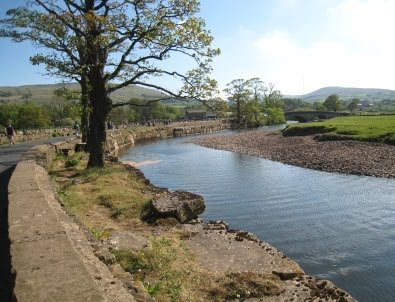
The final part of our walk took us from Hardraw along the PW in a southerly direction towards and into Hawes. As we went south along Burnt Acres Road, we had some picturesque views of the River Ure (as depicted in the scene below).

We continued along the PW and Burnt Acres Road towards its junction with the A684 road. Just before the junction we turned left into the car park and found our coach waiting for us at the far end.
Despite the unexpected and surprising events of the early part of the day, we managed to organise an interesting and exciting adventure centred around the Hawes area. We had a really great time - of course, the wonderful weather helped.
Use the buttons below to see where we went, how we did and some of the pictures.
Labels: C-Walking: Sedbusk Surprises


0 Comments:
Post a Comment
Subscribe to Post Comments [Atom]
<< Home