Sunday Walking to Kepwick
On Sunday, 3rd October, the Stockton Rambling Club will have three walks in the south-western area of the North York Moors. All walks will finish in Kepwick {SE 468 909} - see the following maps.

Crown Copyright (2010). All rights reserved. Licence No. 100046831.
Produced using Anquet Maps.
Produced using Anquet Maps.
The A-walk will start at Clay Bank {NZ 572 034} and will take in a section of the Cleveland Way, Scugdale, Sheepwash and Chequers.
The B-walk will commence at Chop Gate {SE 558 993} and will visit Arnsgill Ridge, Harker Gates and Thorodale.
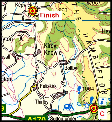
The C-walk will set off from Sutton Bank {SE 515 831} and will take in a section of the Cleveland Way, Boltby, Kirby Knowle and Cowsby.
This is a Route 1 coach pick up (Billingham: 9.30 am, Stockton: 9.45 am and Acklam: 10.00 am).
Labels: Sunday Walking to Kepwick
posted by philbee @ 14:32
0 Comments
![]()


0 Comments:
Post a Comment
Subscribe to Post Comments [Atom]
<< Home