Mid-Week Walking - Two Walks (Nunthorpe and Danby)
During the week beginning 6th April, Stockton Rambling Club will have TWO mid-week walks available. One is an evening walk and the other is a day walk.
The evening walk is on Wednesday, 8th April and will start at 7.00 pm from Nunthorpe Church Car Park {NZ 540 140} - see the map below.
This walk will be not be longer than 6 miles. Please ring 01642-715773 for more details.
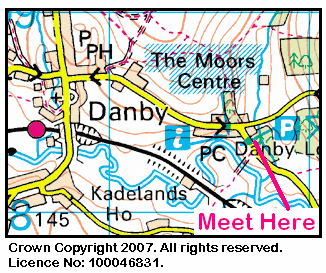
The day walk is on Thursday, 9th April. It will start at 10.30 am from the Moors Centre at Danby Lodge {NZ 716 084} - see the map below.
The length of this walk will be up to 10 miles. Please telephone 01845-526566 for more details.
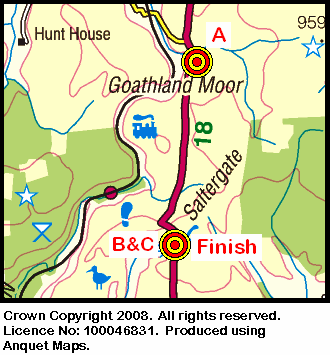
On Sunday, 5th April, the Stockton Rambling Club will have three walks in the Eastern area of the North York Moors. All walks will finish at the Hole of Horcum {SE 852 936} - see the following map.
The A-walk will start at Eller Beck Bridge {SE 858 983} and will take in Simon Howe, Farwath, Bride Stones and Old Wife's Way.
The B-walk will follow a circular route commencing at the Hole of Horcum and will visit Levisham Bottoms, Farwath and Bride Stones.
The C-walk will also follow a circular route from the Hole of Horcum and will pass through Levisham, Bride Stones and Old Wife's Way.
This is a Route 1 coach pick up (Billingham: 9.30 am, Stockton: 9.45 am and Acklam: 10.00 am).
We set off from Scaling Dam Farm (see the picture below) at about 10.45 am. There were 10 of us in the group: LB, PB, RB, KF, AJ, WM, MS, MuS, JY and PY. LB, PB,WM, MS and PY and PY were in shorts. PB led the walk.
We set off in a northerly direction across the fields to reach the small village of Scaling {NZ 743 128}. At Brookridge Farm we turned east and headed for Roxby Low Moor and Stang Howe. At Brookridge Farm we saw some llama-like creatures (I don't know if they were llamas or alpacas) and at Stang Howe there was a magnificant array of peacocks displaying their feathers.
We continued on our easterly trek to {NZ 780 139} - a point just north of Newton Mulgrave Woods. We now took a north-easterly bearing and headed for Newton Mulgrave - having decided to miss out Ellerby. From here we made a north-westerly trek to Borrowby Dale - crossing the stream at the footbridge {NZ 781 165}. Now heading north, we passed by Plum Tree Farm on our right and then dropped down to the footbridge at {NZ 780 176}. Our route now took us to Dalehouse.
After crossing the A174 road to reach Cowbar Farm, we joined the Cleveland Way (CW) at Cowbar Lane {NZ 778 188}. Turning left, in a westerly direction, we followed the CW up the coast to Boulby and Skinningrove. We continued along the coast keeping to the route of the CW. We left this at {NZ 699 213}, turning left to pass over Warsett Hill. We rejoined the CW near the Ship Inn in Saltburn (see picture below) and followed it uphill to the end of our walk.
Throughout the today's walk we experienced quite strong winds. These made the trek along the coast more difficult than it might have otherwise been. Fortunately, we were able to find some shelter for our lunch break (in Borrowby Dale) and our tea-stop (in Skinningrove).
Despite our exposure to strong head-on winds during the day, we arrived at our coach in Saltburn at about 16.10; this gave us about 35 minutes in order to partake of refreshments!
Click the button below to see the GPS tracklog of where we went and the walk statistics.
I managed to take a few quick snaps during today's expedition; click on the button below to take a look at these.
The were no 'untoward' events to report from today's walk!
On Sunday, 29th March, the Stockton Rambling Club will have three walks in the Weardale area of County Durham. All walks will start from Stanhope {NY 995 392} and will finish in Frosterley {NZ 030 369} - see the following map.
The A-walk will take in Aller Gill Cottage, Round Hill, Carrs Top, Outberry Plain and Pawlaw Pike.
The B-walk will visit Parsons Byers, Fine Rigg, Pawlaw Pike and Five Pikes.
The C-walk will pass through Parsons Byers, Pye Close, Allotment House and West Biggins.
This is a Route 3 coach pick up (Acklam: 9.30 am, Stockton: 9.15 am and Billingham: 10.00 am).
On Thursday, 26th March, Stockton Rambling Club have a mid-week walk in the Helmsley area of North Yorkshire. Please meet at 10.30 am at Helmsley Car Park {SE 609 838} - see the following map.
The walk will not be longer than 10 miles. For further details ring 01642-656273.
There were eight of us on the A-Walk today: LB, PB, CH, WM, MS, MuS, PY and JY. PY was in shorts; PB led the walk.
We set off in glorious sunshine at about 10.45 am from {NZ 675 013} - a point just south of Ralph's Cross on the minor road between Castleton and Hutton-le-Hole (our ultimate destination).
From the point illustrated in the above photograph, we took a westerly bearing (following the boundary stones) across Farndale Moor to reach the old dismantled railway track. We descended from here to Esk House {SE 649 996} before making the first (and hardest) climb of the day - up onto Rudland Rigg {SE 635 986}. We then dropped down to Cow Syke {SE 625 981} at the northern end of Bransdale. We had our lunch stop at Bransdale Mill.
After lunch we had our second climb of the day - up onto the eastern edge of Bilsdale East Moor {SE 610 962} - just east of Botany Bay. Our route now took us south to Pockley Moor and Hanging Stone {SE 624 923}. Just before Rollgate Bank {SE 629 912} we swung east in order to cross Otterhills Common. After passing through Otterhills we had a short tea-stop and then continued our easterly trek across to Stonely Woods {SE 656 913}, Grays {SE 667 914} and Faddell Rigg {SE 681 909}.
We crossed the River Dove at the Mill {SE 687 909} and then headed east towards Grouse Hall and Hutton-le-Hole {SE 705 901}. As a result of the very muddy section just before the end of the walk, some of us paddled in the local stream in order to clean our boots before getting on our coach.
Click the button below to see where we went and the walk statistics.
During the walk, I made a few navigational 'slips' which caused the actual route that we took to deviate (slightly) from the planned route. Click the button below to see an analysis of the 'minor mistakes' that I made.
Thankfully, none of my blunders were 'fatal'! Indeed, we arrived at our destination about 10 minutes before 'close of play'.
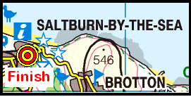
On Sunday, 22nd March, the Stockton Rambling Club will have three walks in the Noth-Eastern area of the North York Moors. All walks will finish in Saltburn {NZ 666 214} - see the following map.
The A-walk will start from Scaling {NZ 755 128} and will take in Stang Howe, The Dales, Cowbar Lane and the Cleveland Way.
The B-walk will commence at Ellerby Moor and will visit Newton Bank, The Dales, Staithes and the Cleveland Way.
The C-walk will set off from Staithes {NZ 780 185} and will follow the Cleveland Way in a northerly direction.
This is a Route 1 coach pick up (Billingham: 9.30 am, Stockton: 9.45 am and Acklam: 10.00 am).
We set off at about 11.00 am in a southerly direction from Middleham {SE 128 878}. There were eleven of us in the group: PB, KF, CH, JJ, JP, SR, MS, GT, JY, PY and Rob. JJ led the walk.
On leaving Middleham, we passed the castle on our right as we headed south to Cover Banks {SE 127 867}. Here we swung right onto a westerly bearing to follow the River Cover (see picture below) to our crossing point at Hullo Bridge {SE 118 865}.
Continuing in a southerley direction we reached the minor road at Braithwaite Hall where we turned right. We left this at {SE 114 859} to follow a path on our left which took us to Caldbergh {SE 094 850}. We had a little difficulty finding the bridge over Caldbergh Gill, so, we decided to do a 'conventional A-walk' crossing. Then, as often happens, after we had crossed the stream, we looked back only to see clearly the bridge that we previously could not find!
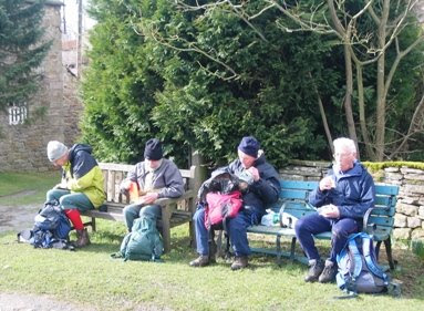
We continued on our SW bearing up Coverdale, walking on a route that (more or less) followed the River Cover (on our right) to reach the delightful village of West Scrafton {SE 074 836} where we had lunch. Some of us had very comfortable seats ...
while others had to 'rough it' ...
The hard work started after our lunch stop when we had to climb up onto West Scrafton Moor {SE 078 811}. As we reached the top, there were patches of snow on the ground and we had to contend with strong 'head-on' winds and a heavy hail-stone storm. We were now heading roughly south and continued in this direction until we reached Steel House Gill {SE 093 797} where we picked up a good track to the east.
We turned onto this track (which followed the course of the River Burn) and stayed on it until we reached High House Farm {SE 121 806}. From here we took the road to Colsterdale and onwards to {SE 144 814} where we picked up a path on our left. This led us to our second good climb of the day. It took us up onto Agra Moor {SE 137 827}. As we climbed, we passed between Slipstone Crags (to the east) and Brown Beck Crags (to the west).
Continuing in a northerly direction, we had a short gentle climb onto the eastern edge of Witton Fell. Once this climb was over, we had a good down-hill run ('metaphorically speaking') into East Witton {SE 145 860}. As we made our descent, it was snowing quite heavily.
When we arrived at the village, some of us managed to get into the local pub for some quick refreshments before boarding our faithful coach for the trip back to Middlesbrough.
Martin-S took some photos during the expedition. He has emailed me some copies of these. Click on the button below to see them.
Click on the button below in order to see the GPS tracklog of where we went and the height profile of our walk.
Many thanks to Jill for a tremendous walk and a wonderful day. We all enjoyed our expedition and had some really great fun.
On Wednesday, 18th March, Stockton Rambling Club have a mid-week walk in the Longnewton area of Stockton-on-Tees. Please meet at 10.30 am at the Vane Arms {NZ 378 161} - see the following map.
The walk will not be longer than 5 miles. For further details ring 07892-908201.
We are just into March 2009 and Easter is approaching very rapidly. There is no doubt about it: Spring is on the way. A few days ago I saw my first 2009 daffodil. So, I thought I would post up a few pictorial memories from last year's daffodil season.
And just to finish off, here is a short video clip of a host of daffodils tossing their heads in the wind:
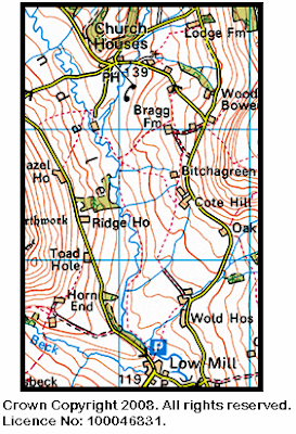
At this time of the year there are often lots of sponsored 'Daffodil Walks' taking place in aid of the Marie Curie Cancer Care movement. Obviously, this is a tremendously good cause - but don't forget our own local 'Daffodil Walk' in Farndale from Low Mill {SE 672 952} to Church Houses {SE 669 975} - see the following map.
Further details on the Daffodil Walk can be found here.
On Sunday, 15th March, the Stockton Rambling Club will have three walks in the Western Region of the North York Moors. All walks will finish in Hutton-le-Hole {SE 705 902} - see the following map.
The A-walk will start near Ralph Cross {SE 678 997} and will take in Esk House, Hanging Stone, Otterhills and Faddell Rigg.
The B-walk will commence at the Lion Inn {NZ 675 013} and will visit Esk House, Fox Hole, Rudland Rigg and Farndale.
The C-walk will set off from the Lion Inn and will pass through Church Houses, Farndale, Lowna Bridge and Grouse Hall.
This is a Route 1 coach pick up (Billingham: 9.30 am, Stockton: 9.45 am and Acklam: 10.00 am).
On Thursday, 12th March, Stockton Rambling Club have a mid-week walk in the Osmotherley area of the North York Moors. Please meet at 10.30 am at the Queen Catherine Hotel {SE 455 972} - see the following map.
The walk will not be longer than 10 miles. For further details ring 01642-350504.
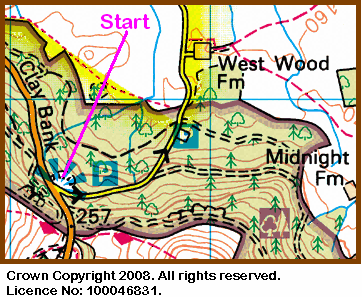
It was a lovely sunny morning on Sunday, 1st March when twenty-three of us (the B-Walkers) set off at 10.30 am from Clay Bank car park {NZ 572 035} - see details below.
Our destination was Guisborough - in under 14 miles - and taking in Battersby and Kildale; PB led the walk.
We set off in an easterly direction along a well-defined forest track (passing through Greenhow Plantation) to reach Clogger's Hall {NZ 589 029}.
From here we headed north to reach Ingleby Manor {NZ 586 056} and then followed a north-easterly bearing to arrive at Bank Foot {NZ 593 016} where some people had to queue to use the stile.
Just beyond Bank Foot we found a useful hedge-row {NZ 596 067} beside which we sat for our well-earned lunch stop.
After lunch we pushed on to reach the small villages of Battersby {NZ 597 076} and Kildale {NZ 608 094} where we joined the Cleveland Way (CW). After Kildale we had our first (of three) major ascents (322 feet) from the railway bridge (near Kildale station) through Bankside Farm up onto the eastern edge of Coate Moor {NZ 605 105} where we left the CW.
Now we had an easy, pleasant and picturesque descent to Lonsdale Beck. The following photograph shows the view looking north to Oak Tree Farm.
Now we had our second major climb of the day (381 feet) up onto Percy Cross Rigg {NZ 607 118}. We had a short tea stop at the old military 'pill box' at NZ 602 124.
At Hutton Moor we re-joined the CW and followed its route to Highcliff Nab (our third climb - 220 feet) and onwards in an easterly direction through Highcliff Woods and Guisborough Woods. We left the CW at {NZ 621 144} - heading north to drop down to Belman Bank where we followed a good track and then a road into Guisborough where our coach was waiting.
On Sunday, 8th March, the Stockton Rambling Club will have three walks in the Wensleydale area of North Yorkshire. All walks will finish in East Witton {SE 144 860} - see the following map.
The A-walk will start at Middleham {SE 127 877} and will take in Caldbergh, Colsterdale and Agra Moor.
The B-walk will commence at Middleham and will visit Hullo Bridge, Caldbergh Moor and Agra Moor.
The C-walk will set off from Leyburn {SE 111 905} and will pass through Capple Bank, Malmerby and Caldbergh.
This is a Route 2 coach pick up (Billingham: 9.30 am, Acklam: 9.45 am and Stockton: 10.00 am).