Thursday 29 April 2010

A-Walking: Helmsley Highlights

Our three expeditions this week (Sunday, 25th April) each took place in the Bilsdale area of North York Moors. The A-Walk set off from Chop Gate, the B-Walk started at Low Ewe Cote and the C-Walk commenced at Oscar Park Farm.

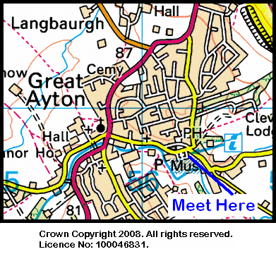
After leaving Chop Gate {SE 559 994}, the intent of the A-Walk was to visit Stump Cross, Hanging Stone, Howl Wood and Riccal Dale before arriving at our final destination in Helmsley {SE 610 838}.

We left our drop-off point in the car park (see the picture below) at about 10.30 am. There were eleven people in the group: JB, JPB, PB, RB, KF, JH, CL, KL, AM, LM, JT. RB led the walk.

Chop Gate car park
After crossing the B1257 road, we trekked in an easterly direction along the access track to William Beck Farm {SE 570 994}. Continuing in an east-south-easterly (ESE) direction we crossed Black Intake and ascended into Tripsdale {SE 582 989}. From here we had a good climb up onto Slape Wath Moor, which we crossed on an ESE bearing, in order to reach Stump Cross {SE 607 982}.

Turning right, we continued in a southerly direction across Bransdale Ridge towards the minor road at {SE 610 963}. Just before reaching the road we decided to stop for lunch. Because there was a strong cold wind blowing, we sought refuge in some nearby grouse butts at {SE 608 963} and {SE 609 963}.

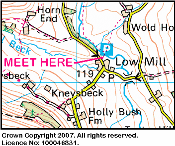
After lunch, we followed the road to {SE 613 953} where we joined a footpath that took us south across Pockley Moor to reach Hanging Stone {SE 623 923} and a near-by tarn (see the picture below).

Tarn
Just after Hanging Stone, we turned onto a south-easterly bearing and made our way to Throstle Nest {SE 617 907} and Lund Farm {SE 613 905}. We continued on this bearing to reach {SE 612 902} and then switched to a south-easterly bearing which we used in order to navigate to Howl Wood Farm {SE 617 893} and, subsequently, Hasty Bank Farm {SE 625 884}. From here, we made our way into Riccal Dale Wood {SE 624 883}.

Continuing on our southerly bearing we made our way through Riccal Dale until we reached the junction of two tracks (High Tun Way and Low Tun Way) {SE 622 875}. We stayed with Low Tun Way and eventually emerged from the forest on the west side of the dale at {SE 625 859}. Our path now took us along the western edge of the forest to Rea Garth Farm {SE 625 858}.

We continued along the edge of the forest until we reached a path junction at {SE 630 847}. Turning right, we made our way to Reagarth Farm {SE 627 845} and then made our way across the fields to the Youth Hostel in Helmsley {SE 616 840}. We then walked through the town in order to reach tha car park {SE 610 838} where our coach was waiting for us.

Helmsley
Many thanks to RB for organising such an interesting and exciting adventure for us today. We had a really great time. Use the buttons below to see where we went, how we did and some of the photos.


Labels:

Wednesday 28 April 2010

Early-May Mid-Week Walking

During the week beginning 3rd May, Stockton Rambling Club will have TWO mid-week walks available. One is an evening walk and the other is a day walk.


The evening walk is on Wednesday, 5th May and will start at 7.00 pm from The Black Horse in Swainby {NZ 477 021} - see the map below.

Black Horse, Swainby Map
Crown Copyright (2010). All rights reserved. Licence No. 100046831.
Produced using Anquet Maps.

This walk will be not be longer than 6 miles.
Please ring 07892-908201 for more details.


The day walk is on Thursday, 6th May. It will start at 10.30 am from the Tourist Information Centre in Great Ayton {NZ 563 107} - see the map below.

Map of Great Ayton Area
The length of this walk will be up to 10 miles.
Please telephone 01642-715773 for more details.


Labels:

Tuesday 27 April 2010

Sunday Walking to Kettlewell

On Sunday, 2nd May, the Stockton Rambling Club will have three walks in the Wharfedale area of North Yorkshire. All walks will finish in Kettlewell {SD 971 723} - see the following map.

Map of the Hebden-Kettlewell area
Crown Copyright (2010). All rights reserved. Licence No. 100046831.
Produced using Anquet Maps.

The A-walk will start at Hebden {SE 025 631} and will take in Grassington, Kelbar, Great Whernside and Providence Pot.

The B-walk will also commence at Hebden and will visit Grassington, Conistone Dib and Capplestone Gate.

The C-walk will set off from Grassington {SE003 641} and do part of the Dales Way and then pass through Conistone Dib before re-joining the Dales Way.

This is a Route 1 coach pick up and it is also an early start (Billingham: 9.00 am, Stockton: 9.15 am and Acklam: 9.30 am).


Labels:

Friday 23 April 2010

A-Walking: Reeth Roundabout

The location of our three walks this Sunday (18th April) was 'spread out' over two beautiful North Yorkshire dales: Wensleydale (where our walks began) and Swaledale (where our adventures finished). Both the A-Walk and the B-Walk set off from the village of Wensley (see the picture below) while the C-Walk commenced at Leyburn. All walks finished in the lovely town of Reeth {SE 038 993}.

Wensley
After leaving Wensley {SE 092 897}, the intent of the A-Group's expedition was to visit Castle Bolton, Dent's Houses, Apedale Head, Isles Bridge and Surrender Bridge before arriving at our final destination in Reeth.

We set off from our drop-off point on the A689 road in Wensley {SE 091 896} at about 11.08 am. There were eight people in the group: PB, RB, KF, JG, CH JJ, LM and JP. JJ led the walk.

Leaving the village in a westerly direction, we entered Wensley Park and followed the access road to Middle Lodge {SE 083 896}. Continuing along the road we passed the very impressive Bolton Hall on our right {SE 075 897}. Beyond the Hall, the road 'deteriorated' to a track which took us into West Wood {SE 071 896}. As we passed through the wood, we had some good views of the River Ure on our left.

We left the wood at {SE 059 901} and followed the public footpath across the fields in a north-westerly direction to reach the village of Redmire {SE 046 912}. After passing through the village, we crossed Apedale Beck at {SE 043 914} and then continued on our north-westerly trek to reach Castle Bolton {SE 036 919}. As we approached the village we had some magnificant views of the castle.

Bolton Castle
From the village we took a path at {SE 035 919} that led us into the first major climb of the day. Heading in a north-north-westerly direction we had a long and arduous climb upon onto the top of Black Hill {SE 031 934}. Once we were on the high ground, we had a pleasant trek along a track that would have taken us to Dent's Houses {SE 030 942}. However, the walk leader decided that she would 'cut a corner' and, in so doing, took us across some boggy, rough terrain (see the red line in the map section below).

Short Cut
Crown Copyright (2009). All rights reserved. Licence No. 100046831.
Produced using Memory-Map.

After crossing Apedale Beck, we joined the westerly track (Apedale Road) from Dent's Houses at {SE 027 943}. We then followed this in a westerly direction across East Bolton Moor and along the northern side of Smithy Gill. We stopped for lunch at {SE 005 952} near Apedale Head {SE 003 953}. This gave us some very impressive views of the land to the east of us.

From our lunch location we continued on a bearing of 288° to reach the old lead mine on Whitaside Moor {SD 989 956}.

Maintaining our north-westerly bearing, we descended from the high ground - now passing through a substantial area of disused mine workings as we went. We crossed High Lane at {SD 982 964} and continued our descent down to Haverdale Beck Bridge {SD 976 973} where we turned right along a minor road. After 75 yards we turned left and followed the road to Isles Bridge. As we crossed the bridge we had some good views of the River Swale {SD 977 975}.

River Swale
From the bridge we made our way to the B6270 road at {SD 977 976}. We now had our second major climb of the walk. We zig-zagged uphill in a northerly direction to reach Turnip House {SD 978 981} and, beyond this, the small community of houses at Blades {SD 980 985}.

Leaving Blades in a north-easterly (NE) direction, we continued to climb up to and across Feetham Pasture {SD 986 991}. Continuing on our NE trek, we reached a minor road at {SD 990 995}. Turning left along the road we descended down to Surrender Bridge {SD 988 999}. After using the bridge to cross Barney Beck, we stopped on the northern bank for a short tea stop.

Surrender Bridge
After our very pleasant tea break we continued in an easterly direction towards the ruined remains of the old smelting mill {SD 991 999}. We then swung onto a north-easterly bearing and made our way towards Cringley Bottom {NY 998 002}. At {NZ 002 001} we turned onto a south-easterly bearing and trekked towards Thirns {SE 011 995}. Here we joined a minor road that took us on a steep descent to the small village of Healaugh {SE 018 990}. Turning left onto the B6270 road, we followed this for about 180 yards and then turned right onto a public footpath at {SE 019 991}. This took us in a south-south-easterly direction to the northern bank of the River Swale {SE 021 988}.

Turning left along the bank of the river, we now followed a riverside footpath to {SE 028 991} near Hutton Garth. At this point we left the river and followed a field path in an easterly direction to arrive at our final destination in Reeth {SE 039 992} where we met up with our coach.

Many thanks to JJ and JG for organising such an interesting and exciting adventure for us today. We had a really great time. Use the buttons below to see where we went, how we did and some of the photographs that were taken.


Labels:

Thursday 22 April 2010

Two Late-April Mid-Week Walking Events

During the week beginning 26th April, Stockton Rambling Club will have TWO mid-week walks available. One is an evening walk and the other is a day walk.


The evening walk is on Wednesday, 28th April and will start at 7.00 pm from The King's Head at Newton-under-Roseberry {NZ 570 129} - see the map below.

Map of King's Head area
This walk will be not be longer than 6 miles.
Please ring 01642-764006 for more details.


The day walk is on Thursday, 29th April. It will start at 10.30 am from Heighington Recreation Field Car Park (opposite the school) {NZ 570 129} - see the map below.

Map of Heighington Recreation Field CP Area
Crown Copyright (2010). All rights reserved. Licence No. 100046831.
Produced using Anquet Maps.

The length of this walk will be up to 10 miles with 900 feet of ascent.
Please telephone 01740-644347 for more details.


Labels:

Monday 19 April 2010

Sunday Walking to Helmsley

On Sunday, 25th April, the Stockton Rambling Club will have three walks in the Bilsdale area of the North York Moors. All walks will finish in Helmsley {SE 608 837} - see the following maps.

Map of the Chop Gate to Helmsley area - Part 1Map of the Chop Gate to Helmsley area - Part 2
Crown Copyright (2009). All rights reserved. Licence No. 100046831.
Produced using Anquet Maps.

The A-walk will start at Chop Gate {SE 558 993} and will take in Stump Cross, Hanging Stone, Howl Wood and Riccaldale.

The B-walk will commence at Low Ewe Cote {SE 568 916} and will visit Hawnby, Dale Town, Oxpasture Lane and Rievaulx.

The C-walk will set off from Oscar Park Farm {SE 572 873} and will pass through High Baxtons Farm, Carlton Grange and Riccaldale.

This is a Route 1 coach pick up (Billingham: 9.30 am, Stockton: 9.45 am and Acklam: 10.00 am).


Labels:

Thursday 15 April 2010

A-Walking: Hambleton Highlights

Our three walks this Sunday (11th April) each took place in the western region of the North York Moors. The A-walk started at Ingleby Cross; the B-walk began at Osmotherley; and the C-walk commenced at Kepwick. All walks finished at Sutton Bank {SE 516 831}.

After leaving the road junction near Ingleby Cross {NZ 451 005}, the intent of the A-Group's expedition was to visit Cod Beck Reservoir and Oakdale and then follow the Cleveland Way (CW) long-distance footpath to High Paradise Farm. We were then to make a diversion to Boltby before rejoining the CW at High Barn and continuing on to the visitors' centre at Sutton Bank.

We set off from our drop-off point at about 10.20 am. there were 9 people in the group: JPB, PB, RB, KF, CH, MH, CL, KL and LM. CH and MH led the walk.

From our drop-off point we headed in a south-easterly direction along the access road to Arncliffe Hall {NZ 454 002}. At {SE 4553 9997} we turned left onto a forest track that took us through Arncliffe Wood in a north-easterly direction towards Cog Hole {NZ 459 002}. We continued along the forest track until we reached a footpath at {NZ 465 005}. From here we had a good climb up through the woods to reach the 'bowder stone' at {NZ 463 003} (see the picture below) and the viewing point at {SE 460 999}.

Bowder stone
We left Arncliffe Wood at {SE 461 999} and then crossed Scarth Wood Moor on a south-easterly bearing to reach the northern end of Cod Beck Reservoir {SE 468 992}. We now followed the footpath on the western bank of the reservoir in order to make our way to the dam wall at {SE 462 986}. After crossing the dam, we navigated a route through the woods near Cote Garth so as to reach Green Lane {SE 467 980}. Turning right, we trekked in a south-south-westerly direction along the lane (track) to reach a minor road at {SE 464 968} where we joined the Cleveland Way. This took us in an east-south-easterly direction to Oakdale. We passed the two reservoirs (on our right) and then had the second climb of the day: up to the car park at Square Corner {SE 480 959}.

Oakdale Reservoir
From the car park we continued on a southerly bearing, passing Hambleton End on our left. Following our climb up onto Black Hambleton, we stopped for a short lunch break at {SE 481 942}. The location at which we stopped gave us some tremendous views to the west.

Continuing along the CW, we made our way to Hambleton Street and followed this to the track junction at White Gill Head {SE 491 932} where we turned onto a southerly bearing. We kept this bearing until we reached a track junction at {SE 489 909} on Little Moor.

Staying with the CW, we moved to a bearing of 155° and made our way (via Steeple Cross {SE 495 901}) to Dale Town Common. At the track junction near Hambleton Road {SE 505 890} we turned right and passed through High Paradise Farm {SE 503 888}. We now started our descent to the low ground. We left the route of the CW at {SE 504 883} and dropped down to Low Paradise Farm {SE 502 881}.

Low Paradise Farm
Now descending in a south-westerly (SW) direction, we crossed Lunshaw Beck at {SE 501 879}. Maintaining our SW bearing, we made our way across the fields to reach a minor road at {SE 495 867}. Turning right we went up hill in the direction of Boltby. After about 145 yards we took a path on our left at {SE 495 866}. Now moving in an easterly direction, we went downhill and crossed Lunshaw Beck again at {SE 496 866}.

At {SE 499 865} we embarked on the third (and major) climb of the day. We zig-zagged up the hill to reach High Barn {SE 507 866} where we re-joined the CW. Turning right, we proceeded in a southerly direction towards Boltby Scar where we stopped, near Hambleton Mosses {SE 507 861}, for a short tea break. Sitting rather precariously on the edge of the scar, we had some spectacular views of Boltby and the surrounding area from our tea-stop location.

After tea we continued our southerly trek along the eastern side of South Woods with Hambleton Down on our left. As we went south, we had some good views of Gormire Lake (see picture below) and Whitestone Cliff.

Gormire Lake
At {SE 508 835} our track swung onto a south-easterly bearing and went along Sutton Brow until it crossed the A170 road at {SE 514 830}. At this point we left the CW and made our way to the Visitors' Centre at Sutton Bank {SE 516 831} where our coach was waiting nearby - ready to take us home!

Many thanks to CH and MH for organising such an interesting and exciting adventure for us today. We had a really great time. Use the buttons below to see where we went, how we did and some of the sights we saw.


Labels:

Wednesday 14 April 2010

Mid-April Mid-Week Walking

During the week beginning 19th April, Stockton Rambling Club will have TWO mid-week walks available. One is an evening walk and the other is a day walk.


The day walk is on Wednesday, 21st April and will start at 10.30 am from the Sutton Arms in Elton {NZ 396 172} - see the map below.

Map of Sutton Arms area
Crown Copyright (2009). All rights reserved. Licence No. 100046831.
Produced using Anquet Maps.

This walk will be not be longer than 5 miles.
Please ring 07892908201 for more details.


The evening walk is also on Wednesday, 21st April. It will start at 7.00 pm from Clay Bank car park on the North York Moors {NZ 572 035} - see the map below.

Map of Clay Bank Area
The length of this walk will be up to 6 miles.
Please telephone 01642-778247 for more details.


Labels:

Tuesday 13 April 2010

Sunday Walking to Reeth

On Sunday, 18th April, the Stockton Rambling Club will have three walks in the Wensleydale area of North Yorkshire. All walks will finish in Reeth {SE 038 993} - see the following map.

Map of the Wensley to Reeth area
Crown Copyright (2009). All rights reserved. Licence No. 100046831.
Produced using Anquet Maps.

The A-walk will start at Wensley {SE 091 896} and will take in Castle Bolton, Apedale Head, Isles Bridge and  Surrender Bridge.

The B-walk will also commence at Wensley and will visit Redmire, Dent's Houses, Greets Hill and Harkerside.

The C-walk will set off from Leyburn {SE 111 904} and will pass through Preston-under-Scar, Cogden Moor and Grinton.

This is a Route 2 coach pick up (Billingham: 9.30 am, Acklam: 9.45 am and Stockton: 10.00 am).


Labels:

Thursday 8 April 2010

Special Event: Durham Botanical Gardens

On Thursday the 15th April Stockton Rambling Club will have a trip to Durham Botanical Gardens. Following the organised tour of the gardens, there will be an optional 6 mile walk.

Please meet at 10.15 am at Howlands Farm Park & Ride (PR2) on the A177 {NZ 270 407} - see the map below.

Map of the Howlands Farm P&R area
Bookings for this event (and payment) should be sent to Bill McTimoney (01740-644347). The cost of the tour of the gardens is £5.00.


Labels:

Mid-Week Walking from Nunthorpe

On Wednesday, 14th April, Stockton Rambling Club have a mid-week walk in the Nunthorpe area of the North York Moors. Please meet at 7.00 pm at Nunthorpe Church car park {NZ 540 139} - see the following map.

Map of the Nunthorpe Church area
The walk will not be longer than 6 miles.
For further details ring 01642-715773.


Labels:

Tuesday 6 April 2010

A-Walking: Weardale Wonderland

Our three SRC walking expeditions this week (4th April) each took place in the Weardale area of County Durham. The A-Group set off from near Fir Tree on the A68 road; the B-Group made its start at Eels Bridge on the A689 road; and the C-Group set off from Wolsingham. All walks finished in Wolsingham {NZ 076 372}.

After setting off from Fir Tree, the intent of the A-Group's expedition was to visit Low Harperley, Bedburn, Potato Hill, Pikeston Fell, White Kirkley and Frosterley before arriving at our final destination in Wolsingham.

We set off from our drop-off point on the A68 {NZ 138 347} at about 10.45 am. There were five people in the group: JB, JPB, KF, CH and PB. PB led the walk.

Leaving the A68 road on a south-westerly bearing, we made our way to Hollin Hall {NZ 136 345} and then Wadley Farm {NZ 132 339} where we joined the Weardale Way (WW) - see the picture below.

Wadley Farm
Turning right, we followed the route of the WW in a north-westerly direction to reach Low Harperley {NZ 119 349}. We crossed the River Wear using the footbridge at {NZ 117 345} and then headed south towards Low Shipley {NZ 116 340}, and then, onwards to Middle Shipley {NZ 118 334}. Continuing on our southerly trek, we made our way to Carrwood Hill {NZ 118 323} and then crossed Bedburn Beck using the footbridge at {NZ 117 322}. From here we followed a bearing of 210° in order to reach Snape Gate {NZ 116 319}. Now turning onto a bearing of 256°, we made our way to Bedburn {NZ 101 316} by following the footpath on the south side of Bedburn Beck. This path enabled us to take in both Howlea Bridge {NZ 111 319} and the caravan park at Newhall Farm {NZ 106 319}.

Caravan Park
We crossed the river at Bedburn Bridge {NZ 101 316} and continued on our south-westerly bearing (still following the course of Bedburn Beck) - but now using a footpath on the northern side of the stream. This led us into the north-eastern part of Hammsterley Forest near the visitors' centre {NZ 093 312}. We decided to take our lunch break here, at the picnic spot, so that we could take advantage of the seating arrangements that were on offer.

After lunch we set off along the forest drive in the direction of Low Redford {NZ 081 310}. As we were passing Low Redford Wood {NZ 086 311}, I was 'forced' to deviate from my intended route (the red line in the map below) in order to follow a walkway along the beck (orange line). Unfortunately, this added a little extra distance to the planned route - but it was much more scenic.

Route deviation
Crown Copyright (2009). All rights reserved. Licence No. 100046831.
Produced using Memory-Map.

After re-joining the planned route at Low Redford, we continued along a lovely forest track in a west-north-westerly (WNW) direction through North Plantation. This path followed the course of Ayhope Beck to {NZ 071 313} where we then turned left and crossed over it using the footbridge near the picnic site. From here we had a gentle climb up to a track junction at {NZ 068 310} on Potato Hill. Turning back onto our WNW bearing, we crossed Hamsterley Common - now making for the Meeting of the Grains near {NZ 051 316}.

We crossed South Grain Beck using the ford at {NZ 050 316}. Now heading in a northerly direction, we started our climb up onto Pikeston Fell. Undoubtedly, this was the major climb of the day; the severity of the incline was tenaciously augmented by the depth of the heather that we encountered. Despite this, the views and scenery were really wonderful.

As we made our way north, We crossed North Grain Beck at {NZ 046 326} and then steered a zig-zag course to the trig point on top of the fell {NZ 038 339}. We zig-zagged in order to minimise the amount of deep heather that we had to trek through. As we approached the trig point (see the picture below) we were further 'punished' by the very strong, cold winds that were waiting to welcome us.

Trig point
From the high ground, we had some really tremendous views down into Weardale. We started our descent by dropping down to Allotment House {NZ 031 343}. Because of the strong winds that we were still experiencing, we delayed our tea stop until we reached Folly Plantation {NZ 030 347}. At this point, the dry-stone walls and trees on each side of the road provided us with some shelter from the strong, cold winds that were still buffeting us.

After our short tea stop, we continued our descent in a northerly direction in order to reach White Kirkley {NZ 027 359}. We continued down the road to the bridge over Bollihope Beck {NZ 026 360}. After crossing the beck, we turned right and followed a footpath in a north-easterly direction towards Frosterley.

We reached the south bank of the River Wear near {NZ 032 367}. From here we followed the riverside path in an easterly direction to Wolsingham Bridge {NZ 075 368}. We used this to cross the River Wear and then followed the Wheelchair Walk into the centre of Wolsingham {NZ 076 372} (see the picture below) where our coach was waiting for us.

Wolsingham
Even though some of the route today was quite hard going, we had an interesting and exciting adventure. And, of course, the Weardale scenary was wonderful. Use the buttons below to see where we went, how we did and some of the photos.


Labels:

Monday 5 April 2010

Sunday Walking to Sutton Bank

On Sunday, 11th April, the Stockton Rambling Club will have three walks in the Western Region of the North York Moors. All walks will finish in Sutton Bank {SE 516 831} - see the following maps.

Map of the Ingleby Cross to Sutton Bank areaMap of the Ingleby Cross to Sutton Bank area
Crown Copyright (2010). All rights reserved. Licence No. 100046831.
Produced using Anquet Maps.

The A-walk will start at Ingleby Cross {NZ 449 006} and will take in Arncliffe Hall, Osmotherley and the section of the Cleveland Way leading to Sutton Bank.

The B-walk will commence at Osmotherly {SE 456 972} and will then follow the Cleveland Way to Sutton Bank.

The C-walk will set off from Kepwick {SE 470 909} and will pass through The Nab before joining the Cleveland Way going south to Sutton Bank.

This is a Route 1 coach pick up (Billingham: 9.30 am, Stockton: 9.45 am and Acklam: 10.00 am).


Labels:

Thursday 1 April 2010

Mid-Week Walking with SRC - two walks

During the week beginning 5th April, Stockton Rambling Club will have TWO mid-week walks available. One is an evening walk and the other is a day walk.


The evening walk is on Wednesday, 7th April and will start at 7.00 pm from Hartburn Village Post Box {NZ 428 178} - see the map below.

Map of Hartburn Village area
Crown Copyright (2009). All rights reserved. Licence No. 100046831.
Produced using Anquet Maps.

This walk will be not be longer than 6 miles.
Please ring 01642-780538 for more details.


The day walk is on Thursday, 8th April. It will start at 10.30 am from Low Mill in Farndale {SE 673 952} - see the map below.

Map of Low Mill Area
The length of this walk will be up to 10 miles.
Please telephone 01845-526566 for more details.


Labels: