During the week beginning 2nd August, Stockton Rambling Club will have THREE mid-week events available. The first is an evening walk, the second is a day walk and the third is an open-air ceilidh
The first event is an evening walk and will take place on Wednesday, 4th August. It will start at 7.00 pm from Huthwaite Green Post Box {NZ 493 007} - see the map below.
This walk will be not be longer than 6 miles. Please ring 01642-274494 for more details.
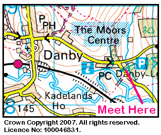
The second event is a day walk and will take place on Thursday, 5th August. It will start at 10.30 am from Danby Moors Centre {NZ 716 084} - see the map below.
The length of this walk will be up to 10 miles. Please telephone 01642-299312 for more details.
The third event is a ceilidh and will take place on Saturday, 7th August. It will start at 6.00 pm at Preston Park Walled Garden - see the map below.
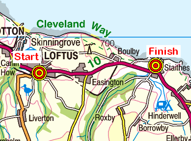
On Sunday, 1st August, the Stockton Rambling Club will have three walks in the eastern coastal area of the North York Moors. All walks will start in Loftus {NZ 721 181} and will finish in Staithes {NZ 781 185} - see the following map.
Crown Copyright (2010). All rights reserved. Licence No. 100046831. Produced using Anquet Maps.
The A-walk will take in Handale, Danby Beacon, Newton Mulgrave and Hinderwell.
The B-walk will visit Handale, Dodder Carr, Stang Howe and Hinderwell.
The C-walk will pass through Handale, The Warren, Park House, Roxby and Hinderwell.
This is a Route 1 coach pick up (Billingham: 9.30 am, Stockton: 9.45 am and Acklam: 10.00 am).
Our three expeditions this week (Sunday, 18th July) each took place in the Stainton Dale area of North York Moors. The A-Walk and the B-Walk each set off from different points on the A684 road just south of The Flask Inn; the C-Walk commenced further down the A684 road at The Falcon Inn. All three walks finished at Ravenscar.
After leaving The Falcon Inn {SE 971 980}, the intent of the C-Walk was to visit Tofta Hill, Staintondale, the Hayburn Wyke Inn, Sycarham Farm and Hayburn Wake before arriving at our final destination in Ravenscar {NZ 981 016}.
We left our drop-off point at about 11.10 am. There were nineteen people in the group. PB led the walk.
We set off from the Falcon Inn (see the picture above) and walked in an easterly direction along the loop road towards the road junction at {SE 973 980}. Turning left into Rudda Road, we followed this in a northerly direction towards Thorny Beck. Just after the stream, we turned right at {SE 973 984} and followed a public footpath across the fields in an east-south-easterly direction towards Island Farm {SE 981 980}.
After passing by the farm, we made our way along the farm access track to Brown Rigg Road. We now followed this in a south-easterly direction to its junction with Prior Wath Road {SE 985 981} where we turned left. With Tofta Hill on our left, we now followed the road into the small village of Staintondale {SE 990 984}
From the village, we navigated a route to Bees Nest Farm where we joined the route of the (now disused) Whitby/Scarborough railway line {SE 993 985}. We followed this in a south-easterly direction to the site of Staintondale Station {SE 999 978} - which has now been converted into a private dwelling (see the picture below).
Continuing our south-easterly trek along the disused railway track, we eventually reached The Hayburn Wyke Inn {TA 007 968} (see the picture below) where we stopped for a restful lunch stop.
After our lunch break we continued along the old railway track in a south-easterly direction through Newton Dale until we reached the stone bridge at {TA 015 955}. At this point we left the course of the railway and descended to the road that passed beneath the bridge. We followed the road in an easterly direction to Sycarham Farm {TA 017 955}. At the farm we took a good track on our left and followed this in order to reach the Cleveland Way (CW) long-distance footpath at {TA 017 960} near Roger Trod.
As we went north on the CW, we had some spectacular views of the North Sea and the coastline. When we reached the nature reserve at Hayburn Wyke {TA 009 970} we had a steep descent down to the wooden bridge that crossed Hayburn Beck (see here). Our descent was then followed by an equally steep ascent back up to the cliff-top near Red House Farm {TA 009 974}. Fortunately, our ascent was facilitated by a well-constructed wooden 'staircase' (see here).
We rested for a short period at the top of the wooden steps and then continued our northerly coastal trek towards Herbert Hole {TA 009 978} and onwards to Petard Point {TA 004 987} where we stopped for a short tea stop.
After our very pleasant and restful tea break, we continued on our trek along the CW towards Beast Cliff {SE 997 996}. As we progressed along the coastline we passed by the (now disused) coastguards' lookout station near Common Cliff {NZ 992 008} - see the picture below.
As we approached the southern end of Ravenscar, we passed by a very tempting tea-room on our left (see here). Despite its 'attractiveness', we held our focus and continued along the CW towards Raven Hall. Turning left at {NZ 98212 01880} we made our way to the junction of the CW with Station Road in Ravenscar where our coach was waiting to transport us back to Teesside.
Prior to our departure, some of us made our way back to the tea-room that we had previously passed while others ventured into Raven Hall (see here) for refreshments.
Use the buttons below to see where we went, how we did and some of the photos.
During the week beginning 26th July, Stockton Rambling Club will have TWO mid-week walks available. One is an evening walk and the other is a day walk.
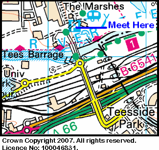
The evening walk is on Wednesday, 28th July and will start at 7.00 pm from The Talpore near the Tees Barrage - see the map below.
This walk will be not be longer than 6 miles. Please ring 01642-880261 for more details.
The day walk is on Thursday, 29th July. It will start at 10.30 am from the far end of the car park at the George Hotel in Piercebridge {NZ 212 155} - see the map below.
Crown Copyright (2009). All rights reserved. Licence No. 100046831. Produced using Anquet Maps.
The length of this walk will be up to 10 miles. Please telephone 01642-654861 for more details.
On Sunday, 25th July, the Stockton Rambling Club will have four walks in the North-Western area of The Lake District. All walks will finish in Keswick {NY 265 235} - see the following map.
Crown Copyright (2010). All rights reserved. Licence No. 100046831. Produced using Anquet Maps.
The A-walk will start at Seatoller {NY 244 137} and will take in Dale Head, Hindscarth and Cat Bells. This walk will involve 3400 feet of ascent.
The B-walk will also commence at Seatoller and will visit High Spy, Maiden Moor and Cat Bells. This walk will involve 2200 feet of ascent.
The C-walk will set off from Rosthwaite {NY 258 149} and will follow part of the Cumbria Way and then pass through Catbells Terrace. This walk will involve 1000 feet of ascent.
The D-walk will set off from Grange {NY 252 174} and will follow part of the Cumbria Way to Portinscale before returning to Keswick. This walk will involve 350 feet of ascent.
This is a Route 2 coach pick up and is also an early start (Billingham: 8.30 am, Acklam: 8.45 am and Stockton: 9.00 am).
Our three expeditions this week (Sunday, 11th July) each took place in the Wensleydale area of North Yorkshire. The A-Walk set off from Hawes, the B-Walk started at Aysgarth Falls and the C-Walk commenced at {SD 995 888} on the A684 road - just west of Aysgarth. All three walks finished at Hawes.
After leaving Hawes {SD 875 898}, the intent of the A-Walk was to visit Hardraw, Great Shunner Fell, Cotterdale, High Dyke and Appersett before arriving at our final destination back in Hawes.
We left our drop-off point at about 11.40 am. There were eight people in the group: JB, JPB, PB, KF, CH, AM, LM and JT. We welcomed a new member (JT) to our group. JB led the walk.
From the car park near the old railway station in Hawes we followed the Pennine Way (PW) (see the picture below) in a northerly direction to reach Haylands Bridge {SD 876 904}.
We used the bridge to cross the River Ure and continued along Brunt Acres Road until we reached {SD 877 905}. We then turned left and crossed the fields in a north-westerly direction to reach Hardraw {SD 867 912}. After crossing Hardraw Beck, we turned right and followed the PW uphill to Hollin Hill {SD 865 916}. Now turning onto a north-westerly bearing, we had a good climb up over Bluebell Hill {SD 860 918}. to reach the junction of the PW with Hearne Coal Road {SD 857 921}.
Staying on the PW, we continued climbing to reach a rock outcrop near Hearne Top {SD 847 931}. We decided to stop here for lunch - in order to take advantage of the rocks to shelter from the wind and rain that had now set in. The weather conditions had changed considerably since leaving home!
After our short lunch break, we continued climbing along the route of the PW in order to reach Black Hill Moss {SD 842 945}. As we went north we saw extensive evidence of mining and encountered numerous peat bogs of the type shown below.
Continuing our northerly trek, we climbed up to Crag End Beacon {SD 843 955} and maintained our bearing of 6° until we reached Hearne Head {SD 844 966}. We now had our final climb up onto the summit of Great Shunner Fell {SD 848 972} - our first highlight of the day!
We searched around for evidence of the trig point on the top - but could not find it - even though the wind shelter was clearly visible (see the above picture).
From the summit we back-tracked along the PW in a southerly direction until we reached Crag End Beacon (again!). We now turned right onto a westerly bearing and descended over the rough moorland that made up East Side in order to reach an old mining track at {SD 837 954} near a disused pit.
Turning left, we followed this track to its junction with a second track at {SD 836 948}. We now turned right and followed this more well-defined track downhill. After some zig-zagging through East Side Wood we eventually reached the footbridge over East Gill {SD 832 943} where we stopped for a short tea break.
From our tea-stop location, we headed south to the small village of Cotterdale {SD 832 938}. We now followed the public footpath in a west-north-westerly direction and crossed West Gill using the stepping stones at {SD 827 940}.
Once we had crossed the stream, we started the second major climb of the day. This took us on a westerly bearing through the woods towards Dry Gill Head {SD 816 942} and onwards to Johnston Gill {SD 810 943} which we crossed with the aid of a footbridge and stepping stones. From here we made a gradual descent to High Dyke {SD 802 942}. This was the second highlight of the day! There were some magnificant views of Wild Boar Fell, Swarth Fell and East Baugh Fell from here.
Now turning onto a south-westerly bearing we followed the route of the public footpath along The High Way until we reached Cotter Clints {SD 822 930}. Just after this we started our descent towards Cotter Riggs {SD 837 923} and joined the A684 road at {SD 842 920}. We followed the road to the small village of Appersett {SD 858 907}.
After crossing Widdale Beck using the road bridge (see the above picture), we continued along the road to its junction with the B6255 road at {SD 868 898} near Pike Hill. Staying with the A684 road, we walked in an easterly direction through Hawes to reach the car park from where we had started and in which our coach was now waiting to take us back to Teesside.
Many thanks to JB for organising such an interesting and exciting adventure for us today. Despite the road walking at the end, we had a really great time. Use the buttons below to see where we went, how we did and some of the photos.
During the week beginning 19th July, Stockton Rambling Club will have TWO mid-week walks available. One is a day walk and the other is an evening walk.
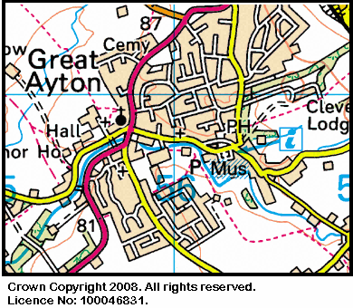
The day walk is on Wednesday, 21st July and will start at 10.30 am from the Royal Oak in Great Ayton - see the map below.
This walk will be not be longer than 5 miles. Please ring 01642-780538 for more details.
The evening walk is also on Wednesday, 21st June. It will start at 7.00 pm from the Royal Oak - see the picture below.
The length of this walk will be up to 6 miles. Please telephone 01642-764006 for more details.
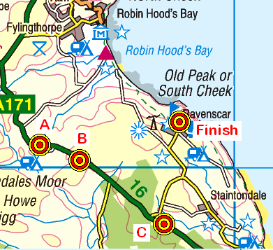
On Sunday, 18th July, the Stockton Rambling Club will have three walks in the South-Eastern area of the North York Moors. All walks will finish in Ravenscar {NZ 980 016} - see the following map.
Crown Copyright (2010). All rights reserved. Licence No. 100046831. Produced using Anquet Maps.
The A-walk will start at the Flask Inn {NZ930 008} and will take in Stoupe Brow, Sycarham Farm and a section of the Cleveland Way.
The B-walk will commence at Jugger Howe {NZ 944 002} and will visit Stony Marl Moor, Sycarham Farm and a section of the Cleveland Way.
The C-walk will set off from near the Falcon Inn {NZ 973 980} and will pass through Bees' Nest Farm, Sycarham Farm and a section of the Cleveland Way.
This is a Route 1 coach pick up (Billingham: 9.30 am, Stockton: 9.45 am and Acklam: 10.00 am).
During the week beginning 12th July, Stockton Rambling Club will have TWO mid-week walks available. One is an evening walk and the other is a day walk.
The evening walk is on Wednesday, 14th July and will start at 7.00 pm from the Lord Stones Cafe near Carlton {NZ 524 030} - see the map below.
This walk will be not be longer than 6 miles. Please ring 01642-648682 for more details.
The day walk is on Thursday, 15th July. It will start at 10.30 am from Eggleston Hall Garden {NY 998 234} (see the map below) and will involve a guided tour of the gardens followed by an optional post-tour walk. The cost of the tour is £2.00. Further details about the venue can be found here.
Crown Copyright (2009). All rights reserved. Licence No. 100046831. Produced using Anquet Maps.
The length of the post-tourwalk will be up to 6 miles. Please telephone 01740-644347 for more details.
On Sunday, 11th July, the Stockton Rambling Club will have three walks in the Wensleydale area of North Yorkshire. All walks will finish in Hawes {SD 874 898} - see the following map.
Crown Copyright (2010). All rights reserved. Licence No. 100046831. Produced using Anquet Maps.
The A-walk will start at Hawes and will take in Great Shunner Fell, Cotterdale and The High Way.
The B-walk will commence at Aysgarth Falls {SE 011 887} and will visit Newbiggin, Helm, Sedbusk and Hardraw
The C-walk will set off from Aysgarth {SE 011 883} and will pass through Nappa Mill, Askrigg, Skell Gill and Sedbusk.
This is a Route 2 coach pick up (Billingham: 9.30 am, Acklam: 9.45 am and Stockton: 10.00 am).
Our three expeditions this week (Sunday, 27th June) each took place in the Cumbria/Northumberland area surrounding the River South Tyne. The A-Walk set off from Alston, the B-Walk started at Castle Nook and the C-Walk commenced at Slaggyford. All three walks finished at Haltwhistle.
After leaving Alston, the intent of the A-Walk was to visit Harbut Lodge, Castle Nook, Slaggyford, Burnstones, Low Burnfoot and Wydon Eals before arriving at our final destination in Haltwhistle.
We left our drop-off point at about 11.50 am. There were seven people in the group: JB, PB, RB, MC, KF, CL and LM. PB led the walk.
From the centre of Alston {NY 717 463} we followed the A689 road in a southerly direction to reach the road bridge over the River South Tyne. We crossed the river in order to reach the war memorial and then followed the route of the Pennine way (PW) in a north-north-easterly direction towards Harbut Lodge {NY 711 473}. As we went north we had some good views of Alston on the opposite side of the river. After crossing the A689 road at {NY 695 490} we made our way in a north easterly direction towards Gilderdale Beck which we crossed using the footbridge at {NY 698 478} - see the picture below.
We continued on our north-easterly bearing and then 'circled around' the site of the Roman Hill Fort at Whitley Castle. From here, we dropped back down to the A689 road at Castle Nook {NY 695 490}. After crossing the road, we continued along the PW - passing Dyke House {NY 695 493} on our left. Just to the right of our route we could see the South Tynedale Railway and one of the steam trains waiting at Kirkhaugh Station. Just after passing through Kirkhaugh, we decided to stop for a short lunch break at {NY 692 501}.
From our lunch stop location we continued on our north-westerly trek to Lintley {NY 687 511} where we left the PW. From near the road bridge at {NY 684 512}, we now followed the South Tyne Trail along the course of the dismantled railway in order to reach the old (now disused) railway station at Slaggyford {NY 676 523}. We stayed on the railway track until we reached {NY 672 530}. At this point we turned onto a bearing of 333° and made our way to the farm at Merry Knowe {NY 670 534}. At this point we became 're-united' with the PW and followed this to the bridge and viaduct at Burnstones {NY 675 543} where we crossed Thinhope Burn using the road bridge (see the picture below).
Staying on the PW we now trekked in a northerly direction to reach the footbridge over Glendue Burn at {NY 670 563}. After crossing the stream we stopped for a short tea break. Following our short rest, we continued on our northerly trek over the moorland terrain that makes up Lambley Common. We then crossed the A689 road at {NY 663 586} and continued in a northerly direction until we reached High House {NY 660 598}.
We now turned onto a north-easterly bearing and crossed Hartley Burn using the footbridge at {NY 662 601}. Keeping our north-easterly bearing, we continued onwards to reach the footbridge at Low Burnfoot {NY 669 608}. We now followed a good footpath through the woods along the west side of the River South Tyne to reach Featherstone Bridge {NY 675 619}.
Maintaining our north-easterly trek, we moved on to Wydon Eals {NY 681 623}. From here we walked across the fields to Wydon {NY 690 631} - where the farmers were busily making hay while the sun was shining.
From Wydon we now just had a short walk to reach the railway station in Haltwhistle {NY 704 638} where our coach was waiting to take us back to Teesside.
Even though the coach numbers were down, we had an interesting and exciting adventure today. We had a really great time - many thanks to PJ and RB.
Use the buttons below to see where we went, how we did and some of the photographs.


")

