On Sunday, 6th December, the Stockton Rambling Club will have three walks in the Western Region of the North York Moors. All walks will finish in Slapewath {NZ 642 158} - see the following map.
Crown Copyright (2009). All rights reserved. Licence No. 100046831. Produced using Anquet Maps.
The A-walk will start at Stokesley {NZ 525 086} and will take in Great Ayton, Captain Cook's Monument and Sleddale.
The B-walk will also commence at Stokesley and will visit Great Ayton, Roseberry Common and Sleddale.
The C-walk will set off from Great Ayton {NZ 562 106} and will pass through Newton Wood and Roseberry Common; it will then follow the Cleveland Way.
This is a Route 1 coach pick up and is also an early start (Billingham: 9.00 am, Stockton: 9.15 am and Acklam: 9.30 am).
Note: After the walks, there will be a meal in the Fox and Hounds in Slapewath. Booking is therefore essential for this event.
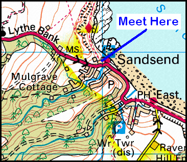
On Thursday, 3rd December, Stockton Rambling Club will have a mid-week walk in the Sandsend area of the North York Moors. Please meet at 10.30 am at the Lythe Bank Car Park in Sandsend {NZ 860 128} - see the following map.
Crown Copyright (2009). All rights reserved. Licence No. 100046831. Produced using Anquet Maps.
The walk will not be longer than 10 miles (C-pace). For further details ring 01325-469476.
After last weekend's wonderful walking spree on the North York Moors, our expedition today located us back in County Durham again - a circular route from Barnard Castle {NZ 050 166}. Our trek took us along the side of the River Tees to Cotherstone, south-west to Loups's Hill and then east back to Barnard Castle via Deepdale.
We set off from Morrison's car park in Barnard Castle {NZ 051 166} (see picture below) at about 10.15 am. There were 9 people in the group: JB, PB, RB, MC, KF, JG, CH, JJ and LM. PB led the walk.
From the church at the end of Galgate (see here), we set off in a north-westerly direction along the route of the Teesdale Way (TW). Our route followed the course of the River Tees (along its east side) fairly closely. We passed by East Holme House {NZ 029 189} (see here) and West Holme House {NZ 027 191} (see here). As we headed north, we had some very good views of the River Tees.
We crossed the river by means of a footbridge near the confluence of the River Tees and the River Balder {NZ 013 202}. At this point we left the TW by turning west towards Cotherstone. After crossing the River Balder using the bridge at {NZ 013 201}, we climbed up into the village. We entered Cotherstone at {NZ 011 198) near the village green (see here). Walking through the village in a north-westerly direction, we crossed the River Balder (again) using the road bridge at {NZ 009 200} (see here).
Just after the bridge we picked up a westerly-going public footpath (on our left) that took us towards Doe Park {NZ 005 201}. We continued on our westerly bearing (crossing the dis-used railway track at {NY 995 203}) until we reached the track leading to West End. We now turned onto a southerly bearing and made our way to a footbridge at {NY 992 200}. We used this to cross the River Balder (our third crossing!). Continuing on our southerly bearing we reached a minor road at {NY 991 197} near Osmond Bridge. We turned right here and followed the road to {NY 990 197} where we turned left onto the track leading to High Corn Park. Now following the route of Osmond Beck we made our way to Booze Wood where we stopped for a quick lunch break - taking shelter from the strong winds behind some farm buildings at {NY 986 190}.
After lunch, we joined a minor road at {NY 985 189}. Turning right along it, we followed the road in the direction of Briscoe. We left the road at {NY 978 193} and made a south-westerly trek over the open moorland towards Loups's Hill {NY 964 175}. This gave us the opportunity to enjoy a long, uphill 'pull' against a very strong head-wind. As we turned east and made our way along the ridge to the high ground (see picture below), we had some wonderful panoramic views of the surrounding terrain. The view north to Hury Reservoir was particularly spectacular (see here).
We continued along the ridge to East Loups's (a deserted farm house) and then followed a good track along the route of Scur Beck. At {NY 996 175} we joined a minor road at North Gill Bridge. At this point, one or two people who had got significantly ahead of the leader went the wrong way. We had to do a 'whistle blow' in order to attract their attention and 'bring them back'.
After re-grouping at the bridge, we followed the road in a southerly direction towards Washfield Bridge {NY 996 170}. As we went along the road we passed the Ministry of Defence's Battle Hill Rifle Range on our right. We continued along the road until we reached {NY 993 162} where we took a public footpath on our left. This led us in an easterly direction to the crags at Crag Hill {NY 996 162} - see the picture below.
We passed through the farm at Low Crag and made our way down-hill towards Crag Pond - passing this on our left. Just after the pond (more like a lake!) we took refuge behind a wall and had a short tea stop at {NZ 005 162}.
After our brief stop, we continued on our easterly trek into Deepdale Wood. Keeping the river (Deepdale Beck) on our right (and below us) we continued along - an often very muddy - track through the wood until we reached the B6277 road. We had intended crossing the River Tees here using Deepdale Aquaduct. Unfortunately, due to restoration work on the bridge, this was not possible. Instead, we used the A67 road bridge at {NZ 048 164}. From here we followed a good path up-hill around the west side of the castle to reach the church at Galgate. It was now just a short walk back to Morrison's car park where our coach was waiting.
We had a wonderful expedition today - lots of mud, wind and excitement! Some of the views we saw were really quite spectacular. Use the buttons below to see where we went, how we did and some of the sights we saw.
On Sunday, 29th November, the Stockton Rambling Club will have three walks in the Castleton area of the North York Moors. All walks will finish in Lealholm {NZ 763 076} - see the following map.
Crown Copyright (2009). All rights reserved. Licence No. 100046831. Produced using Anquet Maps.
The A-walk will start at Brown Hill {NZ 670 116} and will take in Castleton, Danby Rigg and Danby Lodge.
The B-walk will commence at Castleton {NZ 685 080} and will visit Bolton Farm, Danby Rigg and Danby Lodge.
The C-walk will set off from Brown Hill and will pass through Castleton, Danby Low Moor and Danby Lodge.
This is a Route 1 coach pick up and is also an early start (Billingham: 9.00 am, Stockton: 9.15 am and Acklam: 9.30 am).
On Thursday, 26th November, Stockton Rambling Club have a mid-week walk in the Guisborough area of the North York Moors. Please meet at 10.30 am at Guisborough Rugby Club {NZ 616 154} - see the following map.
The walk will not be longer than 10 miles. For further details ring 01642-656273.
Following last week's successful expeditions in County Durham, our activities this week took us to the south-western region of the North York Moors. Our route today took us from the Visitors' Centre at Sutton Bank {SE 516 830} (see picture below) to Kepwick via Cold Kirby, Old Byland, Tylas Farm, Coomb Hill, Hawnby and Arden Hall.
We set off from our drop-off point at the Visitors' Centre at about 10.15 am. There were 6 people in the group: JB, PB, RB, KF, CH and LM. PB led the walk.
We left the Sutton Bank Visitors' Centre in an easterly direction along the A170 road. At the Hambleton Inn {SE 524 830} we turned left along a good track towards Hambleton House {SE 524 834}. Just before the house we turned right onto the Cleveland Way (CW) long-distance footpath. We now followed the route of the CW in an easterly direction to {SE 528 835}. At this point we turned left onto a northerly bearing across fields to reach {SE 527 840}. Swinging to the right, we followed Cote Moor Road (a track) into the small village of Cold Kirby {SE 531 845}.
From the centre of the village, we circled around the back of the church to reach a track (Low Field Lane) at {SE 535 844}. Turning left along this lane, we followed it in an easterly direction and then descended into the woods leading into Flassen Dale {SE 535 844}. We paused for a group photograph at {SE 549 846}.
Continuing along the CW in an easterly direction, we came to a style and footbridge on our left {SE 556 846} - at the west end of Nettle Dale. We left the CW here and had a very pleasant climb in a north-westerly direction through Callister Wood to reach the open fields at {SE 553 849}. We now headed north across the fields in the direction of Old Byland {SE 550 859}.
After passing through the village, we took a public footpath at {SE 552 860} and followed this on a northerly bearing to find a 'finger-post' in the corner of a field at {SE 551 864}. At this point, we turned right in order to make an easterly trek to Tylas Barn {SE 561 866}. We had some very good views of Rievaulx Abbey (see here) from our vantage point on the high ground.
From Tylas Barn we descended to Tylas Farm where we turned onto a northerly bearing. Our route now took us to Barnclose Farm {SE 566 871}. Just after the farm we turned into north-westerly bearing in order to follow a public footpath that took us along the western side of Rye Dale. Because of the wonderful views that we had from here, we decided to take a short lunch break just at the edge of Hag Wood {SE 562 875}.
As we left our lunch spot, we had some very picturesque views of Easterside Hill (see here) as we made our way north towards Shaken Bridge Farm {SE 558 882}. Just before the farm we dropped down to the minor road at {SE 559 883}. As we made our descent, there were some very good views of Shaken Bridge and the River Rye. Turning left along the minor road, we followed this in a north-westerly direction to find a footpath (on our right at {SE 550 888}) just before we reached Ristbrow Farm.
Taking this fotpath, we followed it to Hawnby Bridge (SE 543 893} where we crossed the River Rye. Turning left, we followed the minor road into and through the village of Hawnby {SE 542 894} - see the picture below.
Leaving the village of Hawnby, we stayed with the road - following it to Delicar Bridge and then Church Bridge {SE 535 899}. Just after the bridge we turned left along a footpath that took us in a westerly direction pass Carr Woods (on our left) and into Nag's Head Wood {SE 530 899}. While in the wood we 'followed the contours' in a clockwise quarter-circle around Coomb Hill. At {SE 523 902} we emerged from the wood and made our way to {SE 520 903}.
At this point, the public footpath did a mysterious 'about turn' and took us in a north-easterly direction to a very muddy track. This led us down down an extremely steep hill to the minor road at {SE 523 904}. Following this in a westerly direction, we made our way to the entrance of Arden Hall. We took a northerly path through the grounds - stopping for a short tea break at {SE 518 907}.
After our tea break we climbed up to {SE 519 909} where we turned left along a good forest track through North Moor Wood. This led us in a westerly direction along the northern side of Thorodale. As we went through the woods we had some very good climbs. Emerging from the wood at {SE 502 916}, we made our way downhill to the beck at {SE 500 916}. We followed the course of this to {SE 497 917} where we commenced our final major ascent of the day - up to {SE 495 919}. This was a really steep one - but the views back down through Thorodale were really fantastic.
As soon as our climb was over, we made our way in a westerly direction to {SE 490 919} where we crossed the Cleveland Way. Continuing on our westerly trek, we started to make our ascent from the high ground. As we made our way downhill, we could see the B-Party ahead of us - their number counting to 36 in total. We continued in 'hot persuit' of our colleagues and by the time we reached Nab Farm {SE 476 921} we had passed them. However, SR decided to stay with us as we pushed on downhill to reach the minor road at {SE 469 918}. At this point I decided to introduce a minor 'amendment to route' (see here).
Instead of following some field paths that lay a little further to the west, I decided to proceed to Kepwick (our final destination) using the minor road that entered the village at {SE 470 910}. This gave us a slightly shorter route than the one that was originally planned - but I thought it would be less muddy. As a result of taking the road, we were able to finish the walk with a nice little climb from {SE 470 910} up to {SE 470 910}. As we arrived in the village, our coach was waiting for us just near to the entrance to Kepwick Hall (see the picture below).
Well, what a great expedition we had today! We had no rain, lots of good climbs, a steady pace and, to crown it all, lots of mud. What walker could wish for more? We had a really great time - at least until our coach broke down in Stockton!
Use the buttons below to see where we went, how we did and some of the sights we saw.
On Sunday, 22nd November, the Stockton Rambling Club will have three circular walks in the Cotherstone area of County Durham. All walks will start and finish in Barnard Castle {NZ 049 166} - see the following map.
Crown Copyright (2009). All rights reserved. Licence No. 100046831. Produced using Anquet Maps.
The A-walk will take in Cotherstone, Booze Wood, Loups' Hill, Crag Hill and Deepdale.
The B-walk will visit Cotherstone, Cuckoo and Crag Hill.
The C-walk will pass through Naby,Cotherstone and West Holme.
This is a Route 2 coach pick up and is also an early start (Billingham: 9.00 am, Acklam: 9.15 am and Stockton: 9.30 am).
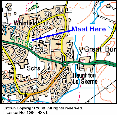
On Wednesday, 18th November, Stockton Rambling Club have a mid-week walk in the Darlington area of County Durham. Please meet at 10.30 am at Asda {NZ 309 168} in Whinbush Way - see the following map.
The walk will not be longer than 5 miles. For further details ring 01325-266803.
The small village of Rushyford {NZ 282 288} in County Durham is located near the two round-abouts that make up the intersection of the westerly going A689 road and the north-bound A167 road. We often pass by the village en route for Weardale. Today's expedition took us from the Rushyford area to Shincliffe via Ferryhill, Hett, Tudhoe, Sunderland Bridge and Croxdale Hall.
We set off from our drop-off point on the A689 road {NZ 295 286} (see the picture below) at about 10.00 am. There were 9 people in the group: JB, PB, RB, MC, KF, CH, JH, LM and WM. WM led the walk.
After negotiating the gate, we followed a northerly bearing along a good track that took us through Standalone to the south-eastern corner of the village of Chilton {NZ 293 294}. From here we made an easterly trek to Kay's Hill where we turned back onto a northerly bearing in order to reach Great Chilton Farm {NZ 298 302}.
After crossing the minor road at {NZ 298 305} we continued on our northerly bearing over Wheel Hill {NZ 297 306} and onwards to reach Ferryhill. We entered the village at {NZ 290 322} and made our way through a network of roads and houses to emerge in open land again at {NZ 292 331}.
We continuerd on our northerly trek - crossing a dismantled railway at {NZ 287 337}. Our path now took us pass a large electricity sub-station (on our right) as we joined the A688 road (Thinford Lane) at {NZ 285 346}. We walked in a westerly direction for about 200 yards and then turned right onto a footpath at {NZ 283 346} that took us in a northerly direction to a minor road at {NZ 281 356}. Turning right, we followed this into the small village of Hett {NZ 281 364} - see the picture below.
Turning left pass the village hall, we headed in a westerly direction to cross the A167(T) road at {NZ 274 362}. Our route now took us across the fields to a school on the outskirts of Tudhoe Colliery {NZ 266 359}. Continuing on a south-westerly bearing we arrived at Tudhoe Village {NZ 258 356} where we had a short lunch stop on the village green.
After lunch, we headed in a south-westerly direction to cross Valley Burn. We then had a very pleasant westerley trek through Spring Wood to reach the River Wear at {NZ 242 359}. As a consequence of yesterday's heavy rainfall, the level of the river was very high - and it was flowing at a tremendous speed. Turning onto a north-easterly bearing, we now followed the course of the river to Sunderland Bridge {NZ 265 378} (see picture below) where we joined the route of the Weardale Way (WW). As we approached Sunderland Bridge we had some very good views of the Croxdale Railway Viaduct {NZ 263 376}.
After stopping for a while in order to watch the turbulent waters of the River Wear, we entered the Croxdale Estate and followed the WW along a good road to Croxdale Hall {NZ 274 378}. We stopped here (near the church) for a short tea break. Continuing along the WW, we now made our way to High Butterby Farm {NZ 288 389}
From the farm, we descended down a steep, muddy path into Shincliffe Wood and continued along the route of the WW until we reached the village of Shincliffe {NZ 289 409} - where our expedition ended.
Many thanks to WM for organising such an interesting and exciting adventure for us today. We had a really great time. Use the buttons below to see where we went, how we did and some of the sights we saw.
Note
JB and I had a really delicious cup of tea (or two or three) in The Rose Tree at the end of the walk.
On Sunday, 15th November, the Stockton Rambling Club will have three walks in the Sutton Bank area of the North York Moors. All walks will finish in Kepwick {SE 469 909} - see the following map.
Crown Copyright (2009). All rights reserved. Licence No. 100046831. Produced using Anquet Maps.
The A-walk will start at Sutton Bank {SE 516 830} and will take in Old Byland, Hawnby and Arden Hall.
The B-walk will also commence at Sutton Bank and will visit Tang Hall, Gurtof Wood and Gallow Hill.
The C-walk will set off from near Ox Bank{SE 431 926} and will pass through Nether Silton, Black Hill and Gallow Hill.
This is a Route 1 coach pick up and is also an early start (Billingham: 9.00 am, Stockton: 9.15 am and Acklam: 9.30 am).
On Thursday, 12th November, Stockton Rambling Club have a mid-week walk in the Bilsdale area of the North York Moors. Please meet at 10.30 am at Chop Gate car park {SE 559 993} - see the following map.
The walk will not be longer than 10 miles. For further details ring 01642-805781.
The Catterick area is probably most well known for horse racing and its close-by army barracks. However, for walkers and outdoor enthusiasts it is also a useful starting point for walks along the River Swale - and the access it provides into Swaledale. Today's expedition took us from Catterick Bridge to the town of Richmond via Brompton-on-Swale, Skeeby, Gilling West, Willance's Leap and East Applegarth.
We set off from our drop-off point (near the junction of the A6136 and B6271 roads) {SE 225 999} at about 10.14 am. There were 6 people in the group: PB, KF, CH, LM, JY and PY. PB led the walk.
Following the A6136 in a southerly direction we made our way to the road bridge over the River Swale (see picture below) where we turned right onto a footpath at {SE 227 994}. From here we headed in a westerly direction along the river bank. After passing under the old railway bridge (see here) and then under Agricola Bridge (see here),we skirted around the south-western edge of Brompton-on-Swale in order to reach the B6271 road at {SE 215 997}. Turning left, we walked along the road for about 490 yards in order to find a footpath on our right at Brompton Bridge {SE 212 999}. This path took us in a north-westerly direction to Union House {NZ 202 016} and then on to the village of Skeeby {NZ 198 025}.
We left Skeeby on a north-westerly path that took us to Gascoigne Farm {NZ 196 033}. Staying on our north-westerly bearing, we went along the western side of Gilling Beck in order to reach the small village of Gilling West {NZ 183 052}. As the weather conditions were so bad, we had our lunch stop here - in a bus-shelter near the church {NZ 182 051}. Just as we were finishing our lunch, the B-group arrived so we hastily vacated our shelter so that they could make use of it.
From the church we made a south-westerly trek across the fields and along Old Hall Lane to {NZ 174 045}. Now changing to a north-westerly bearing we passed through The Ashes and then entered Gilling Wood at {NZ 160 050} on a south-westerly bearing. We had a good climb through the wood along a well-defined track. While we were in the wood, the trees provided some good cover - both from the wind and the rain.
We emerged from Gilling Wood onto a minor road at {NE 155 046} and turned left along it. After about 65 yards we turned right onto a south-westerly going path along the northern edge of Black Plantation. Maintaining our south-westerly bearing, we arrived at a path junction at {NZ 141 034}. At this point we entered a wood (Beacon Plantation) on Richmond Out Moor. We made a southerly trek through the wood so as to reach a minor road near the aerial masts at {NZ 139 024} (see here). From here we went across the fields to reach the monument at Willance's Leap {NZ 136 021} - see the picture below. We had some good views of the River Swale and the surrounding landscape from here.
Leaving the monument on a westerly bearing, we followed the high ground around to {NZ 129 024}. We were exposed to some very strong winds during this section of the walk - so much so, it was, on occasions, difficult to maintain an upright position. When we reached the road (see here), we swung onto a southerly bearing and descended into the valley in the direction of Low Applegarth. At {NZ 129 017} we turned left onto a path that took us in an easterly direction to East Applegarth (see here) and Whitecliffe Wood. While in the wood, we decided to take advantage of the shelter it offered and had a short tea stop at {NZ 144 015}.
We emerged from the wood at {NZ 146 014} and made our way to High Leases and Whitcliffe Farm. There were some good views of Richmond Castle (see the picture below) as we made our way along the lane. Just after the farm, at {NZ 154 015}, we turned right into Green Lane and descended to the A6108 road at {NZ 155 008}. From here we made our way through the caravan park and re-joined the A6108 road at {NZ 161 011}. We followed this in an easterly direction into the centre of Richmond where our expedition ended in the car park at {NZ 168 011}.
When we set off today the weather conditions were pretty bad - and the numbers on the coach reflected this. We were exposed to very strong winds and incessant heavy rain. However, by late afternoon (as we approached Willance's Leap) the rain stopped, the sun appeared and we had some lovely light-blue sky. Nevertheless, despite these improvements in the weather, the strong winds stayed with us for the rest of the walk. Even though the conditions were not what we might have chosen, we had a really great day.
Use the buttons below to see where we went, how we did and a few of the sights that we saw.
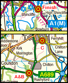
On Sunday, 8th November, the Stockton Rambling Club will have three walks in the Tudhoe area of County Durham. All walks will finish in Shincliffe {NZ 290 408} - see the following map.
Crown Copyright (2009). All rights reserved. Licence No. 100046831. Produced using Anquet Maps.
The A-walk will start at Rushyford {NZ 282 288} and will take in Tudhoe and Croxdale Hall.
The B-walk will also commence at Rushyford and will visit Hett, Tudhoe and Nickynack Bridge.
The C-walk will set off from Ferryhill {NZ 291 325} and will pass through Hett, Tudhoe, Nickynack Bridge and Croxdale Hall.
This is a Route 3 coach pick up and is also an early start (Acklam: 9.00 am, Stockton: 9.15 am and Billingham: 9.30 am).