Sunday Walking: Three Circular Walks from Rosedale Abbey
On Sunday, 5th July, the Stockton Rambling Club will have three walks in the Rosedale area of the North York Moors. All walks will start and finish at Rosedale Abbey {SE 723 960} - see the following map.
Crown Copyright (2009). All rights reserved. Licence No. 100046831. Produced using Anquet Maps.
The A-walk will take in Rock House, Leaf Howe, Cropton and Lastingham.
The B-walk will visit Hartoft Rigg, Cropton and Lastingham.
The C-walk will pass through Hollins Farm, High Askew, Lastingham and Ana Cross.
This is a Route 1 coach pick up (Billingham: 9.30 am, Stockton: 9.45 am and Acklam: 10.00 am).
One of SRC's long-standing members, Martin Spires (see the picture below) has recently completed yet another successful attempt at the Coast-to-Coast (C2C) long-distance walk.
Martin set off on his adventure on the 29th May and took 12 days to complete this (his fifth) C2C traversal. Well done Martin!
People who complete the walk are eligible for a C2C badge similar to that shown in the picture below. The yellow line in this badge depicts (roughly) the route of the C2C from St Bees (on the West Coast) {NX 962 116} through Kirkby Stephen {NY 775 085} to Robin Hoods Bay (on the East Coast) {NZ 953 049} - a distance of about 190 miles.
During his 12-day expedition, Martin kept a detailed record of his experiences and also took lots of photographs. Use the buttons below to see his weblog and a selection of his photographs.
As well as being a walker, Martin is also a keen cyclist. Later this year he hopes to complete a 'double traversal' of the C2C - on his bike.
Click here or here for further details on the Coast-to-Coast walk. Enjoy!
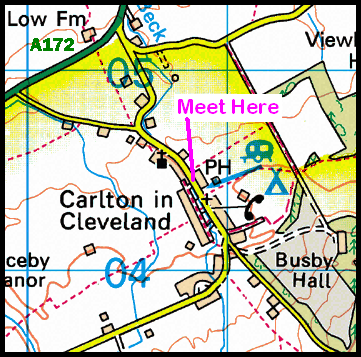
On Wednesday, 1st July, Stockton Rambling Club have a mid-week evening walk in the Carlton area of the North York Moors. Please meet at 7.00 pm at the Blackwell Ox {NZ 507 044} - see the following map.
Crown Copyright (2009). All rights reserved. Licence No. 100046831. Produced using Anquet Maps.
The walk will not be longer than 6 miles. For further details ring 07892-908201.
While 'everyone' was enjoying the SRC Lakes day, I did a little something closer to home! No rucksack, no compass, no GPS, no map, no water and no boots! I did this one in sandals1 - much to my regret (when I got wet feet). I didn't even take my camera - other than the one that resides inside my mobile phone.
So, on Sunday, 21st June (the Summer Solstice) I took my two daughters (Hannah and Steph) over to Clay Bank car park where we left the car. From there we walked up the approach track to Hasty Bank Farm (see the picture below2) and then onwards to Garfitts and the Wain Stones.
From the Wain Stones, we followed the Cleveland Way in an easterly direction to White Hill. Because the weather was so good we had some tremendous views. We sat for a while on the warm rocks and watched the world go by. The cars below (on the B1257 road) looked like ants 'busying' their way to where-ever they were going. We could not hear their noise; the silence was sheer bliss.
From White Hill we made the steep descent back to Clay Bank car park and drove home for tea - which, of course, was cooked by Dad!
What a great afternoon we had; only 3 miles and about 800 feet of ascent. However, it was sufficient to relax the mind, spirit and body after a hard week 'on the road' (Hatfield, London, Swansea and then home to Middlesbrough).
_____ Notes: 1 walking in my sandals was not an intentional activity and it was not done through choice! I just forgot to put my walking boots into the car. 2 as I did not have my camera with me, this photograph was taken on my mobile phone.
On Sunday, 28th June, the Stockton Rambling Club will have three walks in the Teesdale/Cumbria area. All walks will finish in Dufton {NY 689 250} - see the following map.
The A-walk will start at Bowlees {NY 906 281} and will follow the Pennine Way to High Cup Nick and Dufton.
The B-walk will commence at Langdon Beck Youth Hostel {NY 860 304} and will visit Widdy Bank Farm, Cauldron Snout, Maizebeck Scar and High Cup Nick.
The C-walk will set off from the car park at Cow Green Reservoir {NY 811 309} and will go to Cauldron Snout; it will then follow the Pennine way to High Cup Nick and Dufton.
This is a Route 2 coach pick up (Billingham: 9.30 am, Acklam: 9.45 am and Stockton: 10.00 am).
Quite recently, two of our SRC members, Paul and Julie Yellow (pictured below) successfully completed the Three Peaks of Yorkshire long-distance walk.
Involving a total climb of over 7,000 feet, it took our 'duo' 9 hours and 5 minutes to do the 24-mile circuit from Horton in Ribblesdale - where they camped prior to and after doing the walk. They camped out on the nights of the 27th and 28th May. On the day of the walk they clocked out from Pen-y-ghent Cafe at 5.15 am and clocked back in at 2.20 pm. Their route took them to Pen-y-ghent (694 m), Whernside (736 m) and Ingleborough (723 m) - see the map below.
Crown Copyright (2009). All rights reserved. Licence No. 100046831. Produced using Anquet Maps.
Further details about the Three Peaks walk can be found by following this link.
People who complete the walk are invited to join the 'Three Peaks of Yorkshire Club'. On joining the club, individuals are awarded a membership card and are then allowed to purchase a cloth rucksack badge similar to that shown in the picture below.
When I asked him what I should call this weblog entry, Paul replied: "Slog, Bog and Fog".
Note: There is another 'Three Peaks' walk - the National Three Peaks Walk which involves climbing Scafell Pike, Snowdon and Ben Nevis in under 24 hours.
Mid-Week Walking with SRC: Great Ayton and Castleton
During the week beginning 22nd June, Stockton Rambling Club will have TWO mid-week walks available. One is an evening walk and the other is a day walk.
The evening walk is on Wednesday, 24th June and will start at 7.00 pm from The Royal Oak in Great Ayton {NZ 563 107} - see the map and picture below.
This walk will be not be longer than 6 miles. Please ring 01642-586643 for more details.
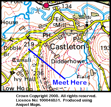
The day walk is on Thursday, 25th June. It will start at 10.30 am from the top car park in Castleton {NZ 680 077} - see the map below.
The length of this walk will be up to 10 miles. Please telephone 01642-778247 for more details.
Our expedition today (14-06-2009) took us into the heart of Swaledale. This week's trek took us from Reeth (see the picture below) to Booze, Washfold, Orgate, Marske and Applegarth to Richmond - our final destination.
We left the village green in Reeth {SE 038 993} at about 11.10 am. There were 9 people in the group: JB, PB, RB, KF, CH, JJ, WM, JY and PY. PB led the walk.
We set off in a northerly direction along the minor road from the centre of the village (see picture above). At {SE 349 000} we turned right, leaving the road, in order to take a footpath that led us in a north-westerly direction towards, and along, the western bank of Arkle Beck. We crossed the river using a footbridge at {NZ 010 021} and then 'backtracked' down the other side of the beck towards Storthwaite Hall. Just before the Hall, at {NZ 016 021}, we turned onto a northerly bearing in order to follow a path up along the west bank of Slei Gill. As we went north, we got some wonderful views of the waterfalls on our right. We had our lunch stop in Slei Gill.
After lunch, we held our northerly bearing until we reached Slack Wife Gill {NZ 022 036} and then we swung onto an easterly course1 in order to reach Moresdale Road. From here we followed a clockwise, semi-circular route (via Schoolmaster Pasture) in order to get to Washfold {NZ 055 027}. Now turning east, we chased the route of Padley Beck and then Shaw Beck so that we could get to Helwith Bridge {NZ 074 028} (where we should have2 crossed the beck using the footbridge!) and then continued on to Telfit Farm {NZ 086 026}. We had our short tea break just before the climb up to the farm.
After tea, following the route of Marske Beck on our left, we now made a south-easterly trek along a good farm track to arrive at the small village of Marske {NZ 105 006}.
Leaving Marske in an easterly (turning north-easterly) direction along the road, we found a footpath on our right at {NZ 109 009}. We followed this across the fields to Applegarth Scar {NZ 117 015} where we joined a good track that took us in an easterly direction to West Applegarth and then East Applegarth {NZ 134 017}. We stayed with this track, following it in an easterly direction through Whitecliffe Wood and onwards to Richmond where our expedition ended in the car park at {NZ 168 011}. As usual, our 'faithful' coach (and Duncan our driver) were awaiting our return.
Although the weather was a 'bit hot' for serious walking, we had a great day. We saw some terrific scenery and had some good climbs. Use the buttons below to see where we went and how we did.
Notes: 1 because the people at the front of the group were not sure of the route, we had to make a couple of minor 'amendments to route' in order to get back onto the planned route. These deviations added a little extra distance to the actual route as walked. Click this link to see the details.
2 because the people at the front of the group were not sure of the route, we had to make a major 'amendment to route' in order to get back onto the planned route. This deviation added a little extra climbing to the actual route as walked. Click this link to see the details.
On Sunday, 21st June, the Stockton Rambling Club will have three walks in the Keswick area of Cumbria. All walks will finish in Keswick {NY 264 236} - see the following map.
Crown Copyright 2009. All rights reserved. Licence No. 100046831. Produced using Anquet Maps.
The A-walk will start at Threlkeld {NY 320 254} and will take in Clough Head, Little Watson's Dodd and Stybarrow Dodd. This walk will involve 3200 ft of ascent.
The B-walk will also commence at Threlkeld and will visit Walla Crag, Bleaberry Fell, High Seat and Ashness Bridge. This walk will involve 2200 ft of ascent.
The C-walk will set off from Legburthwaite{NY 318 190} and will pass by Rake How, Tewet Tarn, Stone Circle and Great Wood. This walk will involve 1000 ft of ascent.
This is a Route 2 coach pick up and is also an early start (Billingham: 8.30 am, Acklam: 8.45 am and Stockton: 9.00 am).
During the week beginning 15th June, Stockton Rambling Club will have TWO mid-week walks available. One is a day walk and the other is an evening walk.
The day walk is on Wednesday, 17th June and will start at 10.30 am from the Queen Catherine pub in Osmotherley - see the map below.
This walk will be not be longer than 5 miles. Please ring 01325-469476 for more details.
The evening walk is also on Wednesday, 17th June. It will start at 7.00 pm from the phone box at Huthwaite Green {NZ 493 007} - see the map below.
The length of this walk will be up to 6 miles Please telephone 01642-274494 for more details.
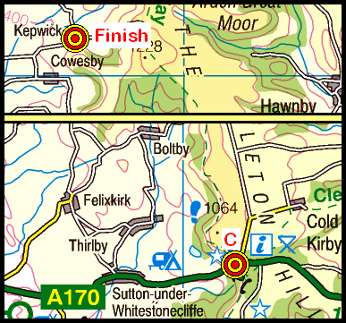
Following several consecutive trips to more distant locations, today's expedition (07-06-2009) brought us back onto our local terrain - the North York Moors. During the day we visited Garfitts, Beak Hills, Barker's Ridge, Arnsgill Ridge, Brewsters Hill and Thorodale before making our rendez-vous with the other two groups at Kepwick {SE 470 909}.
We set off from Clay Bank {NZ 572 035} (see the photograph below) at about 10.20 am. There were 9 people in the group: JB, PB, RB, KF, JG, JJ, PJ, JY, and PY. PJ led the walk.
From our starting point, we headed in a south-westerly direction towards Hasty Bank Farm {NZ 567 030} and then, further west, we passed Garfitts {NZ 563 031} on our left. We now turned onto a NW bearing. As we continued our NW trek, we skirted pass the Wain Stones {NZ 559 036} on our right (see the following picture) as we made our way towards the Cleveland Way.
We stayed with the Cleveland Way for about 175 yards. At {NZ 554 034} we turned onto a south-westerly bearing in order to make our way to Beak Hills {NZ 547 025}, Hall Garth {NZ 541 017} and Raisdale Mill {NZ 538 005}. From here, we began our climb up onto Barker's Ridge. We picked up a good track at {NZ 523 003} and followed this to {SE 535 984} where we had a very pleasant lunch stop - just north of Osmotherley Stones.
After lunch, we continued along our track in a southerly direction to Head House {SE 534 971} and onwards across Cow Ridge. We continued on a southerly bearing until we reached a minor road at {SE 527 939}. We then followed this (downhill) in a southerly direction passing Lane House (Snilesworth) at {SE 527 938}. We left the minor road at {SE 528 932} in order to follow a path through Green's Wood in order to reach Brewster Hill {SE 525 924}. Continuing on our southerly trek, we passed through Blueberry Wood to arrive at Harker Gates {SE 527 914} and Mount Pleasant.
Just after Mount Pleasant, at {SE 525 910} we took a right-turn into Thorodale. Following a westerly bearing, we passed by Arden Hall {SE 520 909} on our left and then picked up a well-defined track. Chasing the track in a NW direction, we climbed up through North Moor Woods in order to reach our point of exit at {SE 502 916}. We now made a short descent to {SE 498 917} before we were confronted with the final climb of the day - up to {SE 495 919} where we took a short tea stop.
After our short break we continued our westerley trek in order to reach the Cleveland Way at {SE 490 919}. Turning south, we stayed with this until we reached a track on our right {SE 489 909} that took us down to Gallow Hill {SE 485 899}. At this point we turned onto a north-westerly bearing and made for Pen Hill {SE 470 904}. As we dropped down over Atlay Bank we saw a tremendous display of pink rhododendron bushes. Meeting the minor road at {SE 466 908}, we turned right andfollowed the road into the village of Kepwick where our coach was waiting for us.
We had a great day and a superb walk. However, the weather was very different from what we experienced during our previous walk. Today, we were back to winter conditions!
Use the buttons below to see where we went, how we did and some of the sights we saw.
Many thanks to PJ for organising such an interesting and exciting adventure for us today. We had a really great time.
On Sunday, 14th June, the Stockton Rambling Club will have three walks in the Swaledale area of North Yorkshire. All walks will finish in Richmond {NZ 168 011} - see the following map.
Crown Copyright 2009. All rights reserved. Licence No. 100046831. Produced using Anquet Maps.
The A-walk will start at Reeth {SE 038 993} and will take in Booze, Washfold, Orgate, Marske and Applegarth.
The B-walk will commence at Grinton {SE 047 984} and will visit Marrick Park, Hollins Farm, Skelton Lane and Marske.
The C-walk will set off from Downholme Bridge {SE 114 992} and will pass through Marske, Willances Leap and Round Howe.
This is a Route 2 coach pick up (Billingham: 9.30 am, Acklam: 9.45 am and Stockton: 10.00 am).
Some short while ago I did a stroll along part of the Cleveland Way - the part that passes through Whitby. The map below shows the area involved:
Crown Copyright (2009). All rights reserved. Licence No. 100046831. Produced using Anquet Maps.
The numbered 'yellow' spots (with a red surround) denote locations at which I took some photographs. Moving the mouse cursor over a yellow spot will display the title of the photo(s) that were taken at that particular location. By 'clicking' on one of the numbered yellow spots you should be able to see the actual photograph(s) that were taken from that viewing point. The photographs should display in "full screen" mode. However, the screen appearance will depend upon the type of browser being used and how it is configured. If you are using Mozilla Firefox or Internet Explorer you may need to press the F11 function key to see the pictures in full-screen mode. The F11 key also activates full-screen mode for most other browsers.
This year, our local long-distance national trail - the Cleveland Way (CW) is 40 years old. In order to celebrate this event, the North York Moors National Parks Authority has produced a special commemorative badge.
Most people in SRC will probably have walked along one or more sections of the CW at some time or another. Undoubtedly, there will be many happy memories of hours spent plodding along its route.
Click this link to see some recollections of doing the CW.
Click this link to see a photograph of the commemorative badge and a few photos which show what some of our SRC members have been doing in order to keep our local national path in good nick.
During the week beginning 8th June, Stockton Rambling Club will have TWO mid-week walks available. One is an evening walk and the other is a day walk.
The evening walk is on Wednesday, 10th June and will take the form of a Treasure Hunt. It will start at 6.50 pm from the main entrance to Saltburn Railway Station {NZ 664 214} at the end of Station Street - see the picture below.
This walking involved in this event will not exceed 6 miles. Please ring 01642-880261 for more details.
The day walk is on Thursday, 11th June. It will start at 10.30 am from Great Ayton Tourist Information Centre (High Green) car park {NZ 562 106} - see the map below. Use the postal code {TS9 6BJ} in your car's 'sat-nav'.
The length of this walk will be up to 10 miles. Please telephone 07892-908201 for more details.
It has been quite a while since we last walked in the Coquetdale area of Northumberland. This trip to Rothbury was therefore a very welcome event - and the weather was superb.
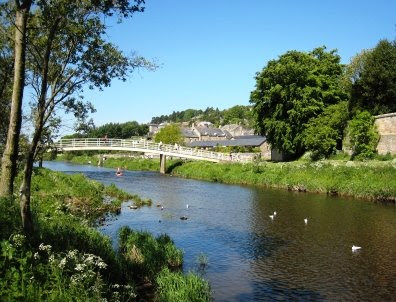
Our route today (2009-05-31) took us on a circular trek from Rothbury {NU 057 015} to The Beacon, Simonside, Chartners, Bickerton and Summerville. We set off at about 11.00 am from the car park on the bank of the River Coquet (see the picture below). There were 10 of us in the group: JB, LB, PB, RB, CH, PJ, WM, GT, JY and PY. WM led to walk.
From the riverside car park we turned into a narrow lane at {NU 059 015} and began our climb up to the small village of Whitton. Leaving the village on a southerly bearing, we passed Sharpe's Folly on our right and crossed Whitton Dean at {NU 058 002}. Following our climb up towards Garleigh Moor, we entered 'Cup & Ring' terrain. Although we looked on quite a few rocks, we could not see any of these interesting markings.
Click here and/or here to find out more about these fascinating rock markings and bronze-age Northumberland - including a photographof a 'real' stone circle!
We continued our southerly trek until we reached {NZ 058 992} where we took a south-westerly bearing in order to reach the car park on the minor road {NZ 052 988} just to the west of Lordenshaw. From here we had our first major climb of the day - up onto The Beacon {NZ 046 986}. Now keeping our westerly bearing, we continued to climb up to Dove Crag {NZ 037 985}. As we walked west, we had some tremendous views of the surrounding Northumbrian countryside. Our next climb took us up onto Old Stell Crag {NZ 030 984}. We stopped for lunch on the western side of the crag {NZ 271 985}.
After our lunch break, we continued onwards to the highest point of the walk (about 1400 ft) - the cairn on Simonside itself {NZ 024 987}. From here we had a short, very steep descent down to the edge of the forest at {NZ 021 988} where we picked up a very well-defined forest track. We followed this in a south-westerly direction to reach Chartners {NZ 002 957} and the 'Border Country Ride'. Here we turned onto a northerly (becoming north-westerly) bearing which took us pass a number of 'stunning', colourful rhododendron bushes.
We emerged from the forest at {NY 994 970} and, keeping our NW bearing, headed for Whitefield Hill {NY 986 974}. Just beyond this, at {NY 980 981} we turned through 90° onto a NE bearing and started our descent to the low ground near the River Coquet. As we approached Hepple Whitefield, we noticed what we thought were 'stone circles' in a field to the east of Whitefield Burn. WM later revealed what they really were!
After passing through Hepple Whitefield Farm we joined the minor road at {NY 987 996} and followed this in a north-easterly direction to Bickerton {NT 996 002}. Here we picked up a public footpath that took us across to the lake at Caistron {NT 997 006} where we were happy to take a short tea stop - watching the geese and swans.
Following our short stop, we continued on our NE trek along the side of the lake and then swung east to re-join the minor road near Ryehill. We continued along the road to a point just beyond Summerville {NU 034 010} where we turned left onto a permissive track. This took us to a footbridge at {NU 043 012} where we made our first crossing of the River Coquet. Heading towards the B6341 road, we followed a good footpathalong the northern bank of the river that took us back to Rothbury. Using the footbridge at {NU 057 015} (see the picture below) we crossed the River Coquet for a second time in order to get back to our coach which was waiting for us in the car park.
As we were back about 15 minutes early, some of us took advantage of the river in order to cool our aching feet.
Durng the course of today's walk I took a total of 63 photographs! Bearing in mind that we were walking for about 6 hours, that works out at about 10 per hour or, one every six minutes! This interesting statistic reflects what wonderful scenary and happenings we encountered.
Use the buttons below to see where we went, how we did and a selection of the photographsthat were taken.
Many thanks to WM for taking us on such a splendid walk and sharing with us his research into the 'stone circles' that we saw as we approached Hepple Whitefield.
On Sunday, 7th June, the Stockton Rambling Club will have three walks in the South-Western area of the North York Moors. All walks will finish in Kepwick {SE 467 908} - see the following map.
Crown Copyright 2009. All rights reserved. Licence No. 100046831. Produced using Anquet Maps.
The A-walk will start at Clay Bank {NZ 572 035} and will take in Carlton Bank, Arnsgill Ridge and Brewster Hill.
The B-walk will commence at Chop Gate {SE 558 993} and will visit Cock Howe [ :-( ], Brewster Hill and Arden Bank.
The C-walk will set off from Sutton Bank {SE 514 829} and will pass along part of the Cleveland Way and then visit Steeple Cross and Gallow Hill.
This is a Route 1 coach pick up (Billingham: 9.30 am, Stockton: 9.45 am and Acklam: 10.00 am).


 The length of this walk will be up to 10 miles.