On Sunday, 6th June, the Stockton Rambling Club will have three walks in the Howgill Fells area of Cumbria. All walks will finish in Sedbergh {SD 657 921} - see the following map.
Crown Copyright (2010). All rights reserved. Licence No. 100046831. Produced using Anquet Maps.
The A-walk will start from the A683 near Bridge Cottages {SD 716 981} and will take in Murthwaite, Green Bell, Yarlside, The Calf and Lockbank Farm.
The B-walk will commence at Cross Keys {SD 697 966} and will visit Cautley Spout, The Calf, Thwaite, Dales Way and Brigflatts.
The C-walk will set off from Rawthey Bridge{SD 713 979} and will pass through Birks, Hebblethwaite Hall, Dovecote Hill and Millthrop.
This is a Route 2 coach pick up and is also an early start (Billingham: 9.00 am, Acklam: 9.15 am and Stockton: 9.30 am).
Our three expeditions this week (Sunday, 23rd May) should have taken place in the Ribblesdale area of North Yorkshire within the Yorkshire Dales National Park. Unfortunately, as a consequence of a motor-cycle accident on the B6255 road (see here), our route from Hawes to Ingleton was closed - thereby preventing us from getting to the starting points for our walks. These therefore had to be cancelled. Instead, we had to organise three impromptu 'surprise' walks from Hawes.
After leaving Hawes {SD 874 898}, the intent of the C-Walk was to visit Sedbusk, North Rakes Hill, Pike Hill, Shivery Gill, High Shaw and Hardraw before returning to our final destination in Hawes {SD 876 898}.
As it was now approaching mid-day, before setting off on our expedition we decided to take a short lunch break in the playground/park area in the east end of Hawes {SD 874 897}. There were some convenient park benches here and this also gave the leader a few minutes to plan out the afternoon's activity.
After lunch, we set off from our starting point at about 12.15 pm. There were twelve people in the group: PB, VF, JH, KH, DK, FM JM, CR, RR, BW and LW. PB led the walk.
From the A684 road (see the picture above) we set off in a northerly direction along Brunt Acres Road - following the route of the Pennine Way (PW). We crossed the River Ure using the road bridge at {SD 876 903} - Haylands Bridge. At {SD 877 905} we left Burnt Acres Road by following a north-easterly footpath on our right. This took us across the field, over a quaint stone footbridge and then uphill to a minor road at {SD 880 908}. From here we continued on our north-easterly bearing until we reached Sedbusk Lane at {SD 883 910}. Turning left we continued uphill along the lane into the small village of Sedbusk {SD 883 911}.
Leaving the village on a north-easterly trek, we made our way uphill along Shutt Lane to reach {SD 889 916}. As we progressed up the route of the walled bridleway we had some tremendous views of the Hawes area to the south of us. We also had some good views of the impressive scars that lay ahead of us (to the north): High Clint (to our left) and Little Fell Clint (to our right). Leaving {SD 889 916} we headed north (again uphill) to reach a gated wall at {SD 889 918}. Our track now zig-zagged a little and then climbed up onto the high ground near Little Fell Clint {SD 889 921}. Returning to our northerly bearing, we continued our trek to reach {SD 889 924} at the southern end of Abbotside Common. As we moved north, we had some good views of Smuker Hill {SD 887 921} on our left - see the picture below.
Having reached Abbotside Common, the major part of the climbing was now over. We were now able to enjoy some very pleasant cool breezes as we walked north. At {SD 889 924} we turned left and went along a good track in a westerly direction. This led us into the final (gentle) climb of the walk - up onto North Rakes Hill {SD 883 924}. We paused here to admire the views and also take a short drink stop. Looking in a north-north-easterly direction, we could see the trig point on Great Shunner Fell.
Continuing our trek in a westerly direction we made our way across the high ground towards the cairns on High Clint. At {SD 875 924} we changed to a north-westerly bearing and moved along the contours to reach the two cairns near Pike Hill {SD 869 931}. There were some quite spectacular views to the west and south-west from here. Maintaining our north-westerly bearing, we followed a poorly defined footpath to reach Shivery Gill {SD 868 935} - see the following picture.
About 85 yards further north we turned left and followed the footpath downhill to join a minor road at {SD 865 936}. Turning left, we followed this downhill (in the direction of Hawes) until we reached a gate on our right at {SD 866 926}. We used this to gain access to a convenient field where we stopped for a short tea break. Again, from our vantage point, we had some good views of the Hawes area below us.
After our tea stop, we continued downhill along the road to find a footpath on our right at {SD 867 924}. Taking this path we continued downhill across the fields towards a small stream at {SD 865 922} near Strands. The path now took us in a south-easterly direction (passing a caravan site on our right) to reach the road at {SD 869 919} near High Shaw. We stayed with the road for about 120 yards and then turned left along a footpath at {SD 869 918} that took us to a path junction at Low Shaw {SD 871 917}. Now turning onto a bearing of 207°, we dropped down to the road near Simonstone {SD 871 916}. Continuing on a bearing of 218° (roughly, south-west) we made a steep descent down to the village of Hardraw {SD 867 912} where we stopped for a short late-afternoon refreshment break at the Green Dragon hostelry.
The final part of our walk took us from Hardraw along the PW in a southerly direction towards and into Hawes. As we went south along Burnt Acres Road, we had some picturesque views of the River Ure (as depicted in the scene below).
We continued along the PW and Burnt Acres Road towards its junction with the A684 road. Just before the junction we turned left into the car park and found our coach waiting for us at the far end.
Despite the unexpected and surprising events of the early part of the day, we managed to organise an interesting and exciting adventure centred around the Hawes area. We had a really great time - of course, the wonderful weather helped.
Use the buttons below to see where we went, how we did and some of the pictures.
On Sunday, 30th May, the Stockton Rambling Club will have three walks in the South-Western area of the North York Moors. All walks will finish at the Flask Inn {NZ 930 007} on the A171 road - see the following map.
Crown Copyright (2010). All rights reserved. Licence No. 100046831. Produced using Anquet Maps.
The A-walk will start at Selly Hill {NZ 857 093} and will take in Littlebeck, Robin Hood's Bay, Boggle Hole and Spring Farm.
The B-walk will commence at Whitby {NZ 893 103} and will visit Stainsacre, Raw, Robin Hood's Bay and Boggle Hole.
The C-walk will set off from Sneaton Corner {NZ 916 037} and will pass through Skerry Hall, Raw, Robin Hood's Bay and Boggle Hole.
This is a Route 1 coach pick up (Billingham: 9.00 am, Stockton: 9.15 am and Acklam: 9.30 am).
Our three expeditions this week (Sunday, 16th May) each took place in the Rosedale area of the North York Moors. The A-Walk set off from Rosedale Head near Ralph's Cross, the B-Walk started just south of the Lion Inn on Blakey Ridge and the C-Walk commenced at Hutton-le-Hole.
After leaving the Ralph's Cross area {NZ 677 020} (see the picture below), the intent of the A-Walk was to visit Wether Hill, Dale Head Farm, Thorgill, Rosedale Abbey, Yatts Farm and Muffles Rigg before arriving at our final destination in Cropton {SE 755 888}.
We left our drop-off point near Ralph's Cross at about 10.45 am. There were six people in the group: JB, PB, KF, AM, LM and JP. PB led the walk.
From the road junction at Rosedale Head we followed the road in an easterly direction until we reached White Cross. Turning right we made our way south to Wether Hill {NZ 682 017}. Now using an easterly bearing we navigated our way across the heather back to the road at {NZ 685 017}. After crossing the road we followed a line of very nicely painted ('white-topped') boundary markers over the moorland until we reached a south-going footpath at {NZ 698 010}.
Leaving the road on a southerly bearing we made our way to Sturdy Bank and descended down to the dismantled railway track at {SE 698 998}. Crossing this, we continued our descent to Dale Head Farm {SE 695 992}. From here we followed Dalehead Road in a southerly direction until we reached the road junction just beyond Red House Farm {SE 696 988}. Turning right we made our way in a westerly direction towards Moorlands Farm {SE 691 989}. Just before the farm we turned left onto a gated track - Daleside Road (Track).
We followed the track in a south-easterly direction to Thorgill {SE 707 965} and then took a footpath across the fields at {SE 709 963}. Rejoining Daleside Road at (SE 714 963} we continued along it in a south-easterly direction, passing Thorgill House {SE 717 959} and Hobb Farm {SE 718 958} on our right. After passing the second of these landmarks, we turned left and followed a footpath across a field to reach a footbridge at {SE 721 959}. We crossed the River Seven and sat in a sunny spot on its eastern bank for a short lunch stop (SE 721 959}.
From our lunch-stop location we walked into Rosedale Abbey {SE 724 959} - passing through the church-yard as we went (see the above picture). With the Abbey Teashop on our left, we made our way towards Alder Carr Lane where we turned right - passing over the River Seven using the road bridge at {SE 724 957}. We now followed a footpath uphill across the fields to reach the entrance to the golf course on Daleside Road (SE 722 955}.
Turning left along the road we made our way to the road junction at {SE 723 954}. Keeping the hotel on our right, we headed south along a good track towards Newlands Farm {SE 725 952}. We stayed with this track until we reached {SE 731 945} (just before Hollins Farm) where we turned left onto a downhill footpath. This took us to a bridge over the River Seven and then led us uphill to Yatts Farm {SE 736 951}. As we approached the farm we found that some 'unofficial' footpath diversions had been put in place here.
After crossing Pry Hills Lane we climbed up towards Allotment Farm {SE 740 951} where we found that more path re-routing had been put in place. However, these were official and were appropriately sign-posted with footpath markers. From the farm access road at {SE 742 948}, and subsequent to a minor navigational error, we navigated a route through the woods to reach Hancow Road at {SE 748 944} where we paused for a short 'drink stop'.
Moving off in a north-easterly direction, we trekked through a wonderful wooded area to reach a minor road at Rock House {SE 754 948}. Following the road in a southerly direction, we progressed along it until we reached a road junction at {SE 757 941} where we turned left. We now had a very steep descent towards Hartoft Beck {SE 759 942}. Just before the river we turned right and made our way to Muffles Bridge where we stopped for a short tea stop {SE 760 941}.
On leaving the tea-stop venue, we made our way to Low Muffles where we turned left at {SE 761 940} and climbed up through the forest to reach a very broad forestry track on Muffles Rigg {SE 766 940}. Turning to our right, along the track, we followed this in a southerly direction to Sutherland Road {SE 765 919}. We maintained our southerly trek until we came to a track junction at {SE 767 907} where we made a right turn. We maintained our new bearing of 262° for about 570 yards and then, turning left, returned to our southerly trek. This took us over Sutherland Beck {SE 762 904} and up to Fall Rigg {SE 762 900}.
At {SE 762 899} we changed our bearing to take us in a south-westerly direction into our final climb of the day at Cropton Banks. We joined High Lane at {SE 759 896} near the northern end of Cropton. From here we had an easy walk through the village in a southerly direction to reach our coach, and subsequently, the local hostelry {SE 755 888} - see the picture below.
We had an interesting and exciting adventure today. Despite one or two very minor navigational slips and re-routes, we had a really great time.
Use the buttons below to see where we went, how we did and some of our pictures.
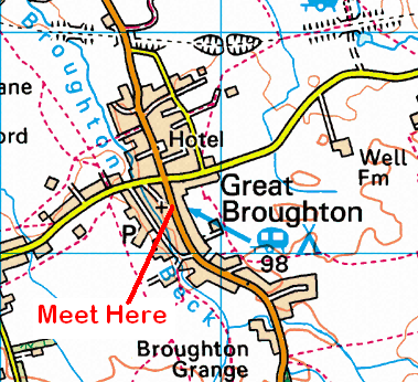
On Sunday, 23rd May, the Stockton Rambling Club will have three walks in the Ribblehead area of North Yorkshire. All walks will finish in Ingleton {SD 695 729} - see the following map.
Crown Copyright (2010). All rights reserved. Licence No. 100046831. Produced using Anquet Maps.
The A-walk will start at Ribblehead {SD 765 792} and will take in Ingleborough, Gaping Gill and Clapham.
The B-walk will also commence at Ribblehead and will visit Slack Hill, Whernside, Ellerbeck and Beezleys .
The C-walk will set off from Selside {SD 788 746} and will pass through Sulber Gate, Long Scar, Clapham and Newby.
This is a Route 2 coach pick up and is also an early start (Billingham: 9.00 am, Acklam: 9.15 am and Stockton: 9.30 am).
John Carter has sent me a sample of the wonderful photographs that he took during the B-Walk's expedition to Coniston via Wetherlam on Saturday, 8th May as part of the SRC's weekend activities at Ambleside.
Our three expeditions on Day-2 of our Lakes trip (Sunday, 9th May) each took place in theAmbleside area of the south-eastern region of the Lake District (OS Explorer Sheet 7). The A-Walk set off from Ambleside, the B-Walk started at Ambleside Youth Hostel and the C-Walk commenced at Grasmere. All three walks terminated at the youth hostel in Ambleside.
After leaving the car park in Ambleside {NY 375 047}, the intent of the A-Walk was to visit Kirkstone Road, Snarker Pike, Red Screes, Scandale Pass and High Sweden Bridge before returning to Ambleside and then making our way to our final destination at Ambleside Youth Hostel {NY 376 030}.
We left our drop-off point near the car park (see the picture below) at about 09.30 am.
There were eight people in the group: JB, PB, RB, JH, KF, LM, WM and FEW. WM led the walk.
From the car park we navigated an uphill route around the north-west side of Ambleside in order to reach Kirkstone Road at {NY 382 049}. Turning left, we walked uphill, pass the entrance to Roundhill Farm, for about 610 yards until we reached a footpath on our left at {NY 385 053}. This took us uphill in a northerly direction to the ladder stile at {NY 387 070} near Flesh Crags. Keeping the wall on our right, we climbed up towards Pets Quarry and stopped at {NY 388 070} for a short 'refreshment break'.
Continuing our climb in a north-north-easterly (NNE) direction, we made our way to Snarker Pike {NY 390 075} - from where we had some good views of Kirkstone Pass - far below us! We continued on our NNE bearing until we reached {NY 390 078} near Pets Brae. We now turned onto a north-easterly bearing which we maintained until we reached the trig point on Red Screes {NY 396 087} - see the picture below.
We sat in the shelter on Red Screes for a few minutes and discussed where we should go next. WM decided that we should add a short extension to our route and, in so doing, take in Middle Dodd - which lay to the north of us. Setting off from Red Screes, we followed the ridge along Smallthwaite Band until we arrived at Middle Dodd {NY 397 096}. From here, we had some good views of Brother's Water.
We now re-traced our steps back along Smallthwaite Band until we reached {NY 396 094}. From here, we navigated a route 'along the contours' in order to get to the stone wall at {NY 389 091} near Broad Crag. Descending in a north-westerly direction, we made our way to the ladder style at {NY 387 095} in Scandale Pass where we stopped for a short lunch break.
Leaving our lunch-stop location, we trekked downhill in a southerly direction towards Scandale Bottom. As we descended, there were some good views of Scandale Beck ahead of us. More or less, our route now followed the course of the beck until we reached High Sweden Bridge {NY 379 067} where we decided to take a short tea stop sitting beside the stream. During the time we spent there we were pleasantly entertained by a female duck!
After crossing the bridge, we undertook the final (short) climb of the day. We trekked in a south-westerly direction to the tarn at {NY 376 066} and then turned back onto a southerly bearing that took us to Low Sweden Bridge {NY 375 055}. The track from here took us to Nook End Farm {NY 375 054}. From here we followed a good road downhill, passing a University of Cumbria building on our right, until we reached the car park near the A593 road in Ambleside - from where we originally started our expedition earlier in the day.
From the car park we navigated a route through the centre of Ambleside and made our way along the A591 road in a southerly direction to reach the Youth Hostel at {NY 376 030} - see the picture below.
Many thanks to WM for organising such an interesting and exciting adventure for us today. We had a really great time - the 'add-on' to Middle Dodd was especially nice.
Use the buttons below to see where we went and how we did - and browse through some of the photos.
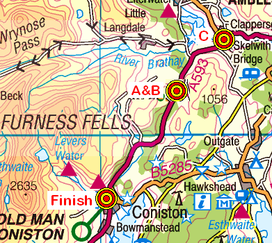
Our three expeditions on Day-1 of our Lakes trip (Saturday, 8th May) each took place in the Furness Fells area of the south-central region of the Lake District (OS Explorer Sheets 6 and 7). The A-Walk set off from High Cross (near Oxen Fell) on the A593 road {NY 328 017}, the B-Walk started nearby at {NY 329 022} and the C-Walk commenced at Skelwith Bridge. All three walks finished in Coniston {SD 304 976}.
After leaving High Cross {NY 328 017}, the intent of the A-Walk was to visit High Tilberthwaite, Wetherlam, Swirl How, Levers Hawse and The Old Man of Coniston before arriving at our final destination in Coniston {SD 304 976}.
We left our drop-off point at about 09.40 am. There were eight people in the group: JB, PB, RB, MC, JH, KF, LW and FEW. RB led the walk.
After an initial ascent in a north-north-westerly direction along a good track, we swung onto a westerly bearing and dropped down into High Oxen Fell {NY 323 018}.
Continuing on our westerly trek we made our way to {NY 319 019} where we turned left onto a south-westerly bearing. We maintained this bearing following a path along the north-western edge of Furness Fells until we reached Holme Ground {NY 311 011}. From here we navigated a route in a north-westerly direction to join a minor road at High Tilberthwaite {NY 308 013}. Turning left, we followed this to Low Tilberthwaite {NY 305 011} where we took a public footpath on our right. We followed this to Tilberthwaite Gill (on our left) {NY 300 007} and then continued climbing in a north-north-westerly direction to near Birk Fell {NY 295 017} where we turned onto a south-westerly (SW) bearing.
From here, we climbed up along Wetherlam Edge to reach our first summit of the day on Wetherlam (762 m) {NY 288 011}. Maintaining our SW bearing, we made our way across Prison Band to reach Swirl How {NY 272 005}. From our lunch location we had a good view south towards our next destination (The Old Man of Coniston) - see the picture below.
After our lunch stop we made a southerly trek to Great How Crags {SD 273 999} and, after stopping to admire the view, continued on to Levers Hawse {SD 270 994}. As we went south, we had some good view of Levers Water (on our left) and Seathwaite Tarn (on our right). Continuing in a southerly direction we eventually reached the final summit on our expedition: The Old Man of Coniston (803 m) {SD 272 978}.
From the summit, our steep descent path took us in a north-easterly direction towards Low Water - see the picture below. When we reached the tarn we decided that we would stop for a short tea break near its eastern extremity {SD 275 982}.
As we left the lake and descended in an easterly direction to Crowberry Haws we saw extensive evidence of the mining and quarrying that had taken place in this area in bygone days. There were also some impressive waterfalls to be seen as we looked north towards the Coniston Fells.
We continued our descent in an easterly direction until we reached Church Beck {SD 293 981} when we turned onto a south-easterly bearing. We maintained this bearing until we arrived at the outskirts of Coniston {SD 300 975}. From here we had just a short easterly stretch to the A593 road and the car park {SD 303 975} in which our coach was waiting to take us back to Ambleside Youth Hostel
Many thanks to RB for organising such an interesting and exciting adventure for us today. We had a really great time - the climbs were hard but the views were terrific. Use the buttons below to see where we went, how we did and some of the photos.
On Thursday, the 20th May the Stockton Rambling Club will hold a special mid-week event. This will involve a visit to the Himalayan Garden in Ripon. Following the visit there will be an optional walk of up to 6 miles.
The cost of the visit will be £5-50. For further details and bookings, please ring 01740-644347.
On Sunday, 16th May, the Stockton Rambling Club will have three walks in the Rosedale area of the North York Moors. All walks will finish in Cropton {SE 757 891} - see the following map.
Crown Copyright (2010). All rights reserved. Licence No. 100046831. Produced using Anquet Maps.
The A-walk will start at Ralph's Cross {NZ 677 019} and will take in Wether Hill, Dale Head Farm, Rosedale and Muffles Rigg.
The B-walk will commence at the Lion Inn on Blakey Ridge {SE 680 996} and will visit Dale Head Farm, Thorgill, Rosedale and Muffles Bridge.
The C-walk will set off from Hutton-le-Hole {SE 706 899} and will pass through Mary Magdelene Well, Camomile Farm and Hartoft Bridge.
This is a Route 1 coach pick up (Billingham: 9.30 am, Stockton: 9.45 am and Acklam: 10.00 am).
On Sunday, 9th May, the Stockton Rambling Club will have three walks in the Ambleside area of the Lake District - see the following map. All walks will finish at Ambleside Youth Hostel {NY 376 030}.
Crown Copyright (2009). All rights reserved. Licence No. 100046831. Produced using Anquet Maps.
The A-walk will start at Kirkstone Road {NY 376 047} and will take in Red Screes, Scandale Pass and Ambleside. This walk will involve a distance of 9 miles and an ascent of 2500 feet.
The B-walk will commence at the Youth Hostel {NY 377 030} and will visit Troutbeck, The Hundreds, Wansfell Pike and Ambleside. This walk will involve a distance of 7.5 miles and an ascent 1900 feet.
The C-walk will set off from Grasmere {NY 337 075} and will pass through Rydal Water and Ambleside. This walk will involve a distance of 7.5 miles and an ascent 950 feet.
On Saturday, 8th May, the Stockton Rambling Club will have three walks in the Furness Fells area of the Lake District. All walks will finish in Coniston {SD 303 976} - see the following map.
Crown Copyright (2009). All rights reserved. Licence No. 100046831. Produced using Anquet Maps.
The A-walk will start at High Cross on the A593 {NY 339 053} and will take in Tilberthwaite, Wetherlam, Swirl How and Coniston Old Man. This walk will involve a distance of 9.5 miles and an ascent of 3300 feet.
The B-walk will also commence at High Cross and will visit Tiberthwaite, Wetherlam and Hole Rake. This walk will involve a distance of 7 miles and an ascent of 2200 feet.
The C-walk will set off from Skelwith Bridge {NY 345 033} and will pass through part of the Cumbria Way, Tarn Howes and Yewdale. This walk will involve a distance of 6.5 miles and an ascent of 1000 feet.
The SRC weekend will take place on the weekend of the 7th May. We will be staying in Ambleside Youth Hostel {NY 376 030} in the Waterhead area - see the following map.
This is a Route 2 coach pick (Billingham: 6.15 pm, Acklam: 6.30 pm and Stockton: 6.45 pm).
Our three expeditions this week (Sunday, 2nd May) each took place in the Wharfedale area of North Yorkshire. Both the A-Walk and the B-Walk started at Hebden and the C-Walk commenced at Grassington. All three walks finished in Kettlewell.
After leaving Hebden {SE 026 632}, the intent of the A-Walk was to visit Grassington, Yarnbury, Kelber, Mossdale, Sandy Gate, Blake Hill, Great Whernside and Providence Pot before arriving at our final destination in Kettlewell {SD 968 723}.
We left our drop-off point at about 10.50 am. There were seven people in the group: JPB, PB, RB, KF, CH, JH and LM. PB led the walk.
From our drop-off point on the B6265 road in Hebden, we set off in a south-easterly direction along Mill Lane (see picture above) towards the stepping stones and suspension bridge near Mill Bridge {SE 026 624}. At this point we turned right along a public footpath that took us to the River Wharfe {SE 024 624} where we joined the Dales Way long-distance footpath. We followed this in a westerly direction along the side of the river to meet the B6265 road in Grassington {SD 998 639}.
Turning onto a north-easterly bearing we passed through the north-west part of the town to join a minor road at {SE 003 642}. We followed this uphill (passing a covered reservoir on our right) to reach Spring House {SE 009 647}. Continuing along Moor Lane in a north-north-easterly direction, we passed Mire House {SE 011 650} on our right and continued on to Yarnbury {SE 015 659}.
Just after passing Yarnbury Grange, we turned left onto a north-westerly bearing and followed a good, walled-track. As we went along this, there was extensive evidence on our left of the extensive mining that once took place in this area. At {SE 008 669}, we passed High Barn on our left and continued in a northerly direction over Downs Pasture. A little further north, near Seeds Hill {SE 007 680} we decided to take advantage of what cover there was and stop for a short lunch break.
After lunch, we continued on our northerly trek to reach Kelber where we met a track junction at {SE 005 686}, Turning right onto a north-easterly direction we passed over the dried-up ford at Bycliffe {SE 010 692} and continued onwards to Mossdale. There were some impressive views of Mossdale Scar {SE 016 698} as we passed through the dale. We crossed Mossdale Beck near the ford at {SE 020 701} - see the picture below.
From the ford we had a good climb up to the stone shelter at {SE 026 708} where we paused for a quick 'drink stop'. Continuing on from the shelter, we made our way up to the boundary fence at Sandy Gate {SE 030 712} where we turned left onto a northerly bearing. Keeping the fence on our left, we trekked over rough moorland terrain until we reached {SE 031 720}; we now changed onto a bearing of 321°. Maintaining this bearing, we passed over Blake Hill {SE 025 729} and continued, still with the boundary fence on our left, to {SE 019 736}.
At this point we turned left and headed in a westerly direction. Our route now involved making our last climb of the day - up onto the high ground at Stone Head Crag {SE 009 734}. There were now some strong cold winds blowing. However, the rocks that we found there provided some good cover for our tea stop. From our vantage point, we had some tremendous views to the east: Angram Reservoir and Scar House Reservoir were clearly visible far below us.
On departing from our tea stop location, we made our way west towards the two cairns on the southern edge of Great Whernside. Now taking a bearing of 328° we navigated our route to reach the trig point at {SE 002 739} - OSBM 2976. There were some magnificant views to the west from here - including one of our forthcoming destination in Kettlewell.
Leaving the trig point on Great Whernside, we descended from the high ground in a west-south-westerly direction towards Hag Dike {SD 990 733}. From here we continued our descent (now in a south-south-easterly direction) until we reached Providence Pot {SD 992 729}. We found an interesting vertical mine-shaft here - probably used by pot-holers. To see a picture of the entrance, click here; to look down inside, click here.
We were now at the bottom of a steep-sided V-shaped valley through which ran Dowber Gill Beck. We followed the course of the stream in a westerly direction towards Kettlewell {SD 968 723} and the Racehorses Hotel (see picture below) - near to which our coach was waiting on the B6160 road ready to take us home.
We had another interesting and exciting expedition today which took us through some spectacular North Yorkshire scenery. Use the buttons below to see where we went, how we did and some of the photos.


 - looking west")