During the week beginning 3rd August, Stockton Rambling Club will have TWO mid-week walks available. One is an evening walk and the other is a day walk. There is also a 'special event' on Saturday, 8th August.
The evening walk is on Wednesday, 5th August and will start at 7.00 pm from Rectory Lane Car Park in Guisborough - see the map below.
This walk will be not be longer than 6 miles. Please ring 01325-469476 for more details.
The day walk is on Thursday, 6th August. It will start at 10.30 am from Danby Lodge Moors Centre - see the map below.
The length of this walk will be up to 10 miles (C pace). Please telephone 01642-299312 for more details.
The special event is on Saturday, 8th August and will take the form of an open-air ceilidh. It will take place at Preston Park Walled Garden between 6.00 pm and 9.00 pm. The cost is £5.00. Bring your own picnic, drinks and chairs. Bookings, with payments, to Bill McTimoney (01740-644347).
Saltergate {SE 852 945}, on the A169 road to Pickering, is famous for a number of reasons. One of these is its proximity to the Hole of Horcum - a popular tourist attraction (see the picture below). Then, of course, there is (or should I say there was?) the apparently haunted Saltergate Inn. Another reason, from a walking perspective, is the fact that it used to be the base for the Saltergate Circuit - an annual, 26-mile long-distance challenge walk on the North York Moors (the event now starts from Stape Outdoor Centre).
Today's A-walk (26th July, 2009) started just south of the inn at Saltergate - at the carpark that overlooks the Hole of Horcum (near the trees on the horizon in the above picture). Our route took us north to Littlebeck and then south-west to finish at Goathland.
We set off from the carpark at about 11.10 am. There were six people in the group: JB, PB, RB, KF, JH and WM. PB led the walk.
From the car-park we made our way to Old Wife's Way but soon turned left off this - heading north pass the trig point at {SE 855 940}. We then took a north-easterly bearing along Saltergate Brow in order to get to Malo Cross {SE 867 949}. This was the first of several old crosses that we passed during the course of the walk. At Malo Cross we turned north and headed for Eller Beck Head, passing RAF Fylingdales on our left (see here and/or here for more information).
At {SE 871 968} we turned east along Worm Sike Rigg. We kept our easterly bearing until we reached {SE 889 968} where we turned north and made our way to Lilla Cross {SE 889 987} (see picture below). We had our lunch stop here. It was now quite dark overhead and we were anticipating rain.
After lunch we travelled via Robin Hood's Bay Road (a path) making our way to the site of John Cross {NZ 900 027}. As we were walking along this part of the route we saw a beautiful example of an adder lying on the track ahead of us. Its markings were really superb. Sadly, before I could get my camera into action, it wriggled off at great speed into the undergrowth. Click this link for more about adders.
Turning west at John Cross, we now descended down to May Beck and then followed its course in a northerly direction to reach the tiny village of Littlebeck {NZ 879 049}. From here we had a good climb in a westerly direction to reach the A169 road at {NZ 862 048}. Just before reaching the road we stopped on some rocks for a short tea break. As we climbed there were some good views of Whitby and the sea to the east of where we were sitting.
After crossing the road we continued our westerly trek in order to reach a minor road at {NZ 845 051} - near Lowther's Crag. We now turned south and headed for Arundel Hill {NZ 838 037} and the minor road that lay to the south of it {NZ 836 032}. From the road we continued our southerly trek until we reached the North York Moors Railway {NZ 836 020}. Following this, we passed Mill Scar (on our left) to reach Goathland Railway Station where we crossed the railway track in order to get to our final destination in Goathland {NZ 833 013}.
After Saturday's hot and sunny weather, today's conditions were superb for A-walking: lots of cloud, cool breezes and occassional dashes of cool, refreshing mizzle. We made a minor amendment to our route at Black Brow so as to take in Lowther's Crag rather than visiting the trig point at {NZ 855 049} (see details here). This increased the overall length of the walk by about 0.2 mile. However, despite this, we still reached our destination with ten minutes to spare. Use the buttons below to see where we went, how we did and, some of the lovely things we saw.
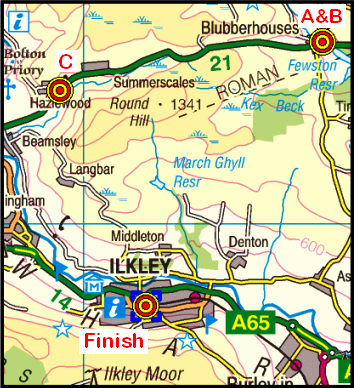
On Sunday, 2nd August, the Stockton Rambling Club will have three walks in the Wharfdale area of North Yorkshire. All walks will finish in Ilkley {SE 118 476} - see the following map.
Crown Copyright (2009). All rights reserved. Licence No. 100046831. Produced using Anquet Maps.
The A-walk will start at Blubberhouses {SE 170 554} and will take in Spittle Ings and Beamsley Beacon.
The B-walk will also commence at Blubberhouses and will visit Swinsty Reservoir, Ellercarr Pike and Dunkirk.
The C-walk will set off from near Hazelwood {SE 090 538} and will pass through Bolton Abbey and Addingham and then follow the River Wharf.
This is a Route 1 coach pick (Billingham: 9.30 am, Stockton: 9.45 am and Acklam: 10.00 am).
During the week beginning Monday, 27th July, Stockton Rambling Club will have TWO mid-week walks available. One is an evening walk and the other is a day walk.
The evening walk is on Wednesday, 29th July and will start at 7.00 pm from the Raby Arms in Hart Village {NZ 472 349} - see the map and photograph below.
This walk will be not be longer than 6 miles. Please ring 01642-715773 for more details.
The day walk is on Thursday, 30th July. It will start at 10.30 am from Sunderland Bridge {NZ 264 378} - see the map below.
Crown Copyright (2009). All rights reserved. Licence No. 100046831. Produced using Anquet Maps.
The length of this walk will be up to 10 miles. Please telephone 01740-644347 for more details.
"I galloped, they galloped, we galloped all eight!" 1
Sometimes, A-walks are often described as being something of a gallop! Of course, that's not really true - even though we do walk fairly fast. However, we had to go at quite a pace today because of the reduced walking time that was forced upon us (see the pink "Amendments to Route" button at the end of this posting for more details). Today's expedition (19th July, 2009) took us from the delightful Swaledale village of Healaugh {SE 018 990} in a northerly direction to Great Punchard Gill and then back on a southerly trek (via Jingle Pot Edge) to Gunnerside {SD 951 982}. Healaugh is located about 1.3 miles west of Reeth on the B6270 road.
We set off from the village at about 13.00 pm. There were 8 people in the group: JB, PB, RB, CH, JH, KF, JY and PY. PB led the walk.
We left Healaugh on an uphill, north-westerly bearing, following a minor road that took us first to Thirns and then to a track junction at {SE 008 997}. From here we took the right-hand track and headed for the relatively low ground between Cringley Hill and Calver Hill. At {NZ 004 009} we picked up a track that we followed in a north-easterly direction in order to join a minor road near Arkle Town {NZ 009 016}. We crossed Arkle Beck using the foot-bridge at {NZ 010 021} and then followed the river in a north-westerly direction to reach the small village of Langthwaite {NZ 005 025} - see the picture below.
We continued to follow the course of the river up through Arkengarthdale until we reached the tiny village of Whaw {NY 982 045}. We used Whaw Bridge in order to cross Arkle Beck and then headed west (via Whaw Bents) to reach Great Punchard Gill - our destination now being the old disused Punchard Coal Level at {NY 946 042}. From here, we headed south over Punchard Moor to reach a path junction at {NY 951 030}. At this point we changed our bearing to head in a SW direction to pick up a track at {NY 957 014}. Turning right along this, we passed the Old Gang Mines on our left as we headed west towards Gunnerside Gill.
After crossing the gill at {NY 938 021} we turned left and headed in a southerly direction towards Lownathwaite Lead Mines and then Botcher Gill Gate {NY 934 006}. Just after this point we were confronted with our final climb of the day. This took us up onto Jingle Pot Edge {SD 933 996}. From here we had some terrific views. Now heading in a SW direction, from here it was down hill all the way to the end of the walk at the small village of Gunnerside {SD 933 996} - a place that I have often visited in the days when I used to compete in the Swaledale Marathon (see the 'Memories' button below).
Despite the reduced walking time, we managed to get in a reasonable walk and also arrived back in time for refreshments at the Kings Head. Use the buttons below to obtain more details of our expedition.
Notes: 1Adapted from Robert Browning - "How they carried the Good News from Ghent to Aix."
Sunday Walking with SRC: Three Routes to Goathland
On Sunday, 26th July, the Stockton Rambling Club will have three walks in the Central Region of the North York Moors. All walks will finish in Goathland {NZ 832 013} - see the following map.
Crown Copyright (2009). All rights reserved. Licence No. 100046831. Produced using Anquet Maps.
The A-walk will start at Saltergate {SE 852 938} (near the Hole of Horcum) and will take in Lilla Cross, John Cross and Littlebeck.
The B-walk will also commence at Saltergate and will visit Lilla Cross, Simon Howe, and Wheeldale.
The C-walk will set off from near Sleights {NZ 866 068} and will pass through Lilla Howe and Simon Howe.
This is a Route 1 coach pick (Billingham: 9.30 am, Stockton: 9.45 am and Acklam: 10.00 am).
On Wednesday, 22nd July, Stockton Rambling Club will have a mid-week evening walk in the Worsall area. It will start at 7.00 pm from the Ship Inn at Worsall {NZ 395 099} - see the map below.
This walk will not be longer than 6 miles. For further details ring 01642-780538.
Alston is another lovely area from which to go walking. Today, 12th June 2009, it was the destination of our expedition which started in the Weardale village of Cowshill {NY 856 406}. Our 'snake-like' route took us to Killhope Law, Nenthead and along the Pennine Way (PW).
We set off from the Cowshill Hotel (see the picture below) at about 11.15 am. There were eight of us in the group: PB, RB, KF, MG, CH, WM, JY and PY. WM led the walk.
From the hotel we had a good climb in a northerly direction up onto Poppet Hill. As we climbed, the weather rapidly deteriorated. This necessitated the use of water-proof gear. We continued on our northerly trek across Burtree Fell - climbing to reach a gated wall at {NY 858 431}. We now turned onto a westerly bearing and descended down to the B6295 road at {NY 853 432}. We now followed a permissive route along the Durham/Northumberland county border. This took us along Stangend Rigg in the direction of Killhope Law.
Because of the inclement conditions, we took refuge at a shooting cabin {NY 825 448} while we had our lunch stop. We then continued our climb up onto Killhope Law. On the top, the views were really terrific. However, the conditions under-foot were pretty wet - as were the peat hags that we subsequently had to negotiate as we crossed Killhope Moor en route for the minor road at {NY 794 444}.
Conditions under-foot improved as we descended along a good track towards the village of Nenthead {NY 781 437}. However, having said that, we did experience a lane that was overgrown with long grass and nettles just before entering the village. After passing through Nenthead, we now faced our second major climb of the day: from the village up to (and through) a wood at {NY 772 436}. Once we had found our way out of the woods, we continued on a south-westerly bearing across the south-eastern edge of Alston Moor.
We stopped for a short tea break at {NY 756 426} - near Bentyfield Mine - now disused. From here we followed the course of Garrigill Burn in a roughly SW bearing to reach the B6277 road at {NY 750 425}. As we followed the beck, there was much evidence to be seen of the bygone mining days.
From the B6277 road we followed a permissive route downhill in order to reach a bridge over the River South Tyne at {NY 740 418} - just north-west of the small village of Garrigill. Having crossed the river we now joined the Pennine Way and followed this in a NW direction along the southern bank of the river. By now, the weather conditions had improved remarkably - as is evidenced in the picture below.
We progressed along the river's edge until we reached a foot-bridge at {NY 724 429} where we crossed over to the other side. Staying with the PW, we maintained our NW bearing in order to take in Bleagate at {NY 717 437}. Here we turned onto a northerly bearing and continued to follow the PW (and River South Tyne) until we reached Alston {NY 717 462} where our coach was waiting. Because of the conditions we experienced earlier during the day, we got back about twenty minutes late!
Bearing in mind both the weather conditions (rain and a very strong, often head-on, wind) and the terrain under-foot (peat hags, copious amounts of water and nettles), we had quite a hard walk today. Nevertheless, it was a tremendous 'adventure' which we all enjoyed. Many thanks to WM for facilitating such a super event.
Click the buttons below to see where we went, how we did and some photos that capture a few of the scenic treats that we had.
I have recently written an addendum to the "Three Peaks Success" item that I posted on the 21st June. It describes another successful Three Peaks circuit that pre-dates the 1984 event that was described in my previous posting. This earlier circuit took place in 1979.
Follow this link to see further details of the recently posted addendum.
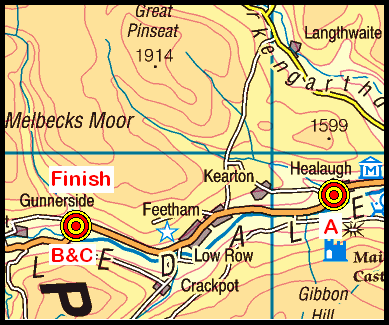
On Sunday, 19th July, the Stockton Rambling Club will have three walks in the Swaledale area of North Yorkshire. All walks will finish in Gunnerside {SD 951 982} - see the following map.
Crown Copyright (2009). All rights reserved. Licence No. 100046831. Produced using Anquet Maps.
The A-walk will start at Healaugh {SE 018 990} and will take in Arkle Town, Langthwaite, Great Punchard Gill and Old Gang Mines.
The B-walk will commence at Gunnerside {SD 951 982} and will take a circular route to visit Muker, Keld, Swinner Gill and Jingle Pot.
The C-walk will also take a circular route from Gunnerside and will pass through Thwaite, Muker and Oxnop Bridge.
This is a Route 2 coach pick up (Billingham: 9.30 am, Acklam: 9.45 am and Stockton: 10.00 am).
I have just written a 'second addendum' to John Fletcher's outstanding summary of Stockton Rambling Club's history. The First Addendum to John's work was added in December 2003 and outlined our uptake of modern digital technology - especially, (1) the use of computers and digital mapping systems for planning walks and (2) the growing use of personal GPS systems for navigation purposes.
In the Second Addendum to the record of the Club's history, I describe our use of 'social media' in the form of weblogs. Click this link to see the recently added Second Addendum.
As our Club Web site is now about ten years old, I have also recently updated some parts of it in an attempt to improve its consistency of appearance and remove some of the 'bugs' that I have found. Please continue to inform me of any errors that you come across.
The North-Yorkshire village of Rosedale Abbey is an excellent centre for walkers. From here it is possible to explore many different parts of the North Yorks Moors National Park. Today's expedition (5th July, 2009) took the form of a circular walk from the village - heading south to Lastingham (via High Askew) and returning via Ana Cross.
We set off from the village at about 10.54 am. There were 13 people in the group: Clive-G, Kath-H, Doreen-R, Joan-H, Jim-M, Pat-L, PB, Bryn-W, John-F, Margaret-B, Megan-H, Brian-H and Jan-S. PB led the walk.
From the village green we passed through the Parish Church of St Mary and St Laurence (see the picture below) and then headed in a westerly direction to reach a footbridge over the River Seven at {SE 721 959}. From here we had a gentle climb up through a meadow to meet the minor road at {SE 719 958} that runs in a south-westerly direction from Thorgill pass Sevenford House. Turning left, we followed this road to Red House Golf Course and onwards to a road junction at White Horse Farm Hotel/Inn {SE 724 955}.
At the road junction, we 'picked up' a public footpath that went in a south-westerly direction along a good farm track. Following this track down the valley, we passed by Newlands Farm and Hollins Farm {SE 733 944}. Our track continued in a SW direction - roughly following (on our left) the course of the River Seven. We had an early lunch stop in the shade of the trees at {SE 741 937} - just to the east of Cumratph Crag.
After lunch, we continued along our SW trek. As we approached Hartoft End (which was on the opposite side of the river), our path turned south and took us to High Askew {SE 744 913}. On this section of the walk we experienced heavy rain which necessitated the use of umbrellas and other water-proof equipment! Just after High Askew, we turned right and headed in a westerly direction towards the ford at Tranmire Beck {SE 740 907}. As we turned west off the track from High Askew, we encountered an impressive display of white and purple foxgloves.
After crossing the ford we entered a small wood at {SE 739 907} and then crossed a series of fields in order to get to the small village of Lastingham {SE 729 904}. We had a 20-minute stop here in order to explore the village and take in some of its history - particularly, that relating to Saint Cedd of Lastingham (see here for more details).
After our short stop in the village, we took an uphill road from the telephone box in a northerly direction. Passing the Lastingham Grange Hotel on our right, we passed through a wide gate onto Spaunton Moor. There were some wonderful displays of colourful heather to be seen here. We climbed gradually up onto Lastingham Ridge {SE 726 918} and continued our uphill climb to Ana Cross {SE 724 938} - almost the highest point of the walk. We took our short tea break here. Further details of this historic monument can be found by following this link.
From Ana Cross we had a gentle stroll across to the minor road at Bank Top (SE 722 948}. We crossed the road and continued on our northerly trek to reach the highest point on the walk at {SE 720 952} - there were some lovely views of Rosedale from here. We now turned right and commenced our rather steep descent towards Rosedale Abbey. As we lost height, we passed through Red House Golf course where we saw a beautiful display of Red-Hot Pokers and Petunia Surfinia (in a hanging basket).
We emerged from the golf course onto the minor road that we had previously walked along (Daleside Road) {SE 723 955}. From here, we took a straight, down-hill footpath to the road-bridge over the River Seven at {SE 724 957}. Turning left, we followed the road back to the coach, the village green and (for some) the Abbey Tea Room.
Overall, we had a great day. We were exposed to the extremes of weather conditions - both intense heat and torrential rain. Despite this, we experienced some really wonderful scenary. Use the buttons below to see where we went and some of the sights that we saw.
Addendum During my pre-walk check for today's expedition I had considerable difficulty finding one of the public footpaths that I wanted to use. I reported my difficulties to the North Yorks Moors National Park Authority. I now eagerly await news of what will be done to re-instate this path. A copy of my report can be found at this link.
During the week beginning Monday 13th July, Stockton Rambling Club will have THREE mid-week events available. The first is a day walk, the second is an evening walk and the third is a visit with an optional walk afterwards.
The first event is a day walk and will take place on Wednesday, 15th July. It will start at 10.30 am from the Ship Inn at Worsall {NZ 395 099} - see the map below.
This walk will be not be longer than 5 miles. Please ring 01642-780538 for more details.
The second event is an evening walk and will also take place on Wednesday, 15th July. It will start at 7.00 pm from the Devonport Hotel in Middleton One Row {NZ 351 123} - see the map below.
The length of this walk will be up to 6 miles. Please telephone 01325-469476 for more details.
The third event is a visit to the University of Durham Botanical Gardens and will take place on Thursday, 16th July. The cost of this event is £4.50. Please meet at 10.15 am at the Howlands Farm Park & Ride Station (PR2) {NZ 270 407} on the A177 - see the map below.
Following the tour of the gardens, there is an optional walk. The length of this walk will be up to 6 miles. Please telephone 01740-644347 for more details.
One of the problems of summer walking in shorts is the need to be alert to the possibility of picking up one or more ticks.
Quite recently, one of our members reported picking up six of these little creatures while doing his pre-walk check for the Rosedale Abbey A-walk. Subsequently, on the day he actually led his walk, he decided not to wear his shorts and put on his 'long trousers' instead.
There are various 'tales' of what to do in the event of picking up a tick. Having studied some of these, in my opinion, I think one of the best things to do is to carry a small tool (called a 'tick remover') in one's rucksack (see pictures below). These can be used to safely and easily remove a tick by strategically gripping it beneath its body and then 'unscrewing' it.
In relation to using the above tools, Martin-H said that a tick should always be unscrewed in an anticlockwise direction. However, the instructions that accompany the above devices do not suggest any particular preference for the direction of rotation. Apparently, either direction will do.
One important thing to remember when removing a tick: don't squeeze it since such an action could cause the 'injection' of its contents into the area of the body to which it is attached. Naturally, this could cause infection if the tick is itself carrying some form of disease.
DEET-based insect repellents are available commercially in a variety of different forms (such as sprays, creams, patches and wipes). These have been shown to be quite effective in preventing tick bites.
Case Study: I know of a keen walker who picked up a tick and because he really didn't know what it was, he did nothing about it. A short time later the tick dropped off - once it had had its fill of blood. However, by this time, the tick had infected him with Lyme Disease. The symptoms of this were redness near the infected area (a bullseye pattern), a rash, tiredness and an influenza-like condition. After seeking medical help, supported by the use of antibiotics, he eventually recovered and returned to normal health. The person involved in this case study was very fortunate in that he consulted a 'country' doctor who was familiar with the signs and symptoms of tick bites and Lyme Disease.
On Sunday, 12th July, the Stockton Rambling Club will have three walks in the Weardale area of County Durham. All walks will finish in Alston {NY 717 465} - see the following map. You can click on the map to see a larger, complete copy of the section shown below.
Crown Copyright (2009). All rights reserved. Licence No. 100046831. Produced using Anquet Maps.
The A-walk will start at Cowshill {NY 855 406} and will take in Allendale Common, Killhope Law and Nenthead.
The B-walk will commence at Nentsberry {NY 762 453} and will visit Wellhope Moor, Blakelaw Cross and Blagill.
The C-walk will set off from Nenthead {NY 781 437} and will pass through Ashgillside, Loaning Head and Low Crag.
This is a Route 3 coach pick up (Acklam: 9.30 am, Stockton: 9.45 am and Billingham: 10.00 am).
I was out at Rosedale Abbey {SE 724 959} on 23-06-2009 doing a pre-walk check for my then upcoming C-walk. I had great difficulty finding the path that I wanted to take out of Rosedale Abbey; so, I had to use an alternative route - see the annotated map below.
Crown Copyright (2009). All rights reserved. Licence No. 100046831. Produced using Memory-Map.
I had intended using Path 2 from Rosedale Abbey across to the minor road near Sevenford House {SE 7201 9569}. As can be seen from the map, the path should run parallel to, and just to the east of, a stream (and a boundary fence) that runs down hill to join the River Seven at {SE 7222 9586}. The path then merges with another footpath at {SE 7228 9590} - Path 1 in the above map.
Because I could not find the path I wanted to take, I decided to use Path 1 instead - for my outward trip. As it happened, I think this was a much more interesting route. After completing my pre-walk check, I returned to the village using Path 3. A full description of the day's walk can be found by following this link.
Searching for Path 29 On Tuesday 30th June it was a really lovely summer's evening. I therefore decided to drive over to Rosedale Abbey and have a look for Path 2. Officially, according to the North York Moors National Parks Authority, this is 'Rosedale Footpath 29'.
Following Path 1, I re-traced my earlier steps back to the minor road where Path 2 was deemed to start. There was no evidence to suggest an 'oficial' footpath entry into the field that should have hosted the footpath. On the contrary, where the FP should have started, there was a series of boards nailed in a horizontal position - as if to block something up (see the picture below).
I walked down the road a little further. About 25 metres after the entrance to Low Farm {SE 7206 9566}, I found a gate that enabled me to gain access to the field that I wanted to be in.
Once in the field I made my way to the location from where the path should have left the road. Using my GPS I followed the route of the path as it is defined in the Explorer OL 26 1:25000 map. Click here to see the GPS tracklog of where I roamed.
I followed the route of the path downhill to the point at which it should cross the River Seven. Here, I was confronted with a barbed-wire fence. As can be seen in the following picture, this would provide quite an obstacle to anyone who is not agile enough to cock his/her leg over the fence.
As I walked along the road towards Red House Golf Course, I got into conversation with a resident from Primrose Villas {SE 721 956}. We had an interesting chat about 'Footpath 29'. He told me that there used to be a 'green' public-footpath sign showing the entry to this path near Sevenford House/Hotel. So, where has it gone?
I returned to Rosedale Abbey a day or so later - armed with my wellington boots and walking poles. Wearing my 'wellies', I walked the length of the River Seven from the footbridge at {SE 721 959} down towards the road-bridge at {SE 724 958}. Sadly, I could not find any evidence for the existence of 'Footpath 29'.
Conclusion As a result of my field research, I could find no evidence whatsoever (other than on my maps) for the existence of Path 2 - alias 'Footpath 29'. There were no markers (in the form of yellow arrows), stiles or stepping stones across the beck. However, the crossing point probably corresponds to the place where the ford used to be - which would explain the absence of stepping stones.
Recommendation Action is needed to reinstate this path. So, what is needed? In my view each of the following issues need to be addressed:
a signpost with a yellow-arrow plate on it is needed on the village-side of the river;
a few stepping stones could be strategicaly positioned to facilitate river crossings;
a stile is needed to get over the fence on the western side of the river;
a stile is needed in the fence near Sevenford House/Hotel (to replace the 'boards' that currently exist there); and
a Public Footpath sign is needed on the road near Sevenford House.
Obviously, Item 4 in the above list could be obviated if the footpath is re-routed in order to use the gate (shown above) as the access point to the field containing the footpath.
The improvements identified above would add to the intrinsic attractiveness of the area both for visitors to the locality and for those who are involved in outdoor activities.
During the week beginning Monday, 6th July, Stockton Rambling Club will have TWO mid-week walks available. One is an evening walk and the other is a day walk.
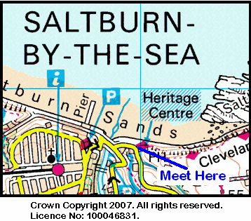
The evening walk is on Wednesday, 8th July and will start at 7.00 pm from the Ship Inn {NZ 669 215} in Saltburn-by-the-Sea - see the map and picture below.
This walk will be not be longer than 6 miles. Please ring 01642-715773 for more details.
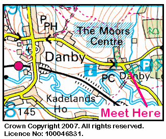
The day walk is on Thursday, 9th July. It will start at 10.30 am from the Moors Centre at Danby Lodge {NZ 716 084} - see the map and picture below.
The length of this walk will be up to 10 miles. Please telephone 01642-778247 for more details.
The North Pennines and Upper Teesdale are fantastic areas for walkers. It is therefore no surprise that these locations figure prominently in our walks programmes. Today's expedition (28-06-2009) took us from the B6277 road near Langdon Beck Youth Hostel {NY 860 304} (see the picture below) to the village of Dufton (in Cumbria) via Cauldron Snout and the Pennine Way.
We set off from our drop-off point near the Youth Hostel at about 11.15 am. There were 15 people in the group: Angela-W, Janet & Fred, Jill-L, John-P, John-S, Lorna-W, Mike-C, Monica-C, Pauline-B, Pauline-K, Phil-B, Phil-J, Shaun-G, and Wendy-F. Phil-B led the walk.
We headed in a south-westerly direction along a good track that passed New House Farm (on our right). We continued along this track to Saur Hill Bridge which we used to cross Harwood Beck at {NY 855 302}. Here, we joined the Pennine Way (PW) - whose route we were to follow (more or less) for the remainder of the walk.
From Sayer Hill {NY 853 303}, we followed the PW in a westerly direction to Widdy Bank Farm {NY 837 297}. We now had some excellent views of the River Tees as we followed its course upstream towards the very impressive Cauldron Snout waterfall {NY 815 286} (see the picture below). As we walked this section of the route, we had some superb views of Cronkley Fell (on our left) and Falcon Clints (on our right).
We had a good climb up from the relatively placid water near the confluence of the River Tees with Maize Beck - which comes into the Tees from the West. We climbed up the impressive rocks (see above picture) in the direction of Cow Green Dam which was built in order to hold back the water of the River Tees for domestic purposes. We had our lunch stop at the top of our climb - overlooking the waterfalls. Click this link to see a short video1 of Cauldron Snout. Be patient while it downloads!
From the cascading waterfalls, we followed the PW in a south-westerly direction to Birkdale and onwards to the footbridge that allowed us to cross Grain Beck {NY 801 277}. From here we continued on our SW bearing to Moss Shop {NY 796 273} - a ruined mine from bygone days. Passing by Rasp Hill on our right (the highest point on the walk), we arrived at the northern bank of Maize Beck {NY 775 268}. We followed the course of the beck in an upstream direction in order to get to the footbridge at Maizebeck Scar {NY 749 270}.
After spending a little time admiring the beautiful rock outcrops, we now moved in a SW direction across some rocky (but very flat) terrain in order to reach the next highlight of the walk: High Cup Nick {NY 745 262}. We really did have to 'tarry awhile' here in order to take in the impressive views of the scars - on either side of the valley. We had our tea break here, admiring the and watching High Cup Gill meandering away into the distance.
The 'Dufton Delights' button at the end of this posting will give access to the details of my previous expedition to this wonderful location - and the photographs that I took.
From High Cup Nick we made our way to Hannah's Well {NY 737 259} and then followed the PW to our final destination. This just involved a 'down-hill run' all the way to Dufton {NY 689 251} - see the picture below.
We set off from the Langdon Beck Youth Hostel in quite misty conditions; these stayed with us until we reached Maize Beck {NY 773 268}. The weather then seemed to improve remarkably as we made our way down to Dufton. Indeed, it got so hot as we made our descent pass Dodd Hill {NY 712 251} that a cool pint of shandy in The Stag Inn at Dufton was both a welcome and wonderful experience. Click this link to see the pub's Web site.
Overall, we had a great day. Use the buttons below in order to see where we went and how we did. You can also access related weblog postings.
Notes: 1Last summer I did a lovely video of Cauldron Snout using my digital camera (at 640 x 480). However, the file size of this clip is about 88 MB and takes 20-40 minutes to download - depending upon the Internet connection speed used. The short clip used in this posting was made during today's expedition and uses a smaller window size. It was produced using the 'compact video' mode setting on my camera. The resulting file size is under 2 MB and only takes a minute or two to download.