On Sunday, 6th September, the Stockton Rambling Club will have three walks in the Yorkshire Dales area of North Yorkshire. All walks will start in Masham {SE 225 807} and will finish in Middleham {SE 127 877} - see the following map.
Crown Copyright (2009). All rights reserved. Licence No. 100046831. Produced using Anquet Maps.
The A-walk will take in Gollinglith Foot, Red Way, Caldbergh and Hullo Bridge.
The B-walk will visit Low Ellington, Ellingstring, East Witton and Hullo Bridge.
The C-walk will pass through Low Ellington, Ramshaw and Jervaulx Abbey.
This is a Route 1 coach pick (Billingham: 9.30 am, Stockton: 9.45 am and Acklam: 10.00 am).
NOTE: The Acklam pick up will be at Croft Avenue opposite Cranford Gardens - due to the road race.
On Thursday, 3rd September, Stockton Rambling Club have a mid-week walk in the Preston-on-Tees area of Stockton. Please meet at 10.30 am at Preston Park - see the following map.
The walk will not be longer than 10 miles (C Pace). For further details ring 01642-882507.
Our SRC A-walk expedition today took us back again into the Weardale area of County Durham. Today's activity involved a trek from the village of Wolsingham {NZ 076 372} in a northerly direction, via Tunstall Reservoir and Smiddy Shaw Reservoir, in order to reach our final destination in the village of Edmundbyers {NZ 016 500}.
We set off from our drop-off point on the A689 (just to the east of the village centre - see the picture below) at about 10.45 am. There were 5 people in the group: JB, PB, RB, MC and JP. PB led the walk.
Leaving the A689 road, we followed Lydgate Lane from {NZ 080 372} in a northerly direction to meet the B6297 road at {NZ 079 378}. Turning right, we went uphill to {NZ 080 380} where we took another minor road on our left (Thistlewood Lane) in order to reach Thistlewood Farm {NZ 078 389}. From here we climbed up to the trig point on Wolsingham North Moor {NZ 077 404}. As we headed north, there were some good views of the radio masts at Rogerly High Plantation and Collier Law to the west. After passing the trig point, we stayed on the high ground for another 570 yards and then took a westerly down-hill path on our left that took us to the dam at the south-eastern end of Tunstall Reservoir {NZ 066 408}.
We crossed the dam and then followed a minor road along the western edge of the reservoir to arrive at a bridge at {NZ 069 418} near Tunstall House Farm. After crossing the bridge, we had a good climb in an easterly direction in order to get to the dismantled railway line at {NZ 078 420}. From here we took a north-westerly bearing and headed across Salter's Ridge and onwards to reach Drypry. By now, the rain had set in and we decided that it might be wise to take our lunch stop under the cover in the trees in the woods near to the disused quarries at {NZ 067 434}.
After a pleasant lunch stop under the trees, we continued our north-westerly trek along the edge of the forest - following the old Ministry of Defence boundary fence. We turned right at {NZ 053 443} and again at {NZ 053 446} and made our way across the fields to the dismantled railway line at Waskerley Farm {NZ 051 453}. From here we followed the Waskerley Way to a north-easterly track at {NZ 043 454}. We used this to navigate a route to Smiddy Shaw Reservoir {NZ 046 460} where we joined another track on our left. We used this track, and the dam wall itself, to 'half-circle' the reservoir in a clockwise direction to reach {NZ 044 464}. At this point we descended from the dam wall using a flight of steps.
From the reservoir we took a north-westerly bearing and headed for Lamb Shield Farm {NZ 024 489}. This involved trekking across Muggleswick Common and, in so doing, we had to cross both Hishope Burn {NZ 039 473} and Coalgate Burn {NZ 027 486}. Continuing on a westerly bearing, we crossed the B6278 road at {NZ 008 488} in order to pick up a track that took us down to a river-bridge at {NZ 004 490} near Swandale Cottage. We now took a track along Limerick Edge that went in a north-easterly direction up the western bank of Burnhope Burn in the direction of Edmundbyers. We joined the B6278 road at {NZ 013 497} and followed this to our final destination in Edmundbyers {NZ 016 500} - see the picture below.
Sadly, the local hostelry - the Punch Bowl - was closed for refurbishment. This meant that we could not get any refreshments at the end of our walks. Nevertheless, and despite the somewhat poor weather conditions, we had a great day.
Use the buttons below to see where we went, how we did and look at some the photos that we took.
On Monday, 31st August, Stockton Rambling Club have a mid-week walk in the Osmotherley area of the North York Moors. Please meet at 5.00 pm at the Queen Catherine pub in Osmotherley {SE 456 972} - see the following map.
The walk will not be longer than 6 miles. For further details ring 01642-715773.
On Sunday, 30th August, the Stockton Rambling Club will have three walks in the Western Region of the North York Moors. All walks will finish in Whitby {NZ 898 108} - see the following map. Note: click on the map in order to see a larger version.
Crown Copyright (2009). All rights reserved. Licence No. 100046831. Produced using Anquet Maps.
The A-walk will start at Egton {NZ 808 064} and will take in Littlebeck, New May Beck and Hawsker.
The B-walk will commence at Scaling Dam {NZ 744 128} and will visit Ugthorpe, Mickleby, Lythe and Sandsend.
The C-walk will set off from Egton {NZ 808 064} and will pass through Prior Farm, Grosmont Farm and Ruswarp.
This is a Route 1 coach pick up (Billingham: 9.30 am, Stockton: 9.45 am and Acklam: 10.00 am).
During the week beginning 24th August, Stockton Rambling Club will have TWO mid-week walks on offer. The first is an evening walk and the second is a day walk.
The evening walk will take place on Wednesday, 26th August. It will start at 7.00 pm from The Talpore public house near the Tees Barrage - see the map below.
This walk will be not be longer than 6 miles. Please ring 01642-880261 for more details.
The day walk will take place on Thursday, 27th August. It will start at 10.30 am from Scaling Dam East Car Park {NZ 755 128} - see the map below.
Crown Copyright (2009). All rights reserved. Licence No. 100046831. Produced using Anquet Maps.
The length of this walk will be up to 10 miles. Please telephone 01642-648682 for more details.
We often think of the North York Moors as our 'home territory' in relation to our walking activities. Today's B-walk took us through the heart of our homeland! Starting just south of Hawsker, we 'circled' in a clockwise direction to Biller Howe and then headed north to Littlebeck and Ugglebarnby and then finished in Sleights.
We set off on today's expedition at about 11.00 am. There were 13 people in the group: JBl, PB, PaB, MC, WF, JF. CL, JL, JM, MM, CR, ER and MW. PB led the walk.
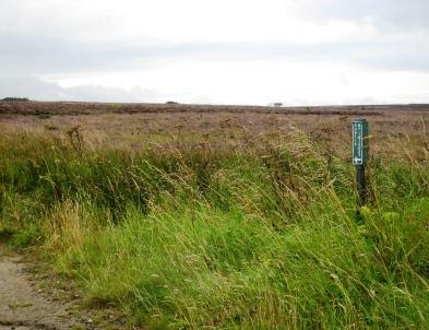
From the drop-off point on the A171 road {NZ 925 052} (see the picture below), we followed a good track in a south-easterly direction across the moorland to reach a minor road at Brow Top {NZ 930 046}.
As we walked south from the road were some good views of the sea and coastland surrounding Robin Hood’s Bay. At {NZ 932 044} we made a steep descent to Fyling Hall {NZ 937 043} and then ‘picked up’ a good farm track on our right. This took us up hill, in a south-westerly direction, through High Park Wood and along the northern edge of Oak Wood to reach Ramsdale Beck. We saw a wonderful example of a water-wheel at the old mill near Ramsdale Mill Farm {NZ 926 035}.
Now taking a southerly bearing, we skirted pass St Ives Farm {NZ 924 027} (on our right) and crossed a number of fields in order to reach a minor road at {NZ 929 018}. Turning right, we followed this in a south-westerly direction to cross the A171 road at {NZ 923 014} in order to reach Pond Farm {NZ 922 012}. We continued along the farm track for about 435 yards to {NZ 919 009}. At this point, we turned to a northerly bearing and went along Biller Howe Dale to reach Ling Hill Plantation {NZ 915 017} - where we took a westerly path. We used this in order to reach the eastern edge of Newton House Plantation {NZ 899 017}. Turning right, we now followed a northerly track (Robin Hood’s Bay Road) to arrive at John Cross {NZ 900 027} - see the following picture.
On leaving the locality of the old cross, we dropped down in a westerly direction to the car park at May Beck {NZ 892 024} where we stopped for an ice-cream. We then had a pleasant stroll through the woods to reach Midge Hall and Falling Foss {NZ 888 035}. This was followed by a gentle climb up to Newton Farm {NZ 0889 039}. We continued our up-hill trek in order to get to Newton House Lodge {NZ 890 042}. From here we took a path on our left that led us, via Thorn Hill {NZ 887 046}, to a minor road (Lousy Hill Lane) at {NZ 886 050}. Turning left, we then followed this road downhill towards Littlebeck.
Just before Littlebeck, at the road junction near the village hall {NZ 880 051}, we turned right and took the uphill road to reach a path on our left at {NZ 881 052}. We followed this in a north-westerly direction towards Busco Gill {NZ 877 059} where we had some difficulty finding the ‘official’ right-of-way1 across the gill. However, we did manage to find a waymarked stile in the fence after hacking our way through the gorse bushes using a pair of secateurs. Once we were into the wood, we made a steep descent to the gill (and the waymark that was located there) and an equally steep ascent up the north side to reach the waymarked stile through which we exited the wood.
After emerging from the wood, we made our way across the fields to a point {NZ 879 065} on a minor road just to the west of Dean Hall2 {NZ 883 064}. We then used Tom Bell Lane in order to get to a minor road at Low Farm {NZ 878 072} near to the small village of Ugglebarnby. As we approached the farm, there were some good views of the church up on the hillside to our right.
On reaching the road that runs from Ugglebarnby to Iburndale, we turned left and went downhill for about 200 yards to reach a public footpath on our right {NZ 877 073}. Just after taking this north-westerly path, I made a navigational error (see here for details). After recovering from this, we made a straightforward downhill trek to Iburndale Beck which we crossed using a footbridge at {NZ 870 077}. We followed the beck in a northerly direction to arrive at the railway station in Sleights {NZ 868 081}. This was just a stone’s throw away from the Salmon Leap Inn (see picture below) where our coach should have been waiting to take us home. Unfortunately, the pick-up location had been moved uphill to {NZ 867 079}!
We had another great expedition today. As JL would say: "It was an adventure"! Use the buttons below in order to see what we did, how we did and pictures of some of the wonderful sights that we saw.
Notes: 1Busco Gill Problem
During my pre-walk check for this expedition, I experienced great difficulty when trying to find the ‘official’ path across Busco Gill - as documented on the Ordnance Survey OL-27 map. Instead, I had to use a very muddy, gated cow-track further down the hill. There seemed to be a distinct lack of waymarks on the south-side of the gill and no stile (that I could find) in order to get over the boundary fence on the this side of the gill. By back-tracking from a North York Moors (NYM) marker at {NZ 878 061}, I did find what appeared to be a broken style on the north side of the gill. However, as I was to find out later, this was not the waymarked NYM stile. I reported my findings to the NYM Parks Authority on 14th August 2009.
2Path re-routing near Dean Hall
Since my 1993 Edition of OS Sheet 27, there has been considerable path re-routing in relation to the public right-of-way between Busco Gill and Tom Bell Lane. My latest 2008 Edition of Sheet 27 (and my Memory-Map 1:25000 scale digital maps) show the extent of the path diversions. The path from Busco Gill to Dean Hall (as shown on my 1:50000 scale 2002 Edition of Anquet digital maps for the area) no longer goes across the fields to Dean Hall. Instead, the path now goes directly north to Tom Bell Lane - as shown on the more up-to-date maps. Click this link in order to see a comparison of the old and new footpath arrangements.
On Sunday, 23rd August, the Stockton Rambling Club will have three walks in the Weardale area of County Durham. All walks will finish in Edmundbyers {NZ 017 500} - see the following map.
Crown Copyright (2009). All rights reserved. Licence No. 100046831. Produced using Anquet Maps.
The A-walk will start at Wolsingham {NZ 079 372} and will take in Slater's Ridge and Smiddy Shaw.
The B-walk will commence at Stanhope {NY 995 392} and will visit Rookhope, Sandyford and Pedham's Oak.
The C-walk will set off from near Stanhope (not shown on map) and will pass through Wilkinson's Cut and Old Man's Grave.
This is a Route 3 coach pick up (Acklam: 9.30 am, Stockton: 9.45 am and Billingham: 10.00 am).
Two Mid-Week Walking Events: Hartlepool and Hartburn
During the week beginning 17th August, Stockton Rambling Club will have TWO mid-week walks available. One is a day walk and the other is an evening walk.
The day walk is on Wednesday, 19th August and will start at 10.30 am from Hartlepool Headland - see the map below.
Crown Copyright (2009). All rights reserved. Licence No. 100046831. Produced using Anquet Maps.
This walk will be not be longer than 5 miles. Please ring 01642-533813 for more details.
The evening walk is also on Wednesday, 19th August. It will start at 7.00 pm from the old post office in Hartburn Village {NZ 428 178} - see the map below.
Crown Copyright (2009). All rights reserved. Licence No. 100046831. Produced using Anquet Maps.
The length of this walk will be up to 6 miles. Please telephone 01642-715773 for more details.
The village of Aysgarth {SE 004 884} is one of a number of delightful villages located in the North Yorkshire area of Wensleydale. It is probably most well known for its impressive waterfalls. Our expedition today took us north from Aysgarth Falls (see the photograph below) to Castle Bolton and then east to Leyburn via Lords Bridge and Middleham.
We set off from the A684 road (about 0.65 mile east of the centre of the village of Aysgarth) at about 11.15 am. There were 10 people in the group: JB, LB, PB, CH, MH, PJ, WM, JP, JY and PY. WM led the walk.
From near the vicarage on the A684 road {SE 013 883} we headed in a north-westerly direction, passing the impressive St Andrew's Church on our right as we went. We reached the River Ure {SE 011 886} and crossed over it using Yore Bridge. We paused for a few moments on the bridge to take in the view of the waterfalls - for which this area is so famous.
After crossing the river, we decided to introduce an amendment to the originally planned route. Instead of heading directly north to Caperby {SE 006 897}, we decided to go west via Bear Park {SE 007 890} and enter the village from the south west using the minor road that runs east from Askrigg.
From Caperby we headed north to {SE 001 902}} where we joined a north-easterly path that took us via Ponderledge Scar {SE 004 903}, Low Gate {SE 007 909} and the ford at Beldon Beck {SE 010 918} to Castle Bolton {SE 035 919}. We stopped here for a short lunch break on the village green. During our moments of rest, we had some magnificent views of the castle.
After a very pleasant lunch break, which included feeding the chickens that were roaming on the village green, we took a south-easterly bearing in order to reach Northgate Bridge {SE 042 909} - just south of the village of Redmire {SE 045 912}. We maintained our SE bearing to enter West Wood at {SE 059 901}. Our track through the wood took us to the front of the very impressive Bolton Hall {SE 074 896}. Turning onto a southerly bearing, we crossed the River Ure again - this time using Lords Bridge {SE 754 892}. Continuing our southerly trek, we crossed the A684 road (again) and followed Bay Bolton Avenue - passing Park Gate Farm {SE 075 884} on our left. After a climb up to {SE 076 880}, we turned east and made our way to Top Barn {SE 088 878}. We then had a refreshing tea stop (in the shade of the trees) at {SE 088 878} near Spigot Lodge Plantation.
From the tea-stop location, we navigated a south-easterly route in order to reach Naylor’s Hill {SE 096 874} and the trig point which lay further to the east of this on Cross Bank {SE 105 874}. Continuing our trek across Middleham Low Moor, we arrived at the village of Middleham {SE 126 877} - famous for, amongst other things, its castle. From here we took a north-westerly route in order to join the A6108 road at {SE 122 884}. We followed the road in a northerly direction to Middleham Bridge {SE 119 888} where we crossed the River Ure for the third time. As we approached Mighten’s Bank, we took a north-westerly footpath on our left at {SE 117 893}. This took us in a northerly direction (via The Cottage) to our final destination in Leyburn {SE 111 905}.
We had a great day today - wonderful scenery, good weather and tremendous company. We particularly enjoyed the deviation that was introduced - such events are always a hallmark of a good A-Walk! Many thanks to Bill for giving us such an interesting and enjoyable day. Use the buttons below to see where we went and how we did.
On Sunday, 16th August, the Stockton Rambling Club will have three walks in the Central Eastern area of the North York Moors. All walks will finish in Sleights {NZ 867 080} - see the following map.
Crown Copyright (2009). All rights reserved. Licence No. 100046831. Produced using Anquet Maps.
The A-walk will start at Cloughton {TA 009 946} and will take in part of the Cleveland Way, Raw and Sneatonthorpe.
The B-walk will commence near Hawsker {NZ 924 052} and will visit Ramsdale Mill, Biller Howe and Falling Foss.
The C-walk will set off from near the Flask Inn {NZ 930 008} and will pass through Biller Howe, Old May Beck and Falling Foss.
This is a Route 1 coach pick up (Billingham: 9.30 am, Stockton: 9.45 am and Acklam: 10.00 am).
Two Mid-Week Walking Events: Kirklevington and Pinchinthorpe
During the week beginning 10th August, Stockton Rambling Club will have TWO mid-week walks available. One is an evening walk and the other is a day walk.
The evening walk is on Wednesday, 12th August and will start at 7.00 pm from the Crown Hotel, Kirklevington {NZ 433 099} - see the map below.
Crown Copyright (2009). All rights reserved. Licence No. 100046831. Produced using Anquet Maps.
This walk will be not be longer than 6 miles. Please ring 01642-780538 for more details.
The day walk is on Thursday, 13th August. It will start at 10.30 am from Pinchinthorpe Visitor Centre {NZ 584 153} - see the map below.
The length of this walk will be up to 10 miles. Please telephone 01642-313138 for more details.
Today's expedition (2-08-2009) set off from the small village of Blubberhouses and went west via Beamsley Beacon to arrive at our ultimate destination in Ilkley. The first two of these locations brought back some vivid memories of good times spent participating in the Blubberhouses Moor 25 long-distance challenge walk (see the "Memories" button at the end of this posting).
We set off from Blubberhouses at about 11.15 am. There were 5 people in the group: PB, CH, JJ, JY and PY. JJ led the walk.
Initially, our trek took us in a north-westerly direction along the banks of the River Washburn towards Thruscross Reservoir. We crossed the dam and followed a minor road north to {SE 156 581} where we turned left and followed a permissive path around the reservoir. This took us to a minor road at {SE 137 583} near Duke's Hill. We walked along this road in a south-easterly direction to {SE 143 577} where we took a footpath on our right. We followed this in a southerly direction in order to reach Spittle Ings House {SE 137 568}. From here, we took a south-westerly bearing in order to reach Ramsgill Head and the A59 road near Kexgill Farm {SE 123 550}.
After crossing the A59 road we encountered our first (and only) major climb of the day. This took us up onto Round Hill {SE 121 536}. From here we followed the high ground in a south-westerly trek to reach Beamsley Beacon {SE 099 524} - see the picture below.
We descended from the beacon to meet a minor road/track near Beacon Hill House {SE 096 517}. Turning east, we made our way to Wards End {SE 105 518} where we changed our bearing to a south easterly one in order to cross Middleton Moor. This part of the walk took us through an area containing 'Cup and Ring' marked rocks.
After crossing the moor to reach {SE 114 505} we followed Park Lane in a southerly direction in order to reach Primrose Hill {SE 112 499}. We passed Myddleton Lodge {SE 111 491} on our right and then entered Coppy/Middleton Woods {SE 115 490} - emerging at {SE 118 487} on the outskirts of the town of Ilkley. Now heading south, we crossed the River Wharfe using the road bridge at {SE 117 480}. We continued for a short distance on our southerly bearing (along Brook Street - see picture below) in order to reach Ilkley Railway Station {SE 119 476} where our expedition finished.
We had a great day today. The weather was superb - as were the views we experienced. Many thanks to JJ for taking us on such a fantastic route. Use the buttons below to see where we went, how we did and photos of some of the scenary that we saw.
During today's walk I did something rather 'silly'! I tripped over a 'sleeping policeman' - click here for the full story!
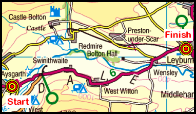
Sunday Walking in Wensleydale: Aysgarth to Leyburn
On Sunday, 9th August, the Stockton Rambling Club will have three walks in the Wensleydale area of North Yorkshire. All walks will finish in Leyburn {SE 011 883} - see the following map.
Crown Copyright (2009). All rights reserved. Licence No. 100046831. Produced using Anquet Maps.
All walks will start at Aysgarth Falls {SE 011 883}.
The A-walk will take in Castle Bolton, Lords Bridge and Middleham.
The B-walk will also visit Castle Bolton, Lords Bridge and Middleham.
The C-walk will follow the south bank of the River Ure to Middleham Bridge.
This is a Route 2 coach pick up (Billingham: 9.30 am, Acklam: 9.45 am and Stockton: 10.00 am).