Wednesday 30 September 2009

A-Walking: Alnwick Ambiences

Alnwick, Alnmouth and the surrounding coast are two of my favourite areas within eastern Northumberland. One of the outstanding features of Alnwick is its very impressive castle - see the photograph below1

Start of walk near Alnwick
Today's expedition involved visiting this outstanding part of the Northumberland coastal region. Our route started from Alnwick and took us to Embleton via Lesbury, Longhoughton, Craster and Newton Pool.

We set off from our starting point on the approach road to Alnwick {NU 195 118}, at about 10.50 am. There were 10 people in the group: PB, RB, KF, JG, CH, JJ, LM, MS, JY and PY. JJ led the walk.

From our drop-off point on the A1068 road we passed under the A1(T) dual carriage-way to find a good track at {NU 197 118}. We followed this in a north-easterly direction to a public footpath at {NU 199 119}. Turning right, we made our way along this in a south-easterly direction (passing East Cawledge Farm on our left) in order to cross Cawledge Burn using a footbridge at {NU 203 115}. In doing this, we had to traverse a wonderfully ‘atmospheric’ wooded valley. We emerged from the wood at {NU 204 115} and made a south-easterly trek to Bilton Banks {212 102}. We now took a north-easterly bearing and headed for the River Aln - passing by Greenrigg {NU 217 111} as we went.

We were thinking about crossing the river using the stepping stones at {NU 217 118}. However, because many of these were missing and the river was quite deep, we took an alternative route along the south bank to reach Bilton Mill {NU 221 120}, the railway viaduct at {NU 229 121} and then the A1068 road at {NU 233 115}. We crossed the road and then used the old bridge in Lesbury to cross the River Aln. Following the A1068 road in a northerly direction for about 0.5 mile, we went under the railway bridge and took a footpath on our right. As we went north we passed an interesting species of tree2 which we named ‘concretimus-plasticosum’ {NU 230 129}.

A new genus of tree
We continued our northerly trek to {NU 236 152} where we met a minor road. Turning left we followed this for about 100 yards and then took a north-easterly, becoming easterly, path towards Longhoughton where we joined the B1339 road at {NU 244 152}. Turning right, we headed in a southerly direction for about 100 yards and then turned left onto a minor road which took us to Low Stead {NU 253 156}. From here we made our way north to {NU 255 161} where we found a delightful path through the woods. This took us to the coast near Iron Scars where we had a well-overdue lunch stop at {NU 258 163}.

After lunch we followed the Northumberland Coast Path3 (NCP). With the sea on our right, we followed the NCP to Sea Houses {NU 261 173}, Cullernose Point {NU 260 188} and Craster {NU 258 200}. As we approached Craster, the aroma of smoked kippers became very apparent (see here).

Craster
We continued along the coast - passing the impressive Dunstanburgh Castle {NU 257 218} on our right. Just after the castle, the NCP turned onto a north-westerly bearing - taking us towards Embleton Bay and the Dunstanburgh Castle Golf Course. Passing the club-house on our left, we stayed with the NCP - continuing north across Embleton Links - in order to reach a westerly-going path at {NU 242 239}. Taking this, and passing Newton Pool Nature Reserve on our right, we climbed over Kelsoe Hill and continued in a south-westerly direction to meet the B1339 road at {NU 230 231}. Turning left, we now went south along the road into Embleton {NU 231 227} where the walk ended4 at the Dunstanburgh Castle Hotel - see the picture below.

Dunstanburgh Castle Hotel
Following our very pleasant ‘apres-promenade’ event in Embleton, we all boarded our coach and headed south for Alnwick where we picked up the members of the map reading class.

Use the buttons below to see where we went, how we did and some of the things we saw.


We had a great day today - combining both inland and coastal ambiences. Many thanks to Jill (and John) for facilitating the expedition.

Notes

1 I am extremely grateful to JG and JJ for providing this lovely photograph of Alnwick Castle and its reflection in a near-by lake.

2 The ‘tree’ that we saw was in fact a concrete pillar that supported various items of electronic communications equipment. In order to reduce its impact on the local ambience, it had been camouflaged with green coloured plastic branches. However, from a distance, it looked exactly like a pine tree!

3 The Northumberland Coast Path is a long-distance path (64 miles) that runs from Creswell {NZ 293 935} to Berwick-upon-Tweed {NT 994 534}. Some parts of this path coincide with the St Oswald’s Way long-distance path (97 miles) which runs from Holy Island {NU 136 417} to Heavenfield {NY 936 694}. Details of these walks can be found on the LDWA Web site (see here). The St Oswald’s Way path has its own Web site (see here).

4 We arrived at the end of our walk at about 4.15 pm - about one hour before the coach was due to depart. We therefore had plenty of time for our 'apres-promenade'.


Labels:

Sunday 27 September 2009

Club Weekend in Haworth - Sunday Walks

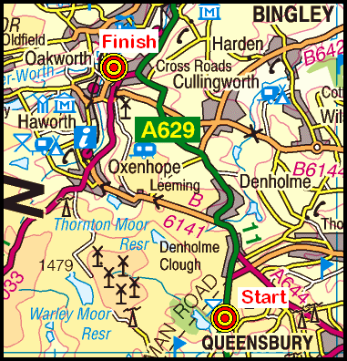
On Sunday, 4th October, each of the three walks will start at Ogden {SE 069 309} and will finish at Haworth Youth Hostel {SE 038 378} - see the following map.

Map of the Ogden-Haworth area
Crown Copyright (2009). All rights reserved. Licence No. 100046831.
Produced using Anquet Maps.

The A-walk will take in part of the Calderdale Way, High Brown Knoll, Top of Stairs and Shaw Lane.

The B-walk will visit Slaughter Gap, Rocking Stone Flat, Hambleton Lane and part of the Bronte Way.

The C-walk will go to Ovenden Moor and Hambleton Lane and will follow the Bronte Way to Oxenhope.


Labels:

Club Weekend - Haworth (Saturday walks)

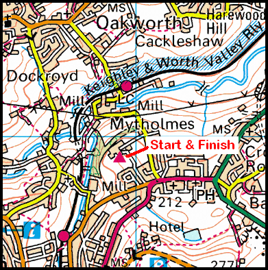
On Saturday, 3rd October, each of the three walks will follow circular routes starting from and finishing at the Youth Hostel {SE 038 378} - see the following map.

Map of the Mytholmes area
Crown Copyright (2009). All rights reserved. Licence No. 100046831.
Produced using Anquet Maps.

The A-walk will take in Penistone Hill, Bronte Bridge, Watersheddles Reservoir, Keighley Moor Reservoir and Newsholme.

The B-walk will visit Penistone Hill, Old Bess, Keighley Moor and Hare Hill.

The C-walk will go to Penistone Hill, Haworth Moor, Stanbury and Lord Lane.

Labels:

Saturday 26 September 2009

Club Weekend in Haworth - Travel Arrangements

The SRC weekend will take place on the weekend of the 2nd October. We will be staying in YHA Haworth {SE 038 378} in the Keighley area of North Yorkshire - see the following map.

Map of the Mytholmes area
Crown Copyright (2009). All rights reserved. Licence No. 100046831.
Produced using Anquet Maps.

The following photograph reflects the character of the Youth Hostel - alias Longlands Hall.
Photo of Longlands Hall (YHA Haworth)
Information on the facilities offered by Longlands Hall (YHA Haworth) can be found by following this link.

Travel to the Youth Hostel will involve a Route 1 coach pick up (Billingham: 6.15 pm, Stockton: 6.30 pm and Acklam: 6.45 pm).


Labels:

Tuesday 22 September 2009

C-Walking: Slapewath Solace

Our walks today were located in the eastern area of the North York Moors. They provided us with a pleasant combination of both coastal and inland walking. Today's C-Walk expedition took us from Loftus {NZ 715 184} to Skinningrove, along the coast to Saltburn and then inland to Slapewath via North Skelton.

We set off from Loftus Bank Top at about 10.35 am. There were sixteen people in the group. PB led the walk.

Loftus
From our drop-off point {NZ 715 184} (see the above picture) we headed north (towards the coast) along Deepdale Road. As we went, we passed Deepdale Pentecostal Church on our left and the Mars Inn on our right. After passing Loftus Leisure Centre (on our right) we followed a good track downhill to meet Skinningrove Beck on our left. We followed this into the village of Skinningrove where we joined the Cleveland Way (CW). Turning left, we followed this in a north-westerly direction pass the jetty and across the sand dunes at Cattersty Sands to reach {NZ 708 205} where we had our first climb of the day (about 130 feet) up onto Cattersty Cliff.

As we travelled north along the CW, we had some wonderful views of the sea and coastline on our right. To the left, Warsett Hill {NZ 692 214} figured prominently in the visual scene. As we reached the (now dis-used) site of the Huntcliff Ironstone Mine, we stopped briefly to explore the old fan-house. The mine was operational during the period 1872 through 1906 and employed a 'Guibal Fan' (see here) to ventilate the mine.

A little further along the CW, at {NZ 696 216}, we encountered some interesting examples of 'monumental' iron work1 - see the picture below (called 'Circle on Huntcliff')2. Because of the wonderful coastal views from this point, we decided to take our lunch stop here.

Iron-work Monument
After lunch we continued our trek along the CW, passing further examples of monumental iron-work as we went3. As we walked along the high-ground near Hunt Cliff we had some 'good' (?) views of the 'industryscape' that makes up industrial Teesside and Teesmouth. Just after we passed the Huntcliff Roman Signal Station {NZ 687 220}, we started to loose height as we made our gradual descent to the Ship Inn at Saltburn {NZ 670 216}.

After crossing Saltburn Road, we turned left and followed a footpath to Saltburn Gill - which was its characteristic 'yellow' colour. We followed the course of the beck (upstream) in a south-easterly direction to a bridge at {NZ 674 206}. We used this to cross the stream and then made our way in a north-westerly direction to emerge from the woods at {NZ 673 208}. Changing to a south-westerly bearing we made our way to a minor road (Saltburn Lane) at {NZ 670 207}. We followed this to (NZ 669 204} where we picked up a public footpath that took us to a round-about on the A174 road at {NZ 671 197} near Hagg Farm. We continued on a south-easterly trek (through an industrial estate near Wand Hills) to reach a footpath at {NZ 673 192}. We followed this downhill to {NZ 676 190} where we had a short tea-stop sitting in the glorious sunshine.

Continuing on our south-easterly bearing, we reached a minor road at {NZ 677 187} where we turned right in order to go to North Skelton. Just before the railway bridge, at {NZ 677 186}, we joined the Cleveland Street Trail. We now followed this in a south-westerly direction. After crossing Holme Beck, we made our way to White Cross Beck and Stanghow Road {NZ 668 182}. From here, we went across the fields - still maintaining our south-westerly bearing - passing Skelton Green on our right. After a short climb, we then reached Boosbeck Road {NZ 659 178}. Staying with the route of the Cleveland Street Trail, we continued onwards to Slapewath {NZ 642 158} where the walk terminated at the Fox and Hounds Inn (see the following picture).

Slapewath
Despite its variability during the week, the weather was very kind to us today. We experienced some wonderful sunshine which, combined with the tremendous coastal views, meant we had a really enjoyable expedition.

Use the buttons below to see where we went and some of the things that we saw.


Notes

1 As we walked up the Cleveland Way between Skinningrove and Saltburn we encountered some interesting examples of Richard Farrington's 'iron work' - see the second of the above three pictures. The date on this piece was 1996. This made me realise that it must be about 13 years since I last walked along this particular section of the CW - as this was the first time for me to see this (and the other 'iron works') in this area. The last time I was in this area (about a year ago) I led an A-Walk and we took a route that involved going over Warsett Hill - which would have meant that we would not have seen any of these interesting 'iron sculptures'.

2 Details on the sculptor (Richard Farrington) who created the metal sculptures on the Cleveland Way near Hunt Cliff can be found here. From the initial page select Public Art followed by Circle on Huntcliff.

3 The location of the other two metal sculptures is {NZ 692 217} - see Photographs 14 and 15 in the 'Photo Gallery' for this expedition.


Labels:

Monday 21 September 2009

Sunday Walking and Map Reading in Northumberland

On Sunday, 27th September, the Stockton Rambling Club will have four walks in the Alnwick area of Northumberland. All walks will finish in Embleton {NU 231 226} - see the following map.

Map of the Alnwick-Embleton area
Crown Copyright (2009). All rights reserved. Licence No. 100046831.
Produced using Anquet Maps.

The A-walk will start at Alnwick {NU 194 128} and will take in Lesbury, Longhouton, Craster and Newton Pool.

The B-walk will commence at Alnmouth {NU 247 107} and will visit Foxton Hall, Boulmer, Craster and Dunstanburgh.

The C-walk will set off from Boulmer {NU 265 143} and will pass through Sea Houses, Craster and Dunstanburgh castle.

The D-walk will involve a navigation course for novices (ring 01642-656273 for details).

This is a Route 3 coach pick up and is also an early start (Acklam: 9.00 am, Stockton: 9.15 am and Billingham: 9.30 am).


Labels:

Thursday 17 September 2009

Mid-Week Walking from Swainby

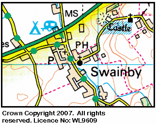
On Thursday, 24th September, Stockton Rambling Club have a mid-week walk in the Swainby area of the North York Moors. Please meet at 10.30 am in Swainby {NZ 476 021} - see the following map.

Map of the Swainby area
The walk will not be longer than 10 miles.
For further details ring 07892-908201.


Labels:

Wednesday 16 September 2009

A-Walking: Striding Strollers

Judging by the number of people we encountered today, Striding Edge must be one of the most visited areas of the north-east Lake District. Today's expedition took us on a circular route from Glenridding {NY 387 170} via Striding Edge, Helvellyn, Nethermost Pike, Dollywaggon Pike, Grisedale and Lanty's Tarn.

Prior to leaving the coach, our leaders had informed us (see here) that during our expedition we would pass by four ‘famous’ landmarks to events that had taken place in this area. We were therefore given the task of trying to locate these as the day’s walk progressed.

We set off from Glenridding at about 11.10 am. There were 10 people in the group: JB, PB, RB, JC, CH, MH, MalH, LM, SR and MS. MH and CH led the walk.

From our drop-off point in near the Ullswater Hotel, we located ourselves at Glenridding Bridge {NY 387 169} and from there we walked in a westerly direction along the southern bank of Glenridding Beck (see the picture below).

Leaving Glenridding
We followed the course of the beck until we reached Rattlebeck Bridge {NY 379 169}. From here we started the first (and hardest) climb of the day - a total ascent of 1800 feet! We climbed in a south-westerly direction (with Mires Beck on our right) up to {NY 372 161}. Now changing to a westerly bearing, we continued our climb up towards Birkhouse Moor. We completed our ascent at {NY 364 161} and now turned left onto a south-westerly bearing again. We maintained this bearing in order to reach Hole-in-the Wall {NY 359 155} where we stopped for a well-earned lunch break. The views from here were terrific.

After our lunch stop, we had our second climb of the day (about 500 feet). We continued on our south-westerly trek along Bleaberry Crag - passing Low Spying How on our left. Just after High Spying How, we came across the first ‘memorial’ which MH had requested us to find; this was located at {NY 349 149}. After passing this we continued in a westerly direction across Striding Edge {NY 347 149}. Because the weather conditions were so good, our crossing was a fantastic experience - with some tremendous views of Red Tarn on our right. It was surprising how many other people were also there to do Striding Edge and/or Swirral Edge (which lay a little further to the north-west). At some points during our traversal we had to ‘queue’ in order to get through some of the more precarious rocky areas.

Striding Edge
After crossing Striding Edge, we had our third major climb of the day (about 450 feet) up the rock face onto Helvellyn {NY 342 152}. On our way to the summit, we encountered the second and third of the memorials that we were to pass. After posing for a group photograph on Helvellyn we turned about and headed in a southerly direction to Nethermost Pike {NY 345 140}. After taking in the wonderful views, we continued on our southerly bearing and stopped near High Crag {NY 343 132} for a short tea stop.

After our short break, we climbed up onto Dollywaggon Pike {NY 346 131}. There were some really good views of The Tongue and Grisdale from here. Once we had taken in the views, we started our long and steep descent down to Grisdale Tarn {NY 350 123}. Just after passing the tarn we found the fourth memorial (“Brothers’ Parting Stone”) at {NY 352 123}.

Now heading in a northerly direction, we passed Ruthwaite Lodge (a climbing hut) at {NY 355 135} on our left as we made our way through Grisdale. Just after the hut, at {NY 357 137}, our path split into two. We took the one on our left that ran in a north-easterly direction along the northern side of Grisdale Beck. This path led us to Lanty’s Tarn {NY 383 162}. From here we descended down to Westside {NY 383 167} and then, at {NY 384 168}, we re-traced our steps back to Glenridding Bridge and then back to our coach which was waiting for us in the car park at the Ullswater Information Centre {NY 386 169} (see the picture below).

Ullswater Information Centre
We had a tremendous day today. The weather was brilliant, the views and scenery were magnificent and the company outstanding. Many thanks to MH and CH for ‘making it happen’!

During the course of the day I took 56 photographs and we accumulated over two hours of stop-time (much of this was taken up in admiring the awe-inspiring views). These figures reflect the outstanding nature of the sights we saw.

Use the buttons below to see where we went and some of the scenes we encountered.


Labels:

Monday 14 September 2009

Sunday Walking to Slapewath

On Sunday, 20th September, the Stockton Rambling Club will have three walks in the North-Eastern area of the North York Moors. All walks will finish in Slapewath {NZ 645 158} - see the following map. Note: click on the map in order to see a larger version.

Map of the Runswick Bay-Slapewath area
Crown Copyright (2009). All rights reserved. Licence No. 100046831.
Produced using Anquet Maps.

The A-walk will start at Runswick Bay {NZ 806 161} and will follow the Cleveland Way along the coast to Saltburn and then turn inland.

The B-walk will commence at Staithes {NZ 780 181} and will visit Roxby, Handale Liverton and North Skelton.

The C-walk will set off from Loftus {NZ 714 184} and will follow the Cleveland Way along the coast to Saltburn; it will then turn inland to Skelton Green and Cleveland Street.

This is a Route 1 coach pick up (Billingham: 9.30 am, Stockton: 9.45 am and Acklam: 10.00 am).


Labels:

Wednesday 9 September 2009

A-Walking: Middleham Mania

During the last few months, Middleham {SE 127 878} has figured prominently in a number of our walking expeditions.

In relation to today's expedition, this delightful village was the destination of our trek from Masham {SE 225 807} (see the picture below). Our route took us via Leighton, Gollinglith Foot, Colsterdale, Caldbergh Moor, Caldbergh and Braithwaite Hall.

Masham
We set off from Masham at about 11.00 am. There were nine people in the group: JB, PB, RB, CH, MH, JJ, PJ, LM and JP. PB led the walk.

We set off from our drop-off point on the A6108 road out of Masham {SE 222 809} in a westerly direction along Fearby Road. After about 140 yards, at {SE 221 809}, we turned onto a south-westerly bearing and headed for Westholme Road {SE 220 809} where we joined the route of the Ripon Rowel Walk. We followed this in a westerly direction across the fields to Micklebury Lane {SE 203 808} where we turned left. We went in a southerly direction down the lane for about 330 yards and then turned right at {SE 202 805} into Low Moor Lane. We continued our westerly trek in order to reach a minor road at {SE 187 804}. Turning left, we made a steep descent down the road (passing Swinton Saw Mill on our right) to reach a bridge at {SE 187 801}. We used this bridge to cross the River Burn.

From the bridge we followed the road and climbed in a southerly (becoming south-westerly) direction to Broadmires {SE 178 798}. We stopped here, very briefly, for a group photograph. We continued on our south-westerly trek until we reached {SE 168 793} where we now left the Ripon Rowel Walk. Turning onto a westerly bearing, we crossed Pott Beck (using an old stone bridge at {SE 166 793}) and then climbed up to the minor road at Leighton {SE 163 796}. Turning right, we followed this in a north-easterly direction (downhill) to Leighton Bridge {SE 166 800}. Just before the bridge we turned left onto another minor road that took us in a westerly direction to Crab House {SE 163 802}.

Continuing along this minor road we climbed up to the ‘Leeds Pals’ war memorial {SE 156 801}. We had a short ‘interest stop’ here - in order to explore the memorabilia that was located there. We continued our climb along the minor road to a road junction at {SE 151 800} where we turned right and started our descent down towards the River Burn. We left the road at {SE 151 803} and followed a public footpath in order to reach the footbridge over the river at Gollinglith Foot {SE 153 810}. We stopped here for a short lunch break.

After lunch we set off in a westerly direction along a minor road that was to take us to Colsterdale. As we went along this road there were some good views of the River Burn on our left. During our climb up to Colsterdale we also had some good views of Slipstone Crags, Brown Beck Crags and Agra Moor on our right. When we reached Colsterdale, we turned right at {SE 130 813} and followed a farm track in a northerly direction. We used this track in order to get up onto the access land near High Crags {SE 128 815}. From here we found quite a good path that followed the 310- and 330-metre contour lines which led us to a path at {SE 113 820}. This took us to a ford at Slip Wath {SE 106 824} which we used in order to cross Barnley Beck. After making our crossing we had a good climb which followed a line of grouse butts on our left. Just after the highest point on the walk (1317 feet), at {SE 101 828}, we joined a good track (Red Way) at {SE 100 830} and followed this downhill towards Caldbergh. We stopped at {SE 095 849} for a short tea break. From this vantage point we had some good views of Penhill (to the north-west) and Leyburn (to the north-north-east).

After a ‘chilly’ tea stop, we continued our descent towards Caldbergh. Just before Caldbergh Hall {SE 094 850}, we turned right and followed a good track in a north-easterly direction to {SE 104 855}. At this point we left the track to follow a footpath across the fields to a minor road at {SE 113 859}. Turning right, we followed this in an easterly direction to Braithwaite Hall {SE 118 859}. We now took a northerly path down to Hullo Bridge {SE 118 865} where we crossed the River Cover. Turning right, we followed the course of the river to {SE 127 867}. Here we turned onto a northerly bearing and climbed up onto William’s Hill {SE 127 873}. As we descended from the top of the hill there were some good views of Middleham Castle and our final destination in Middleham {SE 127 877}.

Middleham
Because we arrived at our destination a little earlier than expected, there was some time to partake of some light refreshments before boarding the coach to take us back home.

Use the buttons below to see where we went and how we did.


Labels:

Mid-Week Walking from Great Ayton

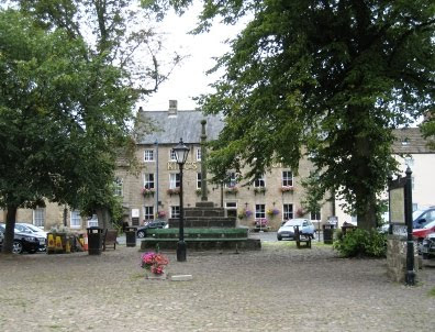
On Wednesday, 16th September, Stockton Rambling Club have a mid-week walk in the Great Ayton area of the North York Moors. Please meet at 10.30 am at the Royal Oak - see the following map and picture.

Map of the Great Ayton area
The Royal Oak Hotel, Great Ayton
The walk will not be longer than 5 miles - at a lesiurely pace.


Labels:

Monday 7 September 2009

Sunday Walking: Lakes Day - Patterdale Area

On Sunday, 13th September, the Stockton Rambling Club will have FOUR walks in the Patterdale area of the north-eastern Lake District. All walks will finish in Glenridding {NY 386 171} - see the following map.

Map of the Patterdale area
Crown Copyright (2009). All rights reserved. Licence No. 100046831.
Produced using Anquet Maps.

The A-walk will follow a circular route from Glenridding and will take in Striding Edge, Helvelyn and Grisedale. This expedition will involve a distance of 10.0 miles and a climb of 3300 feet.

The B-walk will commence at Patterdale {NY 394 161} and will visit Grisedale, St Sunday Crag and Lanty's Tarn. This trek will involve a distance of 9.0 miles and an ascent of 2700 feet.

The C-walk will set off from Glencoyne {NY 387 187} and will pass through Bleabank Side, Nick Head and Lanty's Tarn. This route will involve a distance of 7.0 miles and a climb of 1800 feet.

The D-walk will depart from Deepdale Bridge {NY 399 144} and will go to Brothers Water, Hartsop and Side Farm. This route will involve a distance of 7.0 miles and a climb of 600 feet.

This is a Route 2 coach pick up and is also an early start (Billingham: 8.30 am, Acklam: 8.45 am and Stockton: 9.00 am).

Note: This event must be pre-booked and costs £8-00.


Labels:

Wednesday 2 September 2009

Mid-Week Walking in Black Hambleton

On Thursday, 10th September, Stockton Rambling Club have a mid-week walk in the Western Region of the North York Moors. Please meet at 10.30 am at the Square Corner Car Park {SE 479 959} in Black Hambleton - see the following map.

Map of the Black Hambleton area
Crown Copyright (2009). All rights reserved. Licence No. 100046831.
Produced using Anquet Maps.

The walk will not be longer than 10 miles.
For further details ring 01642-314739.


Labels:

Tuesday 1 September 2009

A-Walking: Whitby Wanderers

Our expedition today took us into the eastern region of the North York Moors. Today's trek went from the small village of Egton {NZ 808 064} in an easterly direction via Littlebeck and New May Beck towards the village of Hawsker. We then headed in a northerly direction in order to reach our final destination in Whitby {NZ 893 113}.

We left from the Wheatsheaf Inn in Egton (see the picture below) at about 10.45 am. There were 7 people in the group: PB, RB, CH, LM, WM, JY and PY. PY and JY led the walk.

Egton
We set off in a southerly direction, heading downhill, towards School House Farm {NZ 809 060}. At this point we picked up a 'permissive path' on our left that took us down to the railway line near Beckside Farm {NZ 815 050}. Just after the farm we crossed the River Esk by means of a footbridge at {NZ 814 050} and then climbed up through Brow Wood to meet a minor road at {NZ 816 047}. We continued on a south-easterly bearing across some fields to reach another minor road at {NZ 818 045} on Lease Rigg. Turning left, and then right, we followed this road downhill into Esk Valley {NZ 822 043} where we turned left onto a good track. This took us in a north-easterly direction along the side of the North York Moors Railway (NYMR).

As we went along this track we were fortunate enough to see a steam locomotive leaving Grosmont in a southerly direction heading for Goathland. We followed our track pass the NYMR railway sheds and turned right at {NZ 827 050} to reach a church at {NZ 829 051}. We then took an interesting combination of paths through the woods that lay to the south-east of Grosmont railway station. These led us to a point about 260 yds on the hill above the railway level-crossing {NZ 830 052}.

We now had a goodly, extensive climb in an easterly direction along Fair Head Lane which took us up to the cattle grid near Lowther’s Crag {NZ 845 051}. Our climb involved an ascent of about 600 feet over a distance of just under a mile - with no flat bits! Taking a north-easterly bearing from the cattle grid (and still climbing!), we now picked our way through the moor-land heather on Black Brow in order to reach the A169 road at {NZ 862 048}. After crossing the road, we followed a good track in an easterly direction down into the small village of Littlebeck {NZ 879 049} where we had a very pleasant lunch stop on the grass just outside the Methodist church.

After lunch we headed south through Scarry Wood to reach The Hermitage {NZ 886 041} and Midge Hall {NZ 888 035}. Turning left, we now climbed up in a northerly direction towards Newton Farm {NZ 889 040} in order to find a path on our right. This took us in a south-easterly direction to a minor road at New May Beck {NZ 895 031}. Turning left, we followed this uphill to {NZ 897 034} where we turned right onto a footpath going in an easterly direction towards Hawsker. From {NZ 902 032} we took a north-easterly bearing and trekked across the moor to meet (and cross) the B1416 road at {NZ 908 040}. We continued on our NE trek across the moor (near Graystone Hills) until we reached {NZ 920 057} where we stopped for a short tea break. There were some good views of Whitby and Whitby Abbey from our vantage point.

From the tea-stop location, we headed north to Middle Rigg {NZ 917 062} and then followed Stainsacre Lane to Asp House {NZ 916 072} where we turned left and followed a minor road in a westerly bearing to reach The Riggs {NZ 912 072}. Turning onto a northerly bearing, we went along Long Rigg {NZ 910 077} in order to reach the disused railway track at {NZ 908 086}. We followed this track in a north-westerly direction (passing Larpool Hall Hotel {NZ 898 092} on our right) and crossed over the River Esk (again) - this time using the old railway viaduct at {NZ 896 097}. After crossing the viaduct, we made our way in a northerly direction to the West Cliff coach park in Whitby {NZ 893 113} where our coach was parked up waiting for us.

Whitby Abbey
We had a superb day today: we saw some tremendous and varied scenery and we had good weather for walking - we didn'tget any rain until after we were on the coach heading home. Many thanks to Paul and Julie for facilitating today's expedition.

Use the buttons below to see where we went and how we did.


Click this link to see some ''Pictures of the Sea at Whitby'.


Labels: