On Sunday, 3rd October, the Stockton Rambling Club will have three walks in the south-western area of the North York Moors. All walks will finish in Kepwick {SE 468 909} - see the following maps.
Crown Copyright (2010). All rights reserved. Licence No. 100046831. Produced using Anquet Maps.
The A-walk will start at Clay Bank {NZ 572 034} and will take in a section of the Cleveland Way, Scugdale, Sheepwash and Chequers.
The B-walk will commence at Chop Gate {SE 558 993} and will visit Arnsgill Ridge, Harker Gates and Thorodale.
The C-walk will set off from Sutton Bank {SE 515 831} and will take in a section of the Cleveland Way, Boltby, Kirby Knowle and Cowsby.
This is a Route 1 coach pick up (Billingham: 9.30 am, Stockton: 9.45 am and Acklam: 10.00 am).
On Thursday, 30th September, Stockton Rambling Club have a mid-week walk in the Greta Bridge area of North Yorkshire. Please meet at 10.30 am at the Morritt Arms Hotel {NZ 084 133} - see the following map.
Crown Copyright (2010). All rights reserved. Licence No. 100046831. Produced using Anquet Maps.
The walk will not be longer than 10 miles. For further details ring 01740-644347.
Our three expeditions this week (Sunday, 19th September) each took place in the Danby Dale and Esk Dale areas of the North York Moors. The A-Walk set off from Charltons, the B-Walk started at Brown Hill and the C-Walk commenced at Castleton. All three walks finished at Lealholm.
After leaving Charltons {NZ 645 157}, the intent of the A-Walk was to visit Brown Hill, Box Hall, High Castleton, Botton Village, Stonebeck Gate Farm and Crag Wood before arriving at our final destination in Lealholm {NZ 764 078}.
We left our drop-off point at about 10.20 am. There were four people in the group: PB, JH, CL and AM. JH led the walk.
We left our drop-off point near Charltons in quite heavy rain - as can be seen from the road-side puddles in the following picture.
We went along the A171 road in a south-easterly direction to reach the road junction at {NZ 647 155}. Turning left, we made our way along Margrove Road to a footpath on our right at {NZ 650 155}. We followed this in a southerly direction to re-join the A171 road near Aysdale Gate {NZ 651 148}. From here we climbed up onto Woodhill Gill Head and then joined the Quakers' Causeway on Stanghow Moor.
Following the Causeway in a southerly direction, we made our way to Brown Hill {NZ 670 117} and onwards over the moors to the minor road at Sand Hill {NZ 667 106} just above Commondale. We now descended across the fields in a southerly direction to join a good track at {NZ 667 101}. Turning left, we trekked along this track to Box Hall {NZ 677 090} where we turned right. After crossing the railway track and Commondale Beck, we climbed up the west side of the dale to reach Scale Foot {NZ 676 085} - where even the geese were sheltering from the rain!
After leaving the farm, we dropped down to the footbridge over the River Esk at {NZ 677 082} and then climbed up to High Castleton. From her we followed a public footpath at {NZ 683 078} that took us down-hill to Didderhowe Farm {NZ 685 075}.
Heading in a southerly direction, we made our way along Danby Dale to Holly Lodge Farm {NZ 685 064} where we stopped for a short lunch break. Fortunately, the rain held off during our stop and we had some good views of Castleton, Danby Church and Ainthorpe Rigg.
Continuing down the Dale, we reached Stormy Hall {NZ 688 044} where we turned left and descended along the road to the Weslyan church in Botton {NZ 692 044}. From here we had a good climb up through the village to the moorland road near Wolf Pitt {NZ 705 036}. Turning left along the moorland road, we headed off in a north-easterly direction to find a public footpath on our right at {NZ 710 044}. This took us downhill - passing Round Hill on our left {NZ 717 047} (see the following picture) - to reach another moorland road at Fairy Cross Plain {NZ 718 049}.
Turning left, we used the moorland road in order to make our way to Stonebeck Gate Farm {NZ 714 052}. On reaching the farm, we turned right onto a good track and followed this in a north-easterly direction towards Forester's Lodge {NZ 720 058}. Continuing on this bearing, we made our way towards Crag Farm {NZ 728 068}.
Just before reaching the farm, we turned onto an easterly bearing and navigated a route through Crag Wood - making our way to a farm track at {NZ 736 068}. After making a sharp U-turn, we now made our way to the minor road at {NZ 735 072} where we turned right onto an east-south-easterly bearing. Following the road to {NZ 738 071}, we turned left onto a footpath that took us in a northerly direction to the railway crossing at {NZ 740 076} and the minor road at {NZ 740 078} - just to the east of Houlsyke.
Turning right along the road, we continued on an east-south-easterly bearing to the public footpath at {NZ 74567 07705}. At this point we swung left onto an east-north-easterly bearing. Following the footpath across the fields, we passed High Park Farm {NZ 752 079} on our right and Park Wood {NZ 756 081} on our left. We then climbed up onto Elm Ridge to reach the path junction at {NZ 759 082}. Changing to a south-easterly bearing, we now followed a farm track to Lealholm railway station. After crossing the railway track, a downhill path led us into the centre of the village where our coach was waiting to take us home. By now, the weather had shown a remarkable improvement.
Many thanks to JH for organising such an interesting and exciting adventure for us today. We had a really great time - despite the inclement weather earlier in the day.
Use the buttons below to see where we went, how we did and some of the photos.
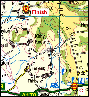
On Sunday, 26th September, the Stockton Rambling Club will have three walks in the Swaledale area of North Yorkshire. All walks will start and finish in Reeth {SE 038 993} - see the following map.
Crown Copyright (2010). All rights reserved. Licence No. 100046831. Produced using Anquet Maps.
The A-walk will take in Whaw, Little Punchard Gill, Doctor Gill and Surrender Bridge.
The B-walk will visit Fore Gill Gate, Great Pinseat, Surrender Bridge and Healaugh.
The C-walk will take in Arkle Beck, Arkle Town, Fore Gill and Healaugh.
This is a Route 2 coach pick up (Billingham: 9.30 am, Acklam: 9.45 am and Stockton: 10.00 am).
Late-September Mid-Week Visit and Walk (2010-09-23)
On Thursday, 23rd September, Stockton Rambling Club have a mid-week visit to the Tom Leonard Mining Museum in Skinningrove. The visit will be followed by an optional six-mile walk. The location of the museum is shown on the following map.
Crown Copyright (2010). All rights reserved. Licence No. 100046831. Produced using Anquet Maps.
The cost of the event is £4.00. For further details ring 01740-644347.
Our three expeditions this week (Sunday, 12th September) each took place in the Berwick-upon-Tweed district of Northumberland. All three walks started and finished at the small village of Belford.
After leaving Belford {NU 108 339}, the intent of the A-Walk was to visit Swinhoe Farm, Dancing Green Hill, St Cuthbert's Cave, Laverock Law, Shiellow Crags, Detchant and Craggyhall before arriving at our final destination.
We left our drop-off point at about 11.10 am. There were nine people in the group: JB, PB, RB, KF, CH, CL, AM, LM, JT. PB led the walk.
We left the centre of Belford (see the picture above) in a south-westerly direction along the B6349 road. At {NU 106 338} we turned right along a lane that took us in a north-westerly direction towards Westhall. We left the lane at {NU 104 339} by turning left onto a public footpath that took us across the fields to The Hagg {NU 094 343} and Weetside Crag {NU 087 348}. From here we descended to Swinhoe Farm {NU 084 350}.
We left the farm on a south-westerly bearing and made our way along a good track to Dick's Oldwalls {NU 076 345} and Kiln Wood {NU 071 342}. We entered a forest at {NU 070 342} and passed an old lime kiln on our right as we made our way towards the western tip of Colour Heugh {NU 064 337} - see the picture below.
Navigating a way through the undergrowth, we emerged from the forest using a gate at {NU 063 335}. We then climbed up to the cairn on the top of Dancing Green Hill {NU 064 333} in order to take in the view. After pausing for a few moments, we descended to the shelter of some impressive rock formations in order to take a short lunch stop.
Following our lunch break, we descended to the minor road at {NU 061 333} near Shop Hill. We then followed the road to {NU 056 332} where we turned right onto a track - the route of St Cuthbert's Way (SCW). We followed the route of SCW in a northerly direction towards Cockenheugh {NU 060 347} where we turned left onto a north-north-easterly bearing. Moving along the edge of the wood, we passed St Cuthbert's Cave {NU 059 352} on our right (see the picture below).
We stayed with the SCW until we reached some crags at {NU 059 354}. After taking in the view of the north-east coast towards Holy Island, we continued our trek on a north-north-westerly (NNW) bearing until we reached the trig point (OSBM S1616) on Greensheen Hill {NU 056 357}. From here we continued our NNW trek towards Holburn Lake {NU 049 363}.
From the gate in the wall near the lake, we navigated a route to the small village of Holburn {NU 041 361}. Just after passing through the village, we took a public footpath on our left and followed this in a westerly direction across the fields to reach Laverock Law {NU 031 362}.
We left Laverock Law on a NNW bearing to reach a minor road at {NU 028 368}. Turning right, we followed the road to a road junction at {NU 028 368} where we turned left. Now heading north, we continued along the road to {NU 038 374} to find a public footpath on our right.
Leaving the road, we turned onto a good track that took us in an easterly direction to Shiellow Crags {NU 052 376} where we stopped for a tea break.
Continuing along the forest track through Shiellow Wood, we crossed over the route of the SCW long-distance footpath at {NU 059 373}. After passing the impressive property at Shiellow Crag {NU 061 372}, we passed through Detchant Wood to arrive at a minor road near Park Wood Cottage {NU 082 373}.
Turning right along the road, we followed this in a southerly direction through Kettleburn {NU 084 368} and onwards towards Detchant {NU 086 365}. At the road junction in Detchant, we turned right and continued along the road for about 145 yards until we reached a farm access track on our left at {NU 08492 36438}. As we climbed in a southerly direction towards Henshopelaw {NU 085 354}, we had some excellent views of the north-east coast towards Holy Island.
Form Henshopelaw, we continued our southerly trek until we reached the minor road near Swinhoe Strip. Turning left, we followed the road for about 350 yards and exited from it at {NU 089 351} using a footpath that took us into Square Wood. At {NU 091 352} we turned onto a south-easterly bearing. Passing Sunnyside Crag on our left {NU 095 347}, we made our way to Craggyhall {NU 098 345}. Maintaining our south-easterly bearing, we had some good views of Chapel Crag as we made our way to Westhall {NU 103 340}.
From Westhall, we set a good pace in order to get to the tea-room in Belford for a cup-of-tea before boarding our couch for the trip back to Middlesbrough.
Overall, we had a very interesting and exciting expedition to Northumberland today. The weather was good and the scenary was out-standing.
Use the buttons below to see where we went, how we did and some of the photos.
On Sunday, 19th September, the Stockton Rambling Club will have three walks in the north-western area of the North York Moors. All walks will finish in Lealholm {NZ 763 078} - see the following map.
Crown Copyright (2010). All rights reserved. Licence No. 100046831. Produced using Anquet Maps.
The A-walk will start at Charltons {NZ 647 155} and will take in Sand Hill, Wolf Pit and Crag Wood.
The B-walk will commence at Brown Hill {NZ 670 117} and will visit Castleton, Blackmires and Danby Rigg.
The C-walk will set off from Castleton {NZ 688 081} and will pass through Danby Lodge, Danby Castle and Crag Wood.
This is a Route 1 coach pick up (Billingham: 9.30 am, Stockton: 9.45 am and Acklam: 10.00 am).
Our three expeditions this week (Sunday, 5th September) each took place in the Rosedale area of the North York Moors. The A-Walk set off from Brown Hill, the B-Walk started at Castleton and the C-Walk commenced at Castleton Rigg. All three walks finished at Rosedale Abbey.
After leaving Castleton {NZ 685 080}, the intent of the B-Walk was to visit Holly Lodge Farm, Stormy Hall, Honey Bee Nest, White Cross, Farndale Moor (dismantled railway line), Blakey Ridge and Thorgill before arriving at our final destination in Rosedale Abbey {SE 724 959}.
We left our drop-off point at about 10.40 am. There were sixteen people in the group. PB led the walk.
From our starting location in front of the primary school in Castleton, we followed a public footpath in a southerly direction to a path junction at {NZ 686 076}. Turning onto a south-westerly bearing, we passed by Didderhowe Farm {NZ 684 075} (on our right). We now navigated a route to the farm access track near Forest Farm {NZ 683 070}.
Continuing on our southerly trek through Danby Dale, we passed by Holly Lodge Farm {NZ 686 064} and Plum Tree Farm {NZ 689 054} in order to reach the minor road at Stormy Hall {NZ 688 044}. Maintaining our southerly bearing we made our way to Honey Bee Nest {NZ 688 034} where we turned onto a westerly bearing in order to start the major climb of the day.
Just after leaving Honey Bee Nest, we decided to stop for a short lunch break at {NZ 687 034} - in order to take advantage of the dry stone walls to shelter from the wind.
After our lunch break we continued our climb out of Danby Dale - making our way on a westerly bearing to a minor road at {NZ 682 029}. Turning left, a little further up the road we picked up a south-going track that took us over the moor to reach the minor road at {NZ 682 019} near White Cross.
After crossing the road, we followed a path in a south-westerly direction across the moorland that makes up Rosedale Head. This took us to the Castleton road at {NZ 675 012} near to the large boundary stone.
Continuing on our south-westerly bearing, we crossed the moorland terrain to reach the dismantled railway line on Farndale Moor at {NZ 656 005}. Turning left along the track, we followed this in a south-easterly direction to reach the road junction at {SE 683 989} on Blakey Ridge - just south of The Lion Inn.
From the car park near the road junction, we started our descent into Rosedale - stopping near {SE 689 988} (just above Moorlands Farm) for a very pleasant tea stop.
On leaving the tea stop location, we followed the farm track downhill to Moorlands Farm. Just after passing trough the farm, we turned right onto a good track (Daleside Road) at {SE 692 988}. This took us in a southerly direction along the west side of Rosedale to Thorgill {SE 707 966}.
Just after passing the cottages in Thorgill, we turned left onto a public footpath that took us downhill to a footbridge at {SE 710 967}. We used this to cross the stream and then turned back onto a southerly bearing. We now followed the track on the east side of the River Seven to reach Rosedale Abbey {SE 724 959}.
Although our walks today each started off from different locations, they showed a great deal of similarity in their latter stages. This meant that we were able to rendezvous successfully on the approach to, or at, Rosedale Abbey.
Use the buttons below to see where we went, how we did and some of the photos.
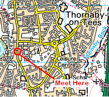
On Wednesday, 15th September, Stockton Rambling Club have a mid-week walk in the Thornaby area of Stockton-on-Tees. Please meet at 10.30 am at the Oddfellows Arms {NZ 451 162} on Thornaby Road (A1045) - see the following map.
Crown Copyright (2010). All rights reserved. Licence No. 100046831. Produced using Anquet Maps.
The walk will not be longer than 5 miles. For further details ring 01642-634255.
On Sunday, 12th September, the Stockton Rambling Club will have three circular walks in the Budle Bay area of Northumberland. All walks will start and finish in Belford {NU 108 338} - see the following map.
Crown Copyright (2010). All rights reserved. Licence No. 100046831. Produced using Anquet Maps.
The A-walk will take in Swinhoe Farm, Dancing Green Hill, Holburn, Laverock Law and Detchant.
The B-walk will visit St Cuthbert's Wood, East Holburn, Detchant and Craggyhall.
The C-walk will pass near Swinhoe Farm, Greenshot Hill, Upper Swinhoe Lake and Square Wood
This is a Route 3 coach pick up and is also an early start (Acklam: 9.00 am, Stockton: 9.15 am and Billingham: 9.30 am).
Our three expeditions this week (Sunday, 29th August) each took place in the Mallerstang/Eden Valley area of Cumbria. The A-Walk set off from Pendragon Castle, the B-Walk started at Aisgill Moor Cottages and the C-Walk commenced at Winton. All three walks finished at Ravenstonedale.
After leaving Pendragon Castle {NY 782 026}, the intent of the A-Walk was to visit Wild Boar Fell, Fox Hole, Rawthey Bridge and Green Bell before arriving at our final destination in Ravenstonedale {NY 723 040}.
We left our drop-off point at about 11.00 am. There were seven people in the group: PB, KF, CH, CL, AM, MS and JT. PB led the walk.
From our departure point near the road junction at Pendragon Castle {NY 782 026}, we circled around over Castle Bridge to the footpath at {NY 780 028}. With the River Eden on our left, we headed south along the Mallerstang valley to Shoregill {NY 780 014}. We continued our southerly trek until we reached the railway bridge near Turner Hay Hill {SD 778 995}.
From the railway track, we climbed on a westerly bearing to reach the gated wall at High Dolphinsty {NY 765 000}. At this point we turned onto a south-south-westerly bearing and continued climbing, via White Walls, up onto The Nab at the north-eastern edge of Wild Boar Fell {SD 763 991}.
Continuing along the high-ground of the fell, we headed on a south-westerly bearing to reach the trig point at {SD 758 987} and the cairns on the western edge {SD 752 982}. We had some tremendous views of Ravenstonedale Common from our vantage point at {SD 751 980}.
From the cairns on Wild Boar Fell, we descended in a southerly direction towards the stone wall at {SD 752 973}. Staying on the north side of the wall, we followed Uldale Gill in a westerly direction to Fox Hole {SD 740 972} [see Note 1] where we crossed the stream and climbed up out of the valley. We now followed a 'gated' route downhill to Needle House {SD 728 969}.
After passing the house we navigated our way across the fields in a north-westerly direction to reach the A683 road at Rawthey Bridge {SD 713 978}. From the road, we followed a footpath that took us in a westerly direction to a farm access track at {SD 705 977}. Turning right along this track, we climbed up to Narthwaite {SD 701 974} and continued uphill along a footpath that took us along the west side of Wandale Hill towards Mountain View {SD 699 987}
We stopped for a short tea break near a gated wall at {SD 701 983}. From here we had some good views of Yarlside and Kensgriff.
Continuing along our ascent path, we made our way on a northerly bearing to Spen Gill {SD 700 998}. We now had a steep climb in a north-north-westerly direction to reach a track at {NY 695 007} near Spengill Head. Turning right along this track, we completed the final ascent up to Green Bell {NY 698 010}.
From the trig point on the high ground at Green Bell we now made our way on a east-north-easterly bearing over Knoutberry {NY 704 013} and onwards to Ravenstonedale[see Note 2]. As we trekked through the village, we passed by The Black Swan Hotel[see Note 3] as we navigated our way towards the location where our coach was waiting.
Despite the strong 'head-on' winds that we encountered and,in many places, the water-laden ground under-foot, we had an interesting and exciting expedition today.
Use the buttons below to see where we went, how we did and some of the photos.
Notes
1 At Fox Hole we had to implement an error recovery strategy as a result of 'losing' AM and JT. The error situation arose as a consequence of the fact that they did not see us make a sharp descent from the high-ground at Fox Hole down to Uldale Gill. They therefore continued in a westerly direction down the north side of Needlehouse Gill while we were waiting for them on the south side.
2 At Green Bell, because we were running behind schedule, we decided not to do the route to Will Hill (as originally intended), but instead implemented my S2-Contingency route. This took us directly from Green Bell to Ravenstonedale. As this was a slightly shorter route, we were able to 'claw back' some of the time we lost at Needlehouse Gill. Despite this, we still arrived back in Ravenstonedale about 20 minutes late.
3 I spent two extremely pleasant days in Ravenstonedale earlier in the year during a photoshoot expedition. During my visit, I stayed at The Black Swan Hotel - which I can thoroghly recommend for its warmth and hospitality. They even had WiFi! It was great to revisit this wonderfully picturesque village during today's expedition.
On Thursday, 9th September, Stockton Rambling Club have a mid-week walk in the Bilsdale area of the North York Moors. Please meet at 10.30 am at the Clay Bank car park {NZ 572 035} - see the following map.
The walk will not be longer than 10 miles. For further details ring 01642-314739.


 of walk in Belford")