On Sunday, 5th September, the Stockton Rambling Club will have three walks in the Rosedale area of the North York Moors. All walks will finish in Rosedale Abbey {SE 724 959} - see the following map.
Crown Copyright (2010). All rights reserved. Licence No. 100046831. Produced using Anquet Maps.
The A-walk will start at Brown Hill {NZ 670 116} and will take in Castleton, White Cross, Lion Inn and Thorgill.
The B-walk will commence at Castleton {NZ 682 078} and will visit Danby Head, White Cross, Lion Inn and Thorgill.
The C-walk will set off from Castleton Rigg {NZ 682 028} and will pass through White Cross, Lion Inn and Thorgill.
This is a Route 1 coach pick up (Billingham: 9.30 am, Stockton: 9.45 am and Acklam: 10.00 am).
I had an interesting experience during a recent trip to Belford in Northumberland - in order to check out the SRC A-walk for the 12th September.
The incident happened in the forest near Colour Heugh while I was trying to find the path to Dancing Green Hill - see the following map.
Crown Copyright (2010). All rights reserved. Licence No. 100046831. Produced using Memory-Map.
As can be seen from the GPS trace of my route (the red line in the above diagram), I was zig-zagging through the forest, fighting the undergrowth and fallen-down trees, when suddenly I felt a tug on my GPS lanyard. At the time, I thought no more of it. However, about 30 yards further on, I looked down to see that my GPS was no longer with me!
How could I go on with out my GPS, I thought?
While I could easily navigate with my map and compass, how would I know where to take my photographs and how would I record the exact locations where I actually took them?
So, bearing in mind the urgency of the situation, I undertook a logistic search process in the immediate forest area through which I had just come - sometimes on my hands and knees, patting the ground with my hands. Suddenly, after about 20 minutes of searching, I saw my yellow Garmin eTrex GPS lying in the undergrowth ahead of me. I was at last re-united with it!
Undoubtedly, it was the systematic search process of the forest area that saved the day.
When my excitement had calmed a little, I did a post-recovery analysis of the incident and deduced that during my battle with the undergrowth, the GPS had got caught in some low-lying tree branches. Subsequently, (not noticing this), as I walked on it got yanked from the lanyard as a result of the failure of a small plastic lug on the connector that links the GPS to the lanyard.
It's just as well that, on the particular day of the Belford adventure, I was using my 'yellow' GPS as opposed to my 'black' one - which I normally use. Had I been using the latter, it would have been very unlikely that I would have found it within the dark-coloured undergrowth that I had been searching through.
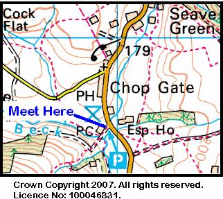
Our three expeditions this week (Sunday, 22nd August) each took place in the Bilsdale area of the North York Moors. The A-Walk set off from Newgate Bank car park, the B-Walk also started from here while the C-Walk took the form of a circular walk. All three walks finished at Chop Gate.
After leaving Newgate Bank {SE 564 888}, the intent of the A-Walk was to visit Old Fold, Stork House, Ankness, Stump Cross and Tripsdale before arriving at our final destination in Chop Gate {SE 558 993}.
We left our drop-off point at about 10.45 am. There were ten people in the group: JB, PB, KF, CH, JH, CL, LM, WR, MS, JT. As a new member, WR was welcomed to the group. JH led the walk.
We left the B1257 road at {SE 564 888} on a north-easterly bearing and followed a good track that took us along the western edge of the high-ground on Rievaulx Moor. The extensive coverage of colourful heather on the more provided a very picturesque setting for our trek - see the picture below.
We passed by Ayton Bank {SE 573 902} on our left and continued along the moor-land track until we reached the footpath at Rievaulx Bank {SE 582 905}. At this point we descended to the lower ground near Roppa Wood {SE 586 908}. Continuing along a good forest track in an easterly direction, we made our way to an isolated forest cottage (Old Fold) at {SE 604 905} - see the following picture.
Now moving in a south-easterly direction we progressed along our route to reach the minor road at {SE 609 902} where we turned onto a north-easterly bearing that took us to Lund Farm {SE 612 904}. After passing through Throstle Nest {SE 616 906}, we headed north towards a gated fence at {SE 618 913}. We now returned to our north-easterly bearing as we went along a moor-land footpath to arrive at a well-defined track (Little Roll Gate) {SE 625 920} on Hagg Common. Turning left, we followed the track in a north-westerly direction to reach a track junction at {SE 618 933} near an old disused pit. Changing back to a north-easterly bearing, we now made our way to Stork House {SE 622 944} (see below) where we stopped for a short lunch break.
After our very restful lunch stop, we descended into Low Wood and crossed Hodge Beck using the footbridge at {SE 626 944} near the weir. From here we climbed up onto Ankness Ridge to the path junction at {SE 636 939}. At this point we turned left and made our way along the farm access track to reach Bransdale Road at {SE 637 944}. We now followed the road in a northerly direction to reach Spout House {SE 626 970}.
Leaving the road at {SE 625 969}, we navigated a route across Bransdale in order to reach the minor road near Colt House Farm {SE 616 974} - see the picture below.
After a short climb up to a spot near the minor road above the farm {SE 614 975}, we stopped for a brief tea break. From the location at which we sat, there were some good views of Bransdale both to our left and to our right.
Following our brief stop, we had a good climb up the bank in a north-westerly direction to reach Stump Cross {SE 606 981}. Once we were on the high-ground, we experienced some refreshing, cool breezes as we trekked in a westerly direction across Slape Wath Moor to reach the peaceful valley of Tripsdale {SE 582 988}.
After crossing Tripsdale Beck, we had another good climb up onto Nab End Moor {SE 574 992}. From here we had an easy descent over Black Intake to reach William Blake Farm {SE 569 994}. Continuing our descent along the access track to the farm, we arrived at the B1257 road near the Village Hall at Chop Gate {SE 559 993}.
Our coach was waiting for us in the car park. However, before leaving on the ‘home run’, we were able to take part in a ‘tea and scones’ event that had been organised for us by VC.
Many thanks to JH for organising such an interesting and exciting adventure for us today. We had a really great time. We are also very grateful to VC for arranging the tea and scones - very many thanks.
Use the buttons below to see where we went, how we did and some of the photos.
On Thursday, 2nd September, Stockton Rambling Club have a mid-week walk in the Bilsdale area of the North York Moors. Please meet at 10.30 am at the Chop Gate car park {SE 559 993} - see the following map.
The walk will not be longer than 10 miles. For further details ring 01642-805781.
On Monday, 30th August, Stockton Rambling Club have a mid-week walk in the Guisborough area of the North York Moors. Please meet at 5.00 pm at the Cross Keys Inn on the A171 road to Guisborough {NZ 567 158} - see the following map.
The walk will not be longer than 6 miles. For further details ring 01642-715773.
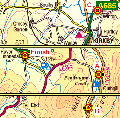
On Sunday, 29th August, the Stockton Rambling Club will have three walks in the Mallerstang area of the North Yorkshire Dales. All walks will finish in Ravenstonedale {NY 722 042} - see the following map.
Crown Copyright (2010). All rights reserved. Licence No. 100046831. Produced using Anquet Maps.
The A-walk will start at Pendragon Castle {NY 782 026} and will take in Shoregill, Wild Boar Fell, Needle House, Narthwaite and Green Bell.
The B-walk will commence at Aisgill {SD 774 976} and will visit Swarth Fell, Wild Boar Fell and and Crooks Beck.
The C-walk will set off from the Winton {NY 784 105} and will pass through Smardale Mill and Smardale Gill (nature reserve).
This is a Route 2 coach pick up and is also an early start (Billingham: 9.00 am, Acklam: 9.15 am and Stockton: 9.30 am).
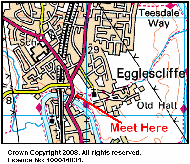
During the week beginning 23rd August, Stockton Rambling Club will have TWO mid-week walks available. One is an evening walk and the other is a day walk.
The evening walk is on Wednesday, 25th August and will start at 7.00 pm from the Blue Bell Inn, Eaglescliffe, near Yarm Bridge - see the map below.
This walk will be not be longer than 6 miles. Please ring 01642-880261 for more details.
The day walk is on Thursday, 26th August. It will start at 10.30 am from Stokesley Town Hall {NZ 525 086} - see the map below.
The length of this walk will be up to 10 miles. Please telephone 07892-908201 for more details.
Our three expeditions this week (Sunday, 15th August) each took place in the Hexham area of Northumberland. The A-Walk set off from Hexham, the B-Walk started at Bardon Mill and the C-Walk commenced at Haydon Bridge. All three walks finished at Bardon Mill.
After leaving Hexham {NY 937 641}, the intent of the A-Walk was to visit Hole House, Dipton Mill, Rebel Hill, Stawardpeel Wood, Plankey MIll and Shaws before arriving at our final destination in Bardon Mill {NY 778 646}.
We left our drop-off point at about 11.15 am. There were nine people in the group: JB, PB, RB, KF, JH, CL, AM, LM, JT. PB led the walk.
From the car park near the swimming pool and sports centre {NY 938 641} we walked in a westerly direction towards Hexham Abbey and market place - see the picture below.
Turning left at the market place, we made our way in a southerly direction to Eastgate {NY 936 639} and then followed a narrow walled footpath to {NY 936 632} where we joined a minor road. We followed this uphill to {NY 935 629} and then took a footpath on our left. We followed this uphill in a southerly direction to the minor road near the reservoir at {NY 935 623}. Continuing along the path and maintaining our southerly bearing we arrived at Hole House {NY 934 611}.
Now turning to the right, we followed the footpath in a westerly direction to Dipton Mill {NY 929 610}. Keeping West Dipton Burn on our left, we made our way through West Dipton Wood to reach the minor road at {NY 88524 61697} near Nubbock Lodge Wood. Staying on the road, we made our way in a southerly direction to West Greenridge {NY 884 608} where we turned onto a south-south-westerly bearing in order to reach the path junction at {NY 880 597}. At this point we turned onto a westerly bearing and trekked across Greenrigg Moor to reach Rebel Hill {NY 846 595}, Brownley Hill {NY 838 591} and Round Meadows Farm {NY 828 591}.
Leaving the farm on a roughly westerly bearing, we now had to trek along minor roads to reach the A686 near the old Staward railway station {NY 806 596} - now a private residence. From here we followed a northerly public footpath to Gingle Pot {NY 805 601}. We descended towards Stawardpeel Wood and entered it at {NY 803 604}. As we went through the wood, we often had some spectacular views of the River Allen on our left.
We navigated a northerly route through the wood to emerge near Plankey Mill {NY 796 621} where we used a footbridge to cross the River Allen.
From the bridge, we now had a good climb up through Briarwood Banks to reach the farm and the minor road (Ward Way) that lay beyond it at {NY 789 625}. Turning left along the road, we continued along it for about 390 yards and then turned right onto a public footpath at {NY 785 624}. Following this in a northerly direction, we made our way to Wool House {NY 785 631} and Shaws {NY 782 634}.
From Shaws, we continued our northerly trek to the footbridge that took us over the River Tyne at {NY 781 643}. We next crossed the railway line at {NY 781 644} and continued to the road junction near Mill House Farm {NY 781 645}. Turning left at the road junction, we then made our way to the pottery (see below) in the centre of Bardon Mill {NY 778 646}.
Despite the intense heat we experienced during the day, the wonderful views that we were exposed to inspired elements of joy and happiness as we took in the Northumberland landscape during our hike from Hexham to Bardon Mill.
Use the buttons below to see where we went, how we did and some of the photos.
On Sunday, 22nd August, the Stockton Rambling Club will have three walks in the western region of the North York Moors. All walks will finish in Chop Gate {SE 559 993} - see the following map.
Crown Copyright (2010). All rights reserved. Licence No. 100046831. Produced using Anquet Maps.
The A-walk will start at Newgate Bank {SE 564 888} and will take in Ankness Ridge, Spout House and Tripsdale.
The B-walk will commence at Newgate Bank and will visit Hawnby, Cow Wath and Arnsgill Ridge.
The C-walk will set off from Chop Gate {SE 559 993} and will follow a circular route that passes through Three Howes, Hasty Bank, Clay Bank and Urra.
This is a Route 1 coach pick up (Billingham: 9.30 am, Stockton: 9.45 am and Acklam: 10.00 am). Note: after the walks, tea and scones will be available in the Village Hall at Chop Gate.
Our three expeditions this week (Sunday, 8th August) each took place in the Upper Wharfedale area of North Yorkshire. The A-Walk set off from Buckden, the B-Walk started at Starbotton and the C-Walk commenced at Kettlewell. All three walks finished at Buckden.
After leaving Starbotton {SD 952 748}, the intent of the B-Walk was to visit Starbotton Fell, Buckden Pike, Cow Close, Cray, Yockenthwaite and Hubberholme before arriving at our final destination in Buckden {SD 941 772}.
We left our drop-off point at about 11.15 am. There were eleven people in the group: AB, PB, MC-1, MC-2, KF, WF, FH, JH, MaH, MeH and SS. MC-1 and MC-2 led the walk.
We set off in an easterly direction along the narrow road that passes along the side of the Fox and Hounds hostelry in Starbotton - the road going to the left in the picture below.
Almost immediately after passing the inn, we turned left and crossed a road bridge that took us over Cam Gill Beck. After an initial zig-zagging uphill, we climbed in a northerly direction to the footpath junction at {SD 953 753}. Taking the path on our right, we continued to climb in a north-north-easterly direction to reach Walden Road {SD 956 765}. Now changing to a north-easterly bearing, we continued our uphill trek to reach Starbotton Fell.
Using the boundary wall at {SD 965 776} as a shelter from the wind, we stopped for a short lunch break. From here, we continued to climb - uphill over the peat hags - until we reached the Memorial Cross {SD 962 778} at the southern-most tip of Buckden Pike.
Heading north along the high ground, we continued our trek to the trig point at the northern end of Buckden Pike {SD 960 787}. At this point I wandered off (with the leaders' permission) to take a photograph in a nearby neighbouring grid-square.
We descended from the high ground in a westerly direction to Cow Close {SD 947 788}. A further height reduction took us down to Buckden Rake {SD 941 784}. Then, following the course of the public footpath, we navigated a route to the minor road (Park Lane) at Cray {SD 94220 79217}.
Continuing in a westerly direction, we followed the public footpath in a westerly direction to Crook Gill {SD 934 791}. Just after the footbridge we stopped at a convenient outcrop of rocks for a short tea break near Hubberholme Wood {SD 924 787}.
We continued our westerly trek to Scar House {SD 921 789} and the footbridge that lay beyond it at {SD 916 787}. Just after passing Little House {SD 910 789} we started our rocky descent down to Yockenthwaite {SD 905 791} - where we did a 'U-turn' in order to follow the route of the Dales Way.
We followed the Dales Way along the northern bank of the River Wharfe towards Hubberholme {SD 926 782}. Using the road bridge at Hubberholme, we crossed the River Wharfe and, turning left, followed the minor road (Dubb's Lane) to {SD 93225 77960}. At this point we turned left, leaving the road, and followed the public footpath (and the Dales Way) in a south-easterly direction to Buckden {SD 941 772} - see the picture below.
Many thanks to Malcolm and Marjorie for organising such an interesting and exciting adventure for us today. I think we all had a really wonderful time exploring the blissful beauty of the Buckden area of Upper Wharfedale. Of course, we are also grateful to you for changing the route of the walk in order to minimise the extent of the bogs that we had to negotiate.
Use the buttons below to see where we went, how we did and some of the sights we saw.
During the week beginning 16th August, Stockton Rambling Club will have THREE mid-week events available. The first is a day walk, the second is an evening walk and the third is a guided tour and 'much, much more'!
The first event is a day walk and will take place on Wednesday, 18th August. It will start at 10.00 am from Yarm station - see the map below.
This walk will be not be longer than 5 miles. Please ring 01642-780538 for more details.
The second event is an evening walk and will also take place on Wednesday, 16th August. It will start at 7.00 pm from the King's Head at Hutton Rudby - see the map below.
No distance given. Please telephone 01642-786637 for more details.
The third event is a guided tour of Thorp Perrow Arboretum and will take place on Thursday, 19th August. The cost of this event is £7.00. More details are available by telephone from 01740-644347 for more details.
On Sunday, 15th August, the Stockton Rambling Club will have three walks in the Hexham area of Northumberland. All walks will finish in Bardon Mill {NY 777 646} - see the following map.
Crown Copyright (2010). All rights reserved. Licence No. 100046831. Produced using Anquet Maps.
The A-walk will start at Hexham {NY 937 648} and will take in Dipton Mill, Rebel Hill, Stawardpeel Wood, Plankey Mill and Wool House.
The B-walk will commence at Bardon Mill {NY 777 646} and will follow a circular route that takes in Housesteads, Roman Wall and Cranberry Brow.
The C-walk will set off from Haydon Bridge{NY 841 644} and will pass through West Morwood and Vindolanda.
This is a Route 3 coach pick up (Acklam: 9.30 am, Stockton: 9.45 am and Billingham: 10.00 am).
Our three expeditions this week (Sunday, 1st August) each took place in the eastern coastal region of the North York Moors. All the walks set off from Loftus and finished at Staithes.
After leaving Loftus {NZ 722 181}, the intent of the A-Walk was to visit Handale, High Waupley, Waupley Moor, Beacon Hill, Scaling Reservoir, Newton Mulgrave and Hinderwell before arriving at our final destination in Staithes {NZ 781 185}.
There were ten people in the group: JB, JPB, PB, KF, JH, CL, KL, BM, LM and JT. JB led the walk.
We left Loftus at about 10.40 am - see the clocks in the picture below.
Heading in a southerly direction we made our way across some pleasant countryside to reach Handale {NZ 726 156} and then, further south, High Waupley {NZ 727 144}. Just after Low Waupley {NZ 725 135} we crossed Waupley Moor to reach the A171 road at {NZ 731 125}.
We stopped for a short lunch break at {NZ 731 124} and then continued our moorland trek in a southerly direction to reach Beacon Hill and Danby Beacon {NZ 736 092}.
From the Beacon, we headed back across the rough moorland terrain on Easington High Moor towards Scaling Reservoir. After we joined the public footpath at {NZ 743 120}, we lost three of our group. Some people went in an anticlockwise direction around the reservoir while the three people at the back of the group went in a clockwise direction - primarily because they did not know in which direction the leader had gone in!
We re-assembled at the East Car Park at Scaling Reservoir {NZ 755 128}. Because of the time lost as a result of losing some of our group, our walk had to be cut short. Instead of going to Newton Mulgrave and Hinderwell, we had to take a shorter route to Staithes.
From the A 171 road near Scaling Dam, we turned left at {NZ 757 129} and followed a minor road in a north-north-easterly direction over Roxby Low Moor towards Borrowby {NZ 770 155}.
Continuing in a northerly bearing along Borrowby Lane (see the picture above) we eventually reached a footpath at {NZ 779 174} near Dalehouse. We followed this path downhill to the footbridge near the confluence of Mounter Beck and Dales Beck {NZ 780 176}. The final climb of the day then opened up before us. Going uphill, we passed Seaton Hall {NZ 781 178} on our left. Our path then took us to the A174 road at {NZ 782 180}. From here we had a short road walk to reach the car park in Staithes.
Our coach had to return home via Scaling Dam where we had to pick up two of our group - one of whom had injured his leg while crossing a moorland stream just south of Scaling Dam.
During the week beginning 9th August, Stockton Rambling Club will have TWO mid-week walks available. One is an evening walk and the other is a day walk.
The evening walk is on Wednesday, 11th August and will start at 7.00 pm from Barmpton Lane in Darlington {NZ 315 174} - see the map below.
Crown Copyright (2009). All rights reserved. Licence No. 100046831. Produced using Anquet Maps.
This walk will be not be longer than 6 miles. Please ring 01325-469476 for more details.
The day walk is on Thursday, 12th August. It will start at 10.30 am from Danby Moors Centre {NZ 716 084} - see the map below.
The length of this walk will be up to 10 miles. Please telephone 01642-560740 for more details.
On Sunday, 8th August, the Stockton Rambling Club will have three walks in the Wharfdale area of North Yorkshire. All walks will finish in Buckden {SD 941 772} - see the following map.
Crown Copyright (2010). All rights reserved. Licence No. 100046831. Produced using Anquet Maps.
The A-walk will follow a circular route starting at Buckden and will take in Litton, Horse Head Gate, Raisgill and Cray.
The B-walk will commence at Starbotton {SD 953 747} and will visit Buckden Pike, Cray and Hubberholme.
The C-walk will set off from Kettlewell {SD 968 723} and will follow the Dales Way and then pass through Hubberholme and Cray.
This is a Route 1 coach pick up and is also an early start (Billingham: 9.00 am, Stockton: 9.15 am and Acklam: 9.30 am).