This year is the 40th anniversary of the Cleveland Way (CW) - a national long distance walk (109 miles) running from Filey to Helmsley via Saltburn.
Click here for more details on the CW.
On Thursday, 21st May, 14 members of the Stockton Rambling Club participated in a North York Moors National Park volunteers' day.
Click here to see the previous details of this event.
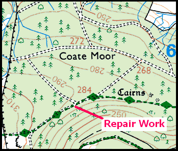
The labours of those who attended the event were directed at repairing some of the CW long distance path on Coate Moor - just to the east of Captain Cook's monument (see the picture below).
The work of the SRC team was supervised by two NYM rangers (Andrew and Steven). The section of the CW that was being repaired was that near {NZ 595 102} - see the followingmap section:
[Crown Copyright 2009. All rights reserved. Licence number: 100046831].
All those who participated in the path repairing activity were rewarded for their efforts by being given a badge that was produced to commemorate the 40 years history of the CW - see the picture below.
On behalf of all those walkers who use the section of the Cleveland Way between Gribdale Gate and Kildale, many thanks for your (the volunteers) sterling efforts in relation to keeping the terrain under-foot in a reasonable condition.
Click the buttons below to find out more about the day's activities and/or read a personal reflection on walking the Cleveland Way.
Click this link to see the SRC Pinboard Comments for this event.
During the week beginning 1st June, Stockton Rambling Club will have TWO mid-week events available. One is an evening walk and the other is a visit (with an optional walk).
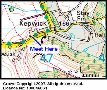
The evening walk is on Wednesday, 3rd June and will start at 7.00 pm from Kepwick Church car park {SE 467 908} - see the map below.
This walk will be not be longer than 6 miles. Please ring 01642-715773 for more details.
The visit is on Thursday, 4th June and will take in Birkheads Secret Gardens - near Causey Arch {NZ 220 569} - see the map below.
Crown Copyright 2009. All rights reserved. Licence No. 100046831. Produced using Anquet Maps.
This event will start at 11.00 am and will cost £3.50.
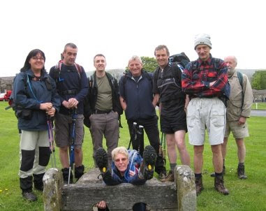
Our previous 'Castleton Capers' (on 12th April) took us from Castleton to Great Ayton - click here to see the details of our previous expedition. In contrast, today's capers (24th May) took us into Castleton as our finishing point. We started near Brown Hill {NZ 670 118} and then passed through Westworth Wood, Guisborough Woods, Percy Cross, Kildale and Westerdale to reach our final destination at Castleton {GR 681 077}.
We set off at about 11.40 am from the isolated footpath sign {NZ 670 118} on the minor road that leads from the A171 to Castleton. There were eight of us in the group: PB, RB, KF, JG, JJ, MuS, JY and PY. JJ led the walk.
From our starting location we set off in a north-westerly direction and headed for the Quakers' Causeway. We had some good views of Lockwood Beck and the north-east coastline as we headed towards Hob Cross {NZ 646 133} and Westworth Wood {NZ 636 139}. Our route then took us into Guisborough Woods at {NZ 635 143}.
After entering Guisborough Woods we took a broad, westerly track from {NZ 634 144} and then joined the Cleveland Way (CW) at {NZ 618 140}. We followed the CW (in a westerly direction) to Highcliff Nab {NZ 610 138} and onwards until we reached a point just south of Highcliffe Farm {NZ 609 132}. Here we left the CW in order to make an exciting crossing over marshland using an ill-defined path that eventually took us to Percy Cross Rigg {NZ 606 119}. Click here to see further details of our crossing.
We now headed south, dropping down to Lonsdale Farm {NZ 605 108}, and then had a good climb up onto the eastern end of Coate Moor where we rejoined the CW {NZ 605 105}. Dropping down through Bankside Farm, we took our lunch break at a pleasant spot {NZ 603 098} overlooking Kildale Station.
We left the CW (again!) in Kildale where we turned left along the minor road passing Kildale Hall. At {NZ 612 095} we turned right into Green Gate Lane; this took us to Little Kildale and a good climb up to Warren Farm. From here we descended to Leven Vale {NZ 626 088} and then climbed up onto Kildale Moor. Now descending into Baysdale {NZ 632 078}, we picked up a good track running in an easterly direction parallel to Baysdale Beck. At {NZ 644 076} we turned right - leaving the track in order to get down to Baysdale Beck itself {NZ 644 074}. We had a pleasant and enjoyable tea break at {NZ 646 074} - MuS provided us with slices of 'Malteser Loaf' while JJ and PY cooled off their feet in the beck.
After our short break, we continued on our easterly trek along the bank of the river in order to get to Hob Hole. Using the road to cross the beck, we now had another good climb up onto Westerdale Moor in order to find a footpath on our left at {NZ 657 070}. We followed this in an easterly direction (passing Dale View on our right) to reach Carr House {GR 675 073}. From here we climbed in a north-easterly direction up onto Rigg End {GR 681 077} - where we met our coach. However, this was not the end of our trek! We descended down into Castleton in order to take some refreshments in the Downe Arms - see the picture below.
The final climb of the day took us from the pub back up to our waiting coach.
Many thanks to JJ for organising such an interesting and exciting adventure for us today. We had a really great time. Use the buttons below to see where we went, how we did and some of the sights we saw.
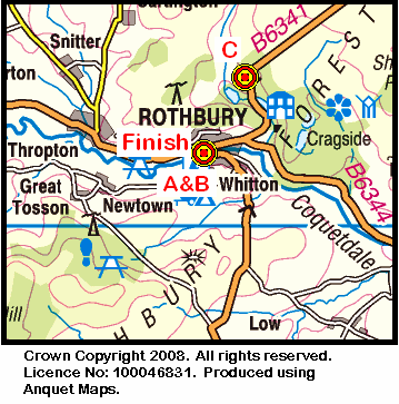
On Sunday, 31st May, the Stockton Rambling Club will have three walks in the Coquetdale area of Northumberland. All walks will finish in Rothbury {NU 056 015} - see the following map.
The A-walk will start in Rothbury and will follow a circular route that will take in The Beacon, Simonside, Bickerton and Summerville.
The B-walk will also commence in Rothbury. Following a circular route, it will visit The Beacon, Simonside, Great Tosson and Ship Crag.
The C-walk will set off from near Debdon Drift {NU 067 033} on the B6341 road (to Alnick) and will pass through Crocky's Heugh, Chapel Hill, Thropton and Summerville.
This is a Route 3 coach pick up and is also an early start (Acklam: 9.00 am, Stockton: 9.15 am and Billingham: 9.30 am).
Wensleydale is a wonderful area both for walking and for following other outdoor pursuits such as fishing, photography and bird watching. Today's expedition (17-05-2009) took us to this picturesque part of North Yorkshire. Starting at Bainbridge {SD 934 902}, we trekked to Marsett, Bardale Head and along the Pennine Way (PW) back to Hawes {SD 875 898}.
We set off from the 'stocks' on Bainbridge village green at about 11.20 am. There were 9 of us in the group: JB, PB, RB, KF, JJ, JP, WM, JY and PY. JJ led the walk.
We left the village in a south-easterly direction along the A684 road (passing the waterfalls on our right) and then turned onto a southerly bearing in order to follow the route of the River Bain (upstream) to Semer Water - our first climb being over Bracken Hill. From Semer Water Bridge {SD 921 877}, we followed a minor road in a south-easterly direction to pick up the public footpath at Low Blean {SD 924 872}. This took us along the southern shore of the lake towards Stalling Busk which we skirted pass (on the north side) in order to get to the village of Marsett {SD 903 862}.
From Marsett Bridge we followed a footpath that took us in a westerly (becoming south-westerly) direction to reach Bardale Head and the minor road that lies just beyond it at {SD 862 846}. The climb up onto Bardale Head started just after West Scrag {SD 893 862} and ended at the minor road. Our road walking took us to North Gate (1923 ft) - with good views of Dodd Fell on our right.
Just after North Gate we made a minor deviation to our route - in order to minimise the amount of road walking we had to do. We left the road at SD 850 838 and followed a boundary wall in a north-westerly direction towards Swallow Hole. Staying with this wall (on our right) we made our way to the junction of the wall with the road and the PW at Kidhow Gate {SD 830 834}.
Click this link to see a more detailed description of our minor route amendment.
After our deviation over quite rough terrain, we now turned onto a northerly bearing and followed the PW along a good track (West Cam Road)that gave us some tremendous views of the terrain that lay to the west of our route - Widdale and Widdale Fell.
We started our descent from the high ground (we were now at 1867 ft) near the tarns at Ten End {SD 844 871}. Staying with the PW, we dropped down over Rottenstone Hill to reach Gaudy Lane. We followed this towards Gayle. From here we chased the route of Gayle Beck into Hawes - where the day's expedition ended in a traditional fashion - a pot of tea or a glass of ale!
Many thanks to JJ for organising such an interesting and exciting adventure for us today. We had a really great time; we especially liked the road-avoidance deviation strategy near Dodd Fell Hill!
Use the buttons below to see where we went, how we did and some of the sights we saw.
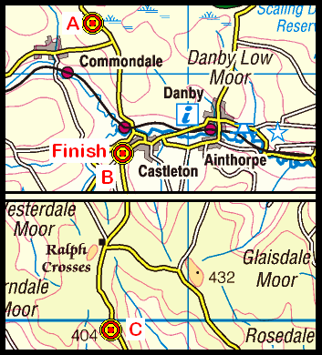
On Sunday, 24th May, the Stockton Rambling Club will have three walks in the North-Central area of the North York Moors. All walks will finish in Castleton {NZ 682 078} - see the following map.
The A-walk will start at Brown Hill {NZ 674 113} and will take in Hob on the Hill, Percy Cross Rigg and Westerdale.
The B-walk will commence at Castleton and will follow a circular route which will visit Wolf Pit, Fryup Gill, Danby Castle and Ainthorpe.
The C-walk will set off from the Lion Inn {SE 678 997} on Blakey Ridge and will pass through High Blakey Moor, Esklets and Dale View.
This is a Route 1 coach pick up (Billingham: 9.30 am, Stockton: 9.45 am and Acklam: 10.00 am).
During the week beginning 18th May, Stockton Rambling Club will have THREE mid-week events available. The first is a day walk, the second is an evening walk and the third is a North York Moors (NYM) Volunteers Day.
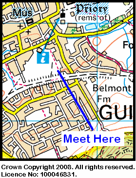
The day walk and will take place on Wednesday, 20th May. It will start at 10.30 am from Nunthorpe Church {NZ 540 140} - see the map below.
This walk will not be longer than 5 miles. Please ring 01642-715773 for more details.
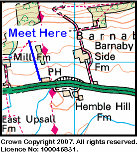
The evening walk will also take place on Wednesday, 20th May. It will start at 7.00 pm from the Cross Keys Inn on the A171 road {NZ 567 158} - see the map below.
The length of this walk will be up to 6 miles. Please telephone 01642-570861 for more details.
The NYM Volunteers Day will take place on Thursday, 21st May. Please telephone 01740-644347 for more details and/or click the purple information button below.
Today's expedition (10-05-2009) was a substitute for the Ilam weekend adventures which, unfortunately, had to be cancelled.
We set off from the round-about on the A171 Whitby road {NZ 870 099} (see the picture below) at about 10.50 am. There were 7 people in the group: JB, LB, PB, RB, CH, MH and WM. WM led the walk.
After leaving the round-about, we headed off in a northerly direction to pass through the small village of Newholm and then went across several fields in order to reach Raithwaite Hall. From here we dropped down to the coast at Sandsend and went across the beach to the car park at {NZ 860 129}. Here we joined the Cleveland Way (CW) and followed this in a northerly direction to Kettleness. We sat on the cliffs at NZ 832 157 (MH precariously so!) to eat our lunch and admire the views of the sea and the rocks beneath us.
After lunch we continued along the CW to a public right of way (PRW) at NZ 829 155 which took us in a southerly direction to join the course of an old dismantled railway. We followed this in a westerly direction until it looped around to meet the PRW at NZ 815 142 which we then followed to Westfields Farm {NZ 813 139}. Our south-westerly trek then took us along High Dale where we encountered some beautiful, colourful displays of bluebells and gorse bushes. We continued on our SW bearing to the small village of Mickelby {NZ 803 129}. Now heading south, we passed through Ugthorpe {NZ 800 111} and Coquet Nook {NZ 799 089} to reach the A171 road - from which we originally started (some 4.5 miles to the east).
After crossing the A171 road, we steered an intricate route via Moor Side Farm, Howe House, Westonby Farm and Thornhill Farm to arrive at the venue for our tea stop. We had our short break in a very pleasant wooded area near Stonegate Beck {NZ 784 071}. After our tea stop we pushed on in a westerly direction to reach Hall Park Farm and then Underpark Farm {NZ 771 070}. Here we turned right onto a north-westerly bearing and followed a good track to Lealholm - where our coach was waiting to pick us up (see the picture below).
Many thanks to WM for organising such an interesting and exciting adventure for us today. We had a really great time. Use the buttons below to see where we went, how we did and some of the sights we saw.
On Sunday, 17th May, the Stockton Rambling Club will have three walks in the Wesleydale area of North Yorkshire. All walks will finish in Hawes {SD 874 898} - see the following map.
The A-walk will start at Bainbridge {SD 934 901} and will take in Marsett, Bardale Head and part of the Pennine Way.
The B-walk will commence at Hawes {SD 874 898} and will take a circular route that visits Gayle, Cam High Road and a section of the Pennine Way.
The C-walk will set off from Bainbridge {SD 934 901} and will pass through Worton, Whitfield Gill and Sedbusk.
This is a Route 2 coach pick up (Billingham: 9.30 am, Acklam: 9.45 am and Stockton: 10.00 am).
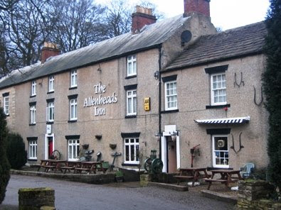
The expedition today (2009-05-03) brought us back to the Weardale area. We were last here on 29th March - click here to see details of our previous 'Weardale Wander'. Today, we went further west. Our coach dropped us off at Daddry Shield {NY 895 380} and picked us up again in Allenheads {NY 859 453}. In between these locations, we visited Cowshill {NY 855 405}, Killhope Lead Mining Centre {NY 824 432}, Peasmeadows {NY 852 470} and Byerhope {NY 867 462}.
There were nine people in the group: JB, PB, RB, KF, CH, MuS, JY, PY and Michael. PB led the walk. We set off from Daddry Shield at about 11.00 am. After leaving the coach we headed back to the bridge over the River Wear. After crossing the bridge, we turned left along a narrow minor road (see picture below).
After a short westerly 'warm up' along the road beside the river, we turned north into the first major climb of the day. This took us up onto Carr Brown Moor (1500 ft) and Race Head (1925 ft). From the high ground we dropped down into Cowshill. Turning onto a north-westerly bearing, we headed for Wellhope and Weardale Forest. Here we had another good climb - up Cowhorse Hill - but not to the top! We circled around at about 1800 ft in order to reach NY 816 430 and then headed east so as to cross Killhope Burn using the bridge at the Lead Mining Centre.
After crossing the A689 at NY 824 433, we encountered our next climb. This took us up over Killhope Moor (2060 ft) and onto Allendale Common; sadly, we had to miss out Killhope Law! Our north-easterly trek across the common took us pass Dodd Reservoir (on our left) to the footbridge over the River East Allen at {NY 851 471} near Peasmeadows. We crossed the B6295 road and then faced another good climb - from the road up onto Byerhope Bank (1650 ft) {NY 861 472}.
Staying on the high ground, we now followed a south-easterly bearing in order to reach the Rookhope road at {NY 869 453}. From here, we followed a footpath in a westerly direction that took us downhill to meet the road we had just crossed! We joined the road and followed it into the centre of Allenheads (see picture below) where we met up with our coach and the other walkers.
What a great day we had: beautiful scenery, good climbs, tremendous views, gorgeous weather and,of course, wonderful company. Yet another marvellous day in Weardale.
Click the buttons below to see the GPS tracklog, the walk statistics and the photographs that we took.
On Sunday, 10th May, the Stockton Rambling Club will have three walks in the Whitby area of the North York Moors. All walks will finish in Lealholm {NZ 764 078} - see the following map.
The A-walk will start at Whitby {NZ 899 110} and will follow the Cleveland Way to Kettleness; it will then take in Barnby Dales, Mickleby, Ugthorpe and Barton Howle.
The B-walk will also commence at Whitby and will visit Ruswarp, Aislaby, Moorgate Farm, Ugthorpe Hall and Stonegate.
The C-walk will set off from Selly Hill {NZ 860 095} and will pass through Dunsley, Mulgrave Farm, Ugthorpe, Croquet Nook, Barton Howle and Hill House Farm.
This is a Route 1 coach pick up (Billingham: 9.30 am, Stockton: 9.45 am and Acklam: 10.00 am).


 This walk will not be longer than 6 miles.
 The length of this walk will be up to 10 miles.