Thursday, 25 February 2010

A-Walking: Stanghow Stunner

Our walks this Sunday (21st February) took us into the East Cleveland area of the North York Moors. The A walk started from Brotton while the B-Walk and C-Walk both commenced at Carlin How. All of the walks terminated in Guisborough.

During its expedition, the A-Group visited Warsett Hill, Skinningrove, Carlin How, Kilton Thorpe, Stanghow and Westworth Wood before finally arriving at its destination.

We set off from our drop-off point on the A174 road at about 10.25 am. There were 11 people in the group: JB JPB, PB, RB, KF, CH, MH, JH, MS, JY and PY. CH and MH led the walk.

From the public footpath sign on the A174 road {NZ 697 193} we set off on a north-westerly trek towards the cemetery on the eastern side of Brotton {NZ 692 197}. Turning right, we now headed north to the club house at Hunley Hall Golf Course {NZ 692 204}. Maintaining our northerly bearing we passed the golf course (on our right) and continued onto Warsett Hill. We made a quick detour to visit the trig point {NZ 692 214} (see picture below) and then descended in an easterly direction. After crossing the railway track at {NZ 698 212}, we joined the Cleveland Way (CW) at {NZ 701 211}.

Warsett Hill
We followed the CW in a south-easterly direction to Skinningrove {NZ 713 199} where we picked up the Cleveland Street footpath. This took us on a good climb up to the A174 road in Carlin How {NZ 708 192} and then across a number of fields (in a westerly direction) to reach the disused ironstone mines at {NZ 686 187} - Lumpsey Ironstone Mines (see here). Because of the inclement weather conditions (snow, snow and more snow), we decided to take what shelter we could from the ruined mine buildings in order to take our lunch stop.

After lunch we followed the course of the dismantled railway in a southerly direction to the minor road (Kilton Lane) near Kilton Thorpe {NZ 690 175}. From the dismantled railway bridge, we took an easterly bearing along a path that led us to Stank House Farm {NZ 698 174}. As we approached the farm we found that there was a substantial amount of flooding (see the picture below) which caused us to make a slight diversion to the official route.

Stank House Farm
From Stank House Farm, we made our way on a south-westerly bearing to Buck Rush Farm {NZ 692 164} and onwards to the village of Stanghow {NZ 674 156} - where the snow falls had produced some really stunning views. We now followed a snow-laden, westerly going road across Stanghow Ridge. At the junction of this road with Jenny Frisk Road (from Boosbeck) {NZ 661 153}, we changed to a south-westerly bearing and trekked across Low Moor to reach the beacon at the car park at the top of Birk Brow Road (the A171) {NZ 658 149}.

Birk Brow Car Park
After a short tea stop, standing about in the snow, we crossed the A171 road and followed a snow-laden path in a south-westerly direction to the path junction at Woodhill Gill Head {NZ 656 141}. We now followed a south-going path over Stanghow Moor to the path junction at {NZ 659 123} on High Moor. At this point we executed an 'about turn' and headed off on a north-westerly bearing to Westworth Wood {NZ 636 139} - where we met two familiar faces (JJ and JG).

We trekked through the wood and re-joined the Cleveland Way at {NZ 630 145}. Following this in a westerly direction through Guisborough Woods, we located a north-going footpath at {NZ 622 144} that took us in a northerly direction (downhill) to the bottom of Belman Bank {NZ 622 148}. From here we maintained our north-westerly trek to reach the car park at the centre of Guisborough {NZ 615 158} where our coach was waiting to take us home.

As most of our route today was on relatively high ground, we were exposed to one long 'snow shower'. During the day the intensity of the snow fall varied from light to heavy. There was also considerable amounts of snow and ice under-foot. Despite the harsh winter conditions we had a great day and we were exposed to some superb snow scenes.

Many thanks to CH and MH for organising such an interesting and exciting adventure for us today. We had a really great time - and we really appreciated the snow. Use the buttons below to see where we went, how we did and some of the delightful sights that we saw.


Labels:

Wednesday, 24 February 2010

Mid-Week Walking - Castle Eden Dene

On Thursday, 4th March, Stockton Rambling Club have a mid-week walk in the Castle Eden Dene area of County Durham. Please meet at 10.30 am at the Oakerside Dene Lodge Car Park {NZ 428 393} - see the following map.

Map of the Castle Eden Dene area
Crown Copyright (2009). All rights reserved. Licence No. 100046831.
Produced using Anquet Maps.

The walk will not be longer than 10 miles.
For further details ring 01642-805781.


Labels:

Monday, 22 February 2010

Sunday Walking to Bishop Auckland

On Sunday, 28th February, the Stockton Rambling Club will have three walks in the Weardale area of County Durham. All walks will finish in Bishop Auckland {NZ 211 301} - see the following map. Click on the map in order to see a larger version.

Map of the Frosterley to Bishop Auckland area
Crown Copyright (2009). All rights reserved. Licence No. 100046831.
Produced using Anquet Maps.


The A-walk will start at Frosterley {NZ 025 369} and will take in Low Harperley, Witton-le-Wear and Escomb.

The B-walk will commence at Wolsinghham {NZ 077 372} and will visit Bradley Cottage, Low Harperley, and the Weardale Way.

The C-walk will set off from Eels Bridge {NZ 115 357} and will pass through the Weardale Way, Witton-le-Wear and Escomb.

This is a Route 3 coach pick up (Acklam: 9.30 am, Stockton: 9.45 am and Billingham: 10.00 am).


Labels:

Saturday, 20 February 2010

A-Walking: Richmond Runner

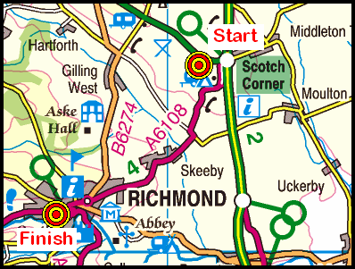
Each of our three walks today (Sunday, 14th February) set off from the Sedbury layby on the west-bound carraigeway of the A66(T) road near Scotch Corner {NZ 208 053} - see the picture below. All of the walks subsequently finished in the beautifully situated town of Richmond {NZ 168 011} with its magnificent castle.

Sedbury Layby
From the layby, the A-group made its way to Gilling West, Hartforth, Ravensworth, Kirby Hill, Sturdy House Farm, Willance's Leap, the Applegarths and Round Howe before finally arriving at its destination in Richmond.

We set off from our drop-off point at about 10.30 am.There were 6 people in the group: JB, PB, CH, JH, MS and WM. PB led the walk.

Taking an overall easterly bearing, we made our way through Sedbury Park and across the fields in order to reach Gilling West {NZ 183 052}. We crossed Gilling Beck and entered the village from the south side of the river.

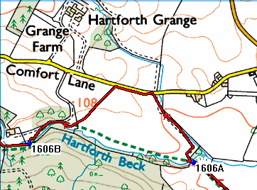
After passing the church on our left, we departed from the village at {NZ 184 053}. Taking a north-easterly bearing we trekked towards and over Bayhams Hill {NZ 176 059} and then continued onwards to Hartforth {NZ 172 062}. Turning left, we followed Jagger Lane for about 155 yards and then turned right onto a good track. We maintained our north-eastly bearing along this track in order to reach the ford and footbridge over Hartforth Beck at {NZ 167 064}.

After crossing the beck we made our first navigational error of the day. Instead of turning sharp left and following the beck, we did an unintentional anti-clockwise half-circle around a field of turnips.

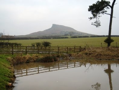
Hartforth Beck
Crown Copyright (2009). All rights reserved. Licence No. 100046831.
Produced using Memory-Map.

After we had recovered the situation, we continued on our planned north-westerly bearing to Whashton Bridge {NZ 155 068} and the minor road at {NZ 145 076}. Turning right, we followed this road into Ravensworth {NZ 141 079} where we had lunch sitting in the sun on the village green. There was ample seating provided.

Following our very pleasant lunch stop, we headed south - passing Ravensworth Castle on our left. As we approached Kirby Hill {NZ 140 066}. we had our first major climb of the day. After the climb up to the village, we had some really good views of the terrain to the north of us - from where we had come.

Leaving the village on a southerly bearing, we continued to gain height until we reached the MOD land and the stile at {NZ 138 060}. We maintained our southerly bearing until we reached the road at Sturdy House Farm {NZ 137 050}. We followed the road (Sturdy House Lane) in a south-westerly direction to {NZ 135 047}. We now turned on to a bearing of 153° and followed Green Lane over High Moor to reach Silver Hill and Coalsgarth Gate {NZ 142 031}.

Maintaining our south-easterly bearing, we followed the public footpath along Coalsgarth Edge to reach a minor road at {NZ 151 022} near Beacon Cottage. We turned right, and in 140 yards turned left onto a south-going footpath at {NZ 150 022}. This took us across High Moor and eventually led us downhill to Whitcliffe Farm {NZ 152 015}.

At the road, we turned right and made our way in a westerly direction to High Leases {NZ 149 014}. We now climbed back up onto High Moor and, following a north-westerly path, we made our way to Willance's Leap {NZ 136 021}. We took a short tea stop here.

From the monument above Whitcliffe Scar we followed a muddy and slippery path in a westerly direction around to the road at {NZ 129 024}. We now used the access track to descend to the Applegarths {NZ 129 017} and the northern bank of the River Swale at {NZ 134 014}.

River Swale
Now following the public footpath along the northern side of the river, we progressed to the southern edge of Whitecliffe Wood {NZ 145 010}. Passing through the wood on a good track, we made our way to Lownethwaite Farm {NZ 149 009} and the A6108 (Reeth Road) at {NZ 155 008}.

After crossing the road we made our way through the car park and used the footbridge at {NZ 157 008} to cross the River Swale. Passing Round Howe on our right,we maintained our easterly bearing to re-join the River Swale again at {NZ 165 006}. Now following the river-side path we followed the south side of the river to Richmond Bridge {NZ 170 006}.

Turning left, we crossed the river (once more) and then in 110 yards turned left again. This gave us a very good view of Culloden Tower in Temple Grounds {NZ 169 007} (see here). Turning right, our final ascent then involved a good climb up to the A6108 - using the road that runs along the eastern edge of Temple Grounds. After crossing the A6108, we had just a short walk to the car park in the centre of Richmond {NZ 168 011} where our coach was waiting for us.

Again, we had yet another interesting and exciting adventure today. Undoubtedly, we had a really great time - with so many interesting things to see and enjoy. Use the buttons below to see where we went, how we did and some of the sights we saw.


Thursday, 18 February 2010

Mid-Week Walking from Sutton Bank

On Thursday, 25th February, Stockton Rambling Club have a mid-week walk in the Sutton Bank area of the North York Moors. Please meet at 10.30 am at the Sutton Bank car park {SE 516 830} - see the following map.

Map of the Sutton Bank area
Crown Copyright (2009). All rights reserved. Licence No. 100046831.
Produced using Anquet Maps.

The walk will not be longer than 8 miles and will involve 1250 feet of ascent. Car parking costs £2-20.
For further details ring 01642-656273.


Labels:

Monday, 15 February 2010

Sunday Walking to Guisborough

On Sunday, 21st February, the Stockton Rambling Club will have three walks in the Western Region of the North York Moors. All walks will finish in Guisborough {NZ 614 158} - see the following map.

Map of the Brotton to Guisborough area
Crown Copyright (2009). All rights reserved. Licence No. 100046831.
Produced using Anquet Maps.

The A-walk will start at Brotton {NZ 690 198} and will take in Carlin How, Kilton Thorpe, Stanghow and Westworth Wood.

The B-walk will commence at Carlin How {NZ 705 193} and will visit Kilton Thorpe, Stanghow and Westworth Wood.

The C-walk will also set off from Carlin How and will pass through North Skelton, Skelton Green, Slapewath and West Banks.

This is a Route 1 coach pick up (Billingham: 9.30 am, Stockton: 9.45 am and Acklam: 10.00 am).


Labels:

Mid-Week Walking from Stockton

On Wednesday, 17th February, Stockton Rambling Club have a mid-week walk in the Stockton area of the Tees Valley. Please meet at 10.30 am at The Endeavour at Stockton Riverside {NZ 446 187} - see the following map.

Map of the Stockton Riverside area
Crown Copyright (2009). All rights reserved. Licence No. 100046831.
Produced using Memory-Map.

The walk will not be longer than 5 miles.
For further details ring 01642-780538.


Labels:

Thursday, 11 February 2010

Special Mid-Week Evening Event - Mountain Rescue

On Tuesday, 16th February, Stockton Rambling Club have a special mid-week event. This will take the form of an illustrated talk by a member of the Cleveland Search and Rescue Team. The event will take place at the Linthorpe Community Centre in Middlesbrough. Please meet at 7.30 pm at the community centre {NZ 491 186} - see the following map.

Map of the Linthorpe area
Crown Copyright (2009). All rights reserved. Licence No. 100046831.
Produced using Anquet Maps.

The cost of this event is £2-00.
Bring your own refreshments.
For further details please ring Bill-M on 01740-644347.


Labels:

Wednesday, 10 February 2010

A-Walking: Stokesley Sprinter

Our walks today took us into the western region of the North York Moors. The A-walk started from Primrose Hill, the B-walk set off from Easby and the C-walk departed from Battersby Avenue. All walks finished in Stokesley.

From Primrose Hill {NZ 552 087}, the A-walk went to Red Hall, Ingleby Greenhow, Battersby, Kildale and Roseberry Common, Aireyholme Farm and Great Ayton before finally arriving at Stokesley.

We set off from our drop-off point at about 10.05 am. There were six people in the group: JB, PB, RB, KF, LM and WM. JB led the walk.

Primrose Hill
We left Primrose Hill on a south-easterly bearing towards Little Broughton {NZ 560 078} and the minor road at {NZ 560 068} near Red Hall. We continued on our south-easterly bearing to reach Meynell Hall {NZ 564 062}. Turning left onto an easterly bearing, we crossed Little Broughton Beck and continued across some very muddy fields to reach the minor road (Marsh Lane) at {NZ 572 065}. We then followed the road into and around Ingleby Greenhow {NZ 582 064}.

Leaving the village on a north-easterly bearing (passing the school on our right) we navigated around a series of fields in order to reach Station Farm {NZ 584 071} and Battersby Junction {NZ 588 072}. Now following a north-easterly path along the side of the railway, we found a bridge/tunnel at {NZ 591 076} that enabled us to pass underneath the railway line. We then zig-zagged (in an easterly direction) along some field boundaries in order to reach the small village of Battersby {NZ 596 076}.

Leaving the road at (NZ 598 077}, we continued in a north-easterly direction to {NZ 603 080}. We now turned left and walked on a northerly bearing to Low Farm {NZ 601 081}, Park Farm {NZ 602 085} and the minor road at {NZ 604 090}. Turning left, and in 190 yards turning right, we followed the road into the village of Kildale {NZ 608 094} where we had a short lunch stop in the shelter. There were just enough seats inside to accommodate the six of us.

Kildale
After lunch, we left the village on a northerly bearing to pass under the railway bridge at {NZ 607 096}. Now following the route of the Cleveland Way (CW), we had a good climb up - passing Bankside Farm {NZ 605 101} as we went - to reach the high ground in Pale End Plantation {NZ 605 105}. Turning left, we now left the road and followed the CW in a westerly direction through the woods on Coate Moor in order to reach Captain Cook's Monument {NZ 590 101}. Turning right onto a northerly bearing, and staying with the CW, we dropped down to the car park at Gribdale Gate {NZ 592 110}.

From the car park we had another good climb up onto Great Ayton Moor. As we moved north along the Cleveland Way we encountered substantial volumes of snow and ice - which made the going underfoot quite difficult. At {NZ 592 124} we changed our bearing to 310° and headed for the gate at {NZ 588 127} on Newton Moor.

After a short 'catch-up' stop, we dropped down onto Roseberry Common and then left the CW at {NZ 583 127} by turning left in order to follow a track in a south-westerly direction to Aireyholme Farm {NZ 579 116}. We stopped here for our tea stop. Again the seating arrangements were just sufficient for the six of us - and the views that we had were quite spectacular.

Aireyholme Farm
We left our tea spot by following the farm access track in a downhill direction through Slacks Quarry in order to find a footpath on our right at {NZ 578 112}. We followed this in a north-westerly direction through Cliff Ridge Wood to reach a path junction at {NZ 574 114}. Turning left, we descended from the wood over Rye Hill to the railway track {NZ 571 112} and the minor road at {NZ 563 108} on the eastern side of the village of Great Ayton.

We navigated a westerly-going route through the village and crossed the River Leven using the footbridge at {NZ 555 105}. Turning left, we continued our trek along the minor road (Yarm Lane) to reach a footpath on our left at {NZ 552 104}. We followed this in a westerly direction to meet the A172 road at {NZ 531 090}. After crossing the road, we followed the footpath towards the centre of Stokesley. At the roundabout on the B1257 road, we turned left and followed the road in a south-westerly direction for about 150 yards to where our coach was waiting for us {NZ 528 086}.

Many thanks to JB for organising such an interesting and exciting adventure for us today. We had a really great time. Use the buttons below to see where we went, how we did and some of the sights we saw.


Labels:

Tuesday, 9 February 2010

Sunday Walking to Richmond

On Sunday, 14th February, the Stockton Rambling Club will have three walks in the Swaledale area of North Yorkshire. All walks will start at Scotch Corner {NZ 208 052} and will finish in Richmond {NZ 168 011} - see the following map.

Map of the Scotch Corner to Richmond area
Crown Copyright (2009). All rights reserved. Licence No. 100046831.
Produced using Anquet Maps.

The A-walk will take in Gilling West, Hartforth, Sturdy House Farm, Ravensworth, Willance's Leap and Applegarth.

The B-walk will visit Gilling West, Jockey Cap, Applegarth and Round Howe.

The C-walk will pass through The Ashes, Jockey Cap and Coalsgarth.

This is a Route 2 coach pick up (Billingham: 9.30 am, Acklam: 9.45 am and Stockton: 10.00 am).


Labels:

Monday, 8 February 2010

Mid-Week Walking in Swaledale

On Thursday, 11th February, Stockton Rambling Club have a mid-week walk in the Swaledale area of North Yorkshire. Please meet at 10.30 am at the Richmond Swimming Pool {NZ 176 009} - see the following map.

Map of the Richmond area
The walk will not be longer than 10 miles.
For further details ring 01642-805781.


Labels:

Tuesday, 2 February 2010

C-Walking: Durham Delights

Today's three walks were all located in the County Durham area. The A-walk and C-walk each started at Byers Green while the B-walk departed from the A690 road near Stockley Bridge. All walks finished in Durham City.

The C-walk set off at 10.05 am from near the centre of Byers Green {NZ 224 340}. Our route today was to take us towards Tudhoe Village, Sunderland Bridge, Croxdale Hall, Shincliffe and Durham City. There were 7 people in the group: MB, PB, SB, IG, MM, CP and SQ. PB led the walk.

From our drop-off point, we walked in a south-easterly direction along the main road to reach the war memorial {NZ 225 338} (see the picture below) where we turned left into Hagg Lane.

Byers Green
We followed Hagg Lane in a north-easterly direction to its junction with the minor road (Whitworth Road) at {NZ 235 346} near Whitworth Church. Turning right, we now followed the road in a south-easterly direction for about 380 yards to the entrance of Whitworth Hall Country Park. We entered the car park and lingered for a short while admiring the lake and the overall ambience of the location.

Leaving the car park, we followed the public footpath for about 200 yards and then had a short coffee stop. We sat on some conveniently located logs - basking in the glorious mid-morning sunshine.

After our coffee break, we set off along a north-easterly path towards Middle Burtons {NZ 244 347}. Turning left along a good track, we now made our way north - through a delightful woodland - to Lower Burtons {NZ 245 350}.

Returning to a north-easterly bearing, we progressed to a path junction at {NZ 247 353}. Turning right, we followed the path through the wood in an easterly direction in order to reach the bridge over Valley Burn at {NZ 253 355}. After crossing this, we made our way on a north-north-westerly bearing to the minor road near the sewage works at {NZ 252 356}.

We followed this road in a northerly direction to its junction with the westerly-going minor road from Tudhoe Village. Just after the junction, at {NZ 254 360}, we took a north-easterly track across the fields in order to reach Coldstream Wood {NZ 259 366}. We passed through the wood, reaching the footbridge over Nickynack Beck at {NZ 259 370}.

Now moving in a north-easterly direction, we maintained this bearing along a good track that took us to Croxdale Viaduct {NZ 264 376} and Sunderland Bridge {NZ 265 377}. We took our lunch break on the south side of the bridge, basking in the sun on the eastern bank of the River Wear.

Sunderland Bridge
After lunch we joined the Weardale Way (WW) at Croxdale Bridge and followed this in a north-easterly direction to reach Croxdale Hall {NZ 274 379}. We then made our way along the edge of Croxdale Wood and Butterby Wood in order to reach a footpath just beyond High Butterby Farm {NZ 289 388}. Now changing to a north-westerly bearing, we descended through the woods to reach the eastern bank of the River Wear {NZ 287 391}. We then followed the route of the river to Shincliffe Wood.

We continued along the WW, passing Shincliffe Hall {NZ 288 401} (on our left) in order to reach the A177 road {NZ 289 409} near the village of Shincliffe. From Shincliffe Bridge, we followed the Weardale Way along the bank of the River Wear to {NZ 285 417}. Staying on the WW, we then navigated a route to the footbridge over Old Durham Beck {NZ 286 418}. Making our way north, we re-joined the River Wear near Pelaw wood {NZ 286 422}. We stopped for a few minutes - watching the rowing teams honing their skills with their oars (see here).

From Pelaw Wood, our path now took us in a westerly direction towards the centre of Durham City. We left the river at {NZ 275 424} and climbed up a steep flight of stone steps to reach the road. Turning left, we followed the road through the centre of Durham towards the church near {NZ 276 427}. From here, we made our way towards The Sands car park {NZ 275 430} where our coach was waiting to take us home.

Durham City
Despite Saturday's fall of snow, the walking conditions today were really excellent. The cold weather meant that all the muddy paths (that might have been) were frozen solid. They were therefore and a 'pleasure' to walk on - considering what they might have been like had it not snowed yesterday.


Labels:

Monday, 1 February 2010

Sunday Walking to Stokesley

On Sunday, 7th February, the Stockton Rambling Club will have three walks in the Western Region of the North York Moors. All walks will finish in Stokesley {NZ 524 086} - see the following map.

Map of the Battersby-Stokesley area
Crown Copyright (2009). All rights reserved. Licence No. 100046831.
Produced using Anquet Maps.

The A-walk will start at Primrose Hill {NZ 552 087} and will take in Red Hall, Battersby, KIldale and Roseberry Common.

The B-walk will commence at Easby {NZ 576 086} and will visit Battersby, Kildale, Cleveland Way, Roseberry Common and Great Ayton.

The C-walk will set off from Battersby Avenue {NZ 585 083} and will pass through Battersby, Kildale, MillBank Wood and Great Ayton.

This is a Route 1 coach pick up (Billingham: 9.30 am, Stockton: 9.45 am and Acklam: 10.00 am).