Memories of Hury Reservoir
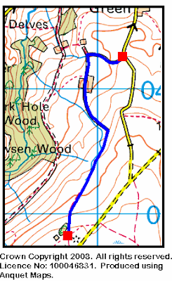
We often walk in the Baldersdale area which is where the Hury Reservoir {NY 965 196} is located - see the map below.

The reservoir lies about four miles south of Middleton-in-Teesdale and three miles to the west of Cotherstone. The dam was built in 1892 for the Stockton and Middlesbrough Water Board. It was named after the small village of Hury which lies on its northern bank (see map). The reservoir was emptied in 1991 for maintenance by Northumbrian Water Limited, Teesdale area.
The dam structure 'bridges' the River Balder as it flows east to join the River Tees at Cotherstone. Hury is one of three reservoirs that are located in Baldersdale; the other two being Blackton and Balderhead which lie further upstream - to the west of Hury. The three reservoirs (like those in Lunedale - which is further north) play host to both walkers and fisherman - all of whom enjoy the natural beauty, tranquility and solitude of this outstanding area.
Here is a picture taken from the parapet of the reservoir - looking in a south-westerly direction towards Goldsborough (on the horizon).

And here is a short video clip (taken from the south-bank) showing the extent of the dam.
Press the left-most button to start the video.
Some time ago, Brent Whittaker sent me four really good photographs that he took during the C-walk in Baldersdale on Sunday, 21st January, 2007. Essentially, the photos show different views of the Hury Reservoir taken from the north shore as they approached the dam from the east. The rightmost photograph is taken from a point furthest from the dam. Notice that in the left-most photograph Goldsborough shows up quite well on the horizon.
Click on the button below if you would like to have a look at these photos.
Further information on Baldersdale and the Hury Reservoir
Hury Reservoir can be found on Wikipedia.
Labels: Memories of Hury Reservoir
posted by philbee @ 15:36
0 Comments
![]()

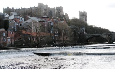 From Shincliffe we followed Hall Lane to Shincliffe Hall. As we passed through Shincliffe Woods there were some tremendous views of the River Wear as it made its way towards Durham and onwards to the coast at Sunderland.
  We carried on to and through Croxdale Hall. As we approached Sunderland Bridge we came across the B-group having their lunch. We had our lunch stop near Holywell Hall {NZ 252 370} - a picturesque spot overlooking the River Wear.
 After lunch we carried on along the western bank of the River Wear to Page Bank Bridge, Jubliee Bridge and Furness Mill Farm. Here we had another good climb (including a ladder) from the river up to the old railway line near Bell Bank. We then had some terrific panoramic views as we walked on our easterly trek towards Farnley Hill. At Farnely we turned south and headed towards the Roman Road near Binchester.
 As can be seen from the clock at the entrance to Auckland Castle, we arrived in Bishop Auckland well in advance of our required 16.45 pm deadline. Indeed we were more than 30 minutes early!
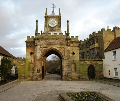 Having some time to spare, some of us decided to do a quick 'optional' tour of the grounds of the castle.
 There was an impressive array of flowers nestled on the grass banks underneath the trees. There was a profusion of yellow Winter Aconite with isolated patches of Snowdrops interspersed amongst them.
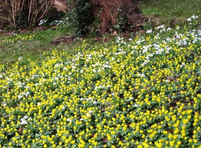 The above scene reminded me of the opening lines of William Wordsworth's famous poem:
  Judging by the profusion of flora depicted in the above two photographs, I guess Spring is well and truly on its way?